Moisture in the atmosphere drives nearly every significant weather phenomenon a pilot will encounter, from ground fog that closes airports at dawn to towering convective cells that demand a wide detour. To make sense of moisture-related hazards, pilots must understand three tightly linked concepts: relative humidity, dew point, and the temperature–dew point spread. These are not merely academic definitions — they appear on every METAR, feed directly into preflight weather analysis, and underpin the judgment calls that keep flights safe.
The authoritative source for these concepts is the FAA Aviation Weather Handbook (FAA-H-8083-28B), Chapter 6, which covers water vapor and the hydrologic cycle in detail. The explanations below expand on that source, translate the physics into practical pilot language, and highlight the testable specifics examiners love to probe.
Saturation: The Starting Point
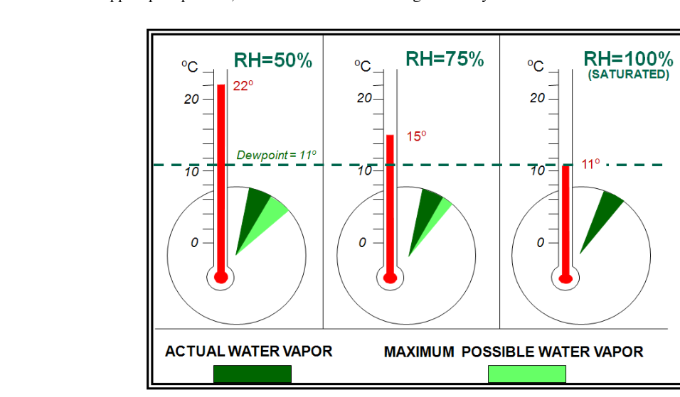
Before relative humidity makes sense, you need to understand saturation. At any given temperature and pressure, a parcel of air can hold only a finite maximum amount of water vapor. When an air parcel contains that maximum amount, it is saturated. When it holds less than the maximum, it is unsaturated. The key insight — one that catches many students off guard — is that the capacity of air to hold water vapor is directly related to temperature. Warm air can hold far more water vapor than cold air. Cool the same parcel of air without adding or removing any moisture, and it moves closer to saturation automatically, because its storage capacity has shrunk while its actual water vapor content stayed the same.
Relative Humidity: How Full Is the Tank?
Relative humidity (RH) is defined as the ratio of the water vapor actually present in an air parcel to the maximum amount that parcel could hold at the same temperature and pressure, expressed as a percentage:
Relative Humidity = (Water vapor content ÷ Water vapor capacity) × 100%
A parcel at 100% RH is saturated. A parcel at 50% RH could theoretically hold twice as much moisture as it currently contains. At 0% RH the air would be completely dry — a condition essentially never found in the real atmosphere.
The FAA handbook flags relative humidity as the most common yet most misunderstood measure of atmospheric moisture, and for good reason. RH does not tell you how much water vapor is actually in the air; it only tells you how close the air is to saturation. Consider a practical example drawn directly from FAA-H-8083-28B: a sea-level air parcel at 30 °C can hold up to 27 g of water vapor per kilogram of dry air. If it actually holds 8 g, RH is about 30%. Cool that same parcel — without adding or removing moisture — to 20 °C, and its capacity drops to roughly 15 g; RH climbs to about 53%. Cool it further to 10 °C, and capacity drops to 8 g — exactly what the parcel holds — so RH reaches 100% and the parcel is now saturated. The water vapor content never changed; only the temperature (and therefore the capacity) changed.
This temperature-dependence explains why a hot, muggy afternoon can have a lower RH than a cool, crisp morning, even though the afternoon air holds far more actual moisture. It also explains why heated cabin air feels dry: warming outside air increases its capacity enormously while the absolute moisture content stays low, so RH plummets.
Dew Point: The Actual Moisture Thermometer
Because relative humidity can be misleading, meteorologists and pilots rely on the dew point temperature as a direct indicator of actual moisture content. The FAA handbook defines dew point as the temperature to which an air parcel must be cooled — at constant pressure and constant water vapor pressure — for the water vapor in that parcel to begin condensing into liquid water (dew). In other words, the dew point is the temperature at which that parcel would become saturated.
A high dew point (say, 20 °C / 68 °F or above) indicates a large amount of water vapor in the air — the kind of oppressive humidity common in tropical or Gulf Coast environments in summer. A low dew point (say, −10 °C / 14 °F) indicates very dry air. Unlike relative humidity, the dew point does not change when you simply heat or cool an air parcel; it changes only when moisture is actually added to or removed from the parcel. This makes dew point a far more reliable, non-misleading indicator of the actual moisture load the atmosphere is carrying.
When the dew point falls below 0 °C (32 °F), the condensation product is frost rather than dew; for this reason the FAA handbook notes that the term frost point is sometimes used below freezing.
The Temperature–Dew Point Spread (Dew Point Depression)
The temperature–dew point spread — also called the dew point depression — is simply the difference between the current air temperature (T) and the dew point temperature (Td):
Spread = T − Td
This single number is one of the most operationally useful values on a METAR. As the spread decreases, relative humidity increases. When the spread reaches zero, RH is 100% and the air is saturated — condensation, fog, or cloud formation is occurring or imminent. Surface METARs always report both temperature and dew point, giving pilots an instant snapshot of how close surface air is to saturation.
Why the Spread Matters: Fog, Clouds, and Cloud Bases
The FAA handbook makes an important operational distinction: surface temperature–dew point spread is a strong indicator of fog potential but has little bearing on whether precipitation will fall. Precipitation requires saturated layers extending through a thick depth of the atmosphere aloft, not merely a shallow surface layer of saturated air. Fog, by contrast, forms right at the surface when the spread collapses to near zero, which is exactly what happens on calm, clear nights as radiative cooling lowers the surface air temperature toward the dew point.
There is also a practical rule of thumb for estimating the approximate height of the base of convective (cumuliform) clouds. Because air cools at roughly the dry adiabatic lapse rate as it rises, and because the dew point decreases at a much slower rate, the two converge at a predictable altitude. The commonly used approximation — sometimes called the lifted condensation level rule — holds that cloud bases form at approximately 400 feet per 1 °C (or roughly 1,000 feet per 4 °F) of surface temperature–dew point spread. For example, a surface temperature of 30 °C and a dew point of 18 °C yields a spread of 12 °C, predicting a cloud base of approximately 12 × 400 = 4,800 feet AGL. While this is an approximation, it is widely used in field forecasting and is grounded in the physics of adiabatic cooling.
Phase Change and Latent Heat: The Energy Behind It All
When water vapor condenses at the dew point, it does not just become liquid water — it releases energy into the surrounding air. This energy, called latent heat of condensation, equals approximately 2,501 joules per gram of water condensed. That released heat warms the surrounding air, reducing the tendency of the parcel to cool further and enabling thunderstorms and other convective systems to sustain and intensify themselves. The reverse process — evaporation — absorbs the same amount of energy from the environment, which is why evaporating moisture cools surfaces and why wet-bulb temperature is always lower than dry-bulb temperature in unsaturated air. Understanding latent heat helps pilots grasp why thunderstorms are so energetic and why convective weather is so difficult to suppress once it gets started.
Key Numbers and Rules
- RH = 100%: air is saturated; condensation (fog, cloud, dew, frost) can occur.
- Spread = 0: temperature equals dew point; RH is 100%.
- Cloud base estimate: approximately 400 ft per °C (or ~1,000 ft per 4 °F) of surface T–Td spread.
- Dew point below 0 °C: product of condensation is frost (frost point).
- Latent heat of vaporization/condensation: ~2,501 J/g (absorbed during evaporation; released during condensation).
- Latent heat of fusion: ~334 J/g (absorbed during melting; released during freezing).
- Latent heat of sublimation: ~2,834 J/g (absorbed going solid→vapor; released going vapor→solid via deposition).
- A small spread (2 °C / 4 °F or less) at the surface, combined with light winds and clear skies, strongly suggests radiation fog is possible overnight.
Common Test Traps
- Confusing RH with actual moisture content. High RH does not mean there is a lot of moisture in the air — it means the air is close to its capacity. Cold air at 90% RH may hold far less actual water vapor than warm air at 40% RH.
- Thinking dew point changes when temperature changes. The dew point temperature stays essentially constant when an air parcel is simply heated or cooled (as long as no moisture is added or removed). It is RH that changes, not the dew point.
- Assuming a small spread always means fog is imminent. Fog typically requires calm winds and a mechanism for radiative cooling in addition to a small spread. Winds that mix the boundary layer can prevent fog even with a small spread.
- Confusing the spread's role in fog versus precipitation. A small surface spread forecasts potential fog or low stratus; it does NOT indicate that precipitation is likely. Precipitation requires deep saturated layers aloft.
- Getting the cloud-base formula direction wrong. A larger spread means a higher cloud base. Students sometimes reverse this and predict lower clouds when the spread is wide.