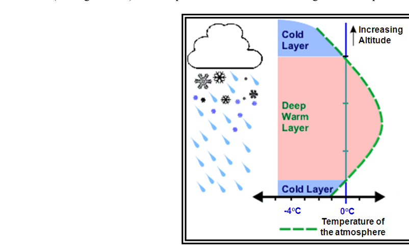
Of all the precipitation types a pilot can encounter, freezing rain is arguably the most insidious. Unlike visible ice or snow that accumulates slowly, freezing rain coats an aircraft's surfaces almost instantaneously, and it does so while the outside air temperature may read only a degree or two below zero. Understanding exactly why freezing rain forms — and what the temperature profile above you looks like when it does — is essential both for the FAA Knowledge Test and for real-world go/no-go decisions.
The FAA Aviation Weather Handbook (FAA-H-8083-28B), Chapter 14, makes clear that the type of precipitation reaching the surface is largely determined by the vertical distribution of temperature through the entire depth of the atmosphere, not just the temperature at the surface. Freezing rain is the result of one specific and dangerous arrangement of those temperatures.
How Precipitation Forms in the First Place
Before examining freezing rain specifically, it helps to understand the broader context. According to the handbook, three ingredients are required for precipitation: water vapor, sufficient lift to condense that vapor into clouds, and a growth process that allows cloud droplets to become heavy enough to fall. Significant precipitation typically demands cloud depths of at least 4,000 feet — and the heavier the precipitation, the thicker the clouds are likely to be.
Two growth processes produce precipitation. The collision-coalescence (warm rain) process occurs in warm air masses where droplets of varying sizes collide, stick together, and grow large enough to fall as rain. The ice crystal process dominates in colder, mid- and high-latitude clouds where both ice crystals and supercooled liquid water droplets coexist. Water vapor deposits preferentially onto ice crystals, which grow at the expense of liquid droplets, eventually becoming heavy enough to fall. In mid-latitudes, precipitation almost always begins as snow high in the cloud. What happens to those snowflakes on the way down depends entirely on the temperatures they encounter.
The Temperature Profile That Creates Freezing Rain
Visualize the atmosphere as a vertical stack of air layers, each with its own temperature. The normal lapse rate has temperature decreasing as altitude increases. Freezing rain requires a departure from that norm — specifically, a temperature inversion.
Here is the profile, layer by layer from top to bottom:
- Upper cloud layer (above freezing): Snow forms via the ice crystal process and begins to fall.
- Deep warm layer aloft (above 0 °C): This is the critical inversion layer — a warmer air mass has overrun a colder one below. As snowflakes descend into this deep above-freezing zone, they melt completely into liquid raindrops.
- Shallow subfreezing layer at the surface (below 0 °C): The rain falls back into below-freezing air near the ground. Because this cold layer is shallow, the drops do not have sufficient time to refreeze into ice pellets before they reach the surface.
- Surface and objects on it (below 0 °C): The still-liquid, supercooled raindrops freeze on contact with the ground, pavement, trees, power lines — and aircraft.
This is the defining characteristic of freezing rain: the below-freezing layer at the surface is too shallow to refreeze the drops in flight, so they arrive as liquid and freeze only upon impact. The handbook specifically notes that this situation commonly develops along a warm front, where a warm air mass overrides and undercuts a cold air mass trapped near the surface. The precipitation may begin as rain or snow higher up, but becomes entirely rain within the warm layer before descending into the surface cold pool.
How Freezing Rain Differs from Ice Pellets
Students frequently confuse freezing rain and ice pellets (sleet) because both involve a subfreezing surface layer. The critical difference is the depth of the warm and cold layers:
- Ice pellets: A shallow warm layer aloft partially melts the snowflakes. The precipitation then falls back into a deep below-freezing layer near the surface, giving the drops enough time to refreeze into small ice pellets before reaching the ground.
- Freezing rain: A deep warm layer aloft completely melts the snow into rain. The below-freezing surface layer is shallow, so the drops remain liquid all the way to the ground and freeze only on contact.
A practical rule of thumb: ice pellets are a warning sign that freezing rain may be occurring at a slightly higher altitude, because the same inversion structure that produces ice pellets at one location can produce freezing rain just upwind, where the warm layer is deeper and the cold layer thinner.
Why Freezing Rain Matters to Aviators
Freezing rain is one of the most hazardous weather phenomena in aviation. When supercooled raindrops contact an airframe, they spread and freeze, forming clear (glaze) ice — the densest, heaviest, and most aerodynamically disruptive form of structural icing. Clear ice is nearly transparent, making it difficult to detect visually, and it conforms tightly to wing leading edges, disrupting laminar airflow and dramatically altering the wing's lift and stall characteristics.
Because the drops are fully liquid when they hit the aircraft, they flow back along the wing before freezing, creating a smooth but irregular ice shape that standard de-ice boots may not break off effectively. The ice accumulation rate in freezing rain can exceed what any certified ice protection system is designed to handle, and it can occur even on the ground during pre-takeoff operations.
Freezing rain also poses a runway contamination hazard. A thin, nearly invisible glaze on a runway surface dramatically reduces braking effectiveness and directional control during landing rollout and rejected takeoff.
Key Numbers and Rules
- Significant precipitation requires cloud depth of at least 4,000 feet; heavier precipitation correlates with greater depth.
- Freezing rain requires a temperature inversion — specifically a deep above-freezing layer aloft over a shallow below-freezing layer at the surface.
- Ice pellets at the surface indicate the warm layer aloft is shallow; freezing rain indicates the warm layer is deep and the cold surface layer is shallow.
- Clear ice from freezing rain is the most hazardous form of structural icing — dense, hard to see, and difficult to shed.
- Freezing rain is most commonly associated with warm frontal systems where warm air overruns cold surface air.
- Hailstones of 0.75 inches in diameter or larger can cause significant aircraft damage (for context, hail originates from thunderstorms with strong updrafts, not from the inversion-driven mechanism that produces freezing rain).
Reading the Clues in a Weather Briefing
Before flight, several weather products can reveal the inversion profile associated with freezing rain. A Skew-T log-P diagram (upper-air sounding) will show the temperature and dew point at every level — a warm layer sandwiched above a cold surface layer is immediately visible. PIREPs (pilot reports) are equally valuable: a report of ice pellets from one aircraft and freezing rain from another at different altitudes over the same area paints a vivid picture of the temperature sandwich in place. METARs use the designator FZRA for freezing rain and PL for ice pellets, and SIGMETs or AIRMETs (specifically AIRMET Sierra for IFR conditions and AIRMET Zulu for icing) will be issued when these conditions are forecast.
Common Test Traps
- Confusing the depth of the layers. Exam questions frequently swap the descriptions. Remember: freezing rain = deep warm layer, shallow cold surface layer. Ice pellets = shallow warm layer, deep cold surface layer.
- Assuming surface temperature tells the whole story. Freezing rain can occur when the surface temperature is slightly above 0 °C if the aircraft or ground objects are still at subfreezing temperatures — the relevant temperature is the object's surface temperature, not the free-air temperature.
- Forgetting that precipitation type can change rapidly. As a warm front moves through, the inversion depth changes; freezing rain can transition to rain (warm layer deepens to the surface) or to ice pellets (cold layer deepens) within minutes.
- Thinking clear skies below means no icing aloft. Freezing rain can fall from an elevated cloud deck through a clear or nearly clear cold surface layer; the icing hazard exists throughout that descent, not just in cloud.
- Overlooking the 4,000-foot cloud depth rule. A METAR reporting light or greater precipitation intensity signals cloud depth exceeding 4,000 feet — directly relevant to IFR approach planning and ceiling/visibility assumptions.