Every cloud contains water, yet most clouds never produce a single raindrop that reaches the ground. The reason lies in the almost impossibly small size of individual cloud droplets. A typical cloud droplet is so tiny and light that air resistance essentially holds it in suspension, and even if it did begin to fall, it would evaporate long before completing its journey to the surface. Understanding why some clouds produce precipitation while others do not requires a close look at the two growth processes that bridge the gap between a microscopic cloud droplet and a full-sized raindrop, snowflake, or hailstone.
According to the FAA Aviation Weather Handbook (FAA-H-8083-28B), Chapter 14, precipitation formation depends on three ingredients working together: water vapor, sufficient lift to condense that vapor into cloud droplets, and a growth process that allows those droplets to become large and heavy enough to fall. The handbook discusses cloud thickness as an important factor in precipitation intensity, and as a general rule of thumb, the heavier the precipitation, the thicker the cloud is likely to be—clouds around 4,000 feet thick are often cited as producing light precipitation, with greater thickness needed for heavier rates. This is a useful benchmark worth remembering, though it is a general guideline rather than a strict cutoff.
Why Cloud Droplets Cannot Fall on Their Own
The numbers here are striking. A typical cloud droplet falling from a cloud base at 3,300 feet (1,000 meters) would, by common meteorological approximation, take on the order of many hours to reach the ground at its natural fall rate—far too slow to matter in practice. It would never make it—it would evaporate within minutes of falling below the cloud base into the drier sub-cloud air. This illustrates why cloud droplets must grow dramatically larger before precipitation can occur. Cloud physics texts commonly cite that a raindrop is on the order of a million times the volume of a single cloud droplet, an approximate figure used to illustrate the scale of growth required rather than a precise FAA-stated value. Two distinct physical processes accomplish this growth.
The Collision-Coalescence Process (Warm Rain Process)
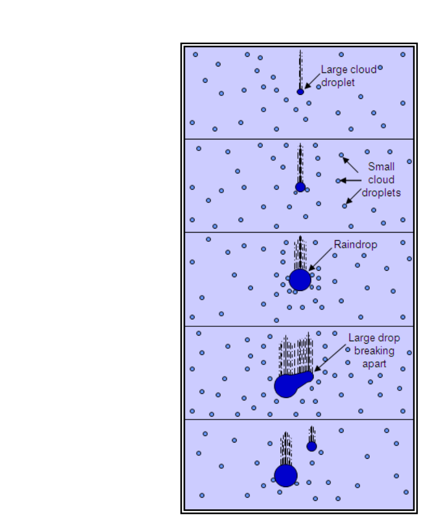
The first growth mechanism is called collision-coalescence, often referred to as the warm rain process. It operates entirely within clouds that remain above the freezing level—clouds composed entirely of liquid water droplets.
The key insight is that not all cloud droplets are the same size. Larger droplets fall slightly faster than smaller ones because gravity exerts more force on them relative to the air resistance they experience. As these larger, faster-falling droplets descend through a cloud, they sweep up smaller, slower-moving droplets in their path. Each collision causes the droplets to merge, or coalesce, forming a progressively larger drop. That larger drop then falls faster still, sweeping up even more droplets in a self-reinforcing cycle. Eventually the accumulated drop becomes too heavy to remain suspended in the updrafts that support the cloud, and it falls to the ground as rain.
Collision-coalescence is considered the primary growth process in warm tropical air masses, where the freezing level is very high—sometimes above 15,000 feet. In these environments, clouds can be deep enough and warm enough to produce heavy rainfall without ever involving ice at all. Tropical convection and warm-season showers over the Gulf Coast and Caribbean are classic examples. The efficiency of this process depends on having a wide spectrum of droplet sizes; if all droplets were the same size, they would fall at the same speed, collide less often, and coalescence would be far less effective.
The Ice-Crystal Process (Bergeron Process)
The second mechanism is called the ice-crystal process (also known as the Bergeron or Wegener-Bergeron-Findeisen process). It operates in mixed-phase clouds—clouds cold enough to contain both supercooled liquid water droplets and ice crystals simultaneously, which commonly occurs at temperatures between roughly 0 °C and −40 °C.
The physics here depend on a fundamental difference in vapor pressure. At any given sub-freezing temperature, the saturation vapor pressure over liquid water is higher than over ice. This means that in a cloud containing both supercooled water droplets and ice crystals, the air can be simultaneously supersaturated with respect to ice yet undersaturated with respect to liquid water. Water vapor therefore deposits directly onto the ice crystals (a process called deposition), while at the same time the supercooled liquid droplets evaporate to replenish that vapor. In effect, the ice crystals grow at the expense of the surrounding water droplets.
Once ice crystals grow large enough, they begin to fall, and as they fall they may collide and aggregate with other crystals, forming snowflakes. What precipitation type reaches the surface depends entirely on the temperature profile below the cloud:
- Snow falls when the temperature remains below freezing throughout the entire atmospheric column from cloud to surface.
- Ice pellets (sleet) form when snowflakes fall through a shallow above-freezing layer aloft (partially melting), then re-enter a deep below-freezing layer near the surface and refreeze into small ice pellets before reaching the ground.
- Freezing rain requires a deep above-freezing layer aloft (which completely melts the snowflake into a liquid raindrop) with only a shallow below-freezing layer at the surface. The raindrop does not have enough time in the cold air to refreeze before impact—it freezes on contact with the ground or aircraft surfaces. This situation often occurs along warm fronts where a warm air mass overrides a cold air mass, creating a temperature inversion.
- Rain results when a deep above-freezing layer extends from cloud base all the way to the surface, so any ice that forms melts completely well before reaching the ground.
The ice-crystal process is regarded as the primary precipitation mechanism in mid-latitude and high-latitude weather systems—the frontal cyclones, winter storms, and widespread stratiform precipitation events that dominate temperate climates.
Hail: A Special Case of Ice-Crystal Growth
Hail represents an extreme version of precipitation growth unique to thunderstorms. It forms when supercooled water droplets above the freezing level begin to freeze onto an existing ice particle. Additional supercooled droplets latch onto the growing particle and freeze in successive layers, building a hailstone. The process is sustained by thunderstorm updrafts strong enough to keep the growing hailstone aloft; the stronger the updraft, the larger the hailstone can grow before it finally falls.
Hailstones range in diameter from about 0.25 inches (pea size) up through larger classifications commonly referenced on NWS hail size charts, including golf-ball size (about 1.75 inches) and softball size (about 4 inches) for the most severe hailstones. The FAA handbook notes that hailstones 0.75 inches in diameter and larger can cause significant structural damage to aircraft and impair controllability. Critically, hail can fall several miles away from the parent thunderstorm—including in apparently clear air beneath the anvil of a cumulonimbus—and rain at the surface does not rule out hail aloft. Pilots should anticipate hail with any thunderstorm encounter.
Why This Matters Operationally
These growth processes are not merely academic—they have direct operational consequences for pilots:
- Precipitation of light intensity or greater at an airport suggests clouds of substantial vertical thickness (often cited around 4,000 feet or more), affecting instrument approach planning and alternate requirements.
- Freezing rain is one of the most hazardous icing conditions because it deposits clear, dense ice rapidly on airframe surfaces. Recognizing the temperature inversion signature on a forecast sounding helps anticipate it.
- Ice pellets at the surface are a reliable indicator that freezing rain likely exists at a slightly higher altitude—a critical safety warning for climbing or descending aircraft.
- The presence of large supercooled water droplets (a hallmark of collision-coalescence clouds) is associated with Supercooled Large Droplet (SLD) icing, which is especially hazardous because it can deposit ice aft of protected surfaces.
- Hail swaths can extend well beyond the visible boundaries of a thunderstorm, and hail has been encountered in clear air well outside the visible storm. Never assume proximity to a thunderstorm is safe simply because the sky appears clear.
Key Numbers and Rules
- ~4,000 ft — general benchmark cloud thickness often associated with light precipitation reaching the surface
- A cloud droplet falls extremely slowly and would evaporate long before reaching the ground from typical cloud base heights
- 0.25 in — minimum hailstone diameter (pea size)
- 0.75 in — hailstone diameter at which significant aircraft damage and control difficulties begin
- ~4 in — softball-size hailstone diameter on NWS reference charts
- Ice pellets at the surface = freezing rain likely aloft (shallow warm layer above, deep cold layer at surface)
- Freezing rain = deep warm layer aloft, shallow cold layer at surface; drops freeze on contact
Common Test Traps
- Confusing ice pellets with freezing rain. Ice pellets require a shallow warm layer (partial melt, then refreeze); freezing rain requires a deep warm layer (complete melt) with only a shallow cold surface layer. Exams often reverse these temperature profiles.
- Assuming rain at the surface means no hail aloft. The FAA handbook explicitly states this is false—hailstones melt below the freezing level and may reach the surface as rain. Hail aloft is always a risk near thunderstorms.
- Forgetting the cloud-thickness relationship. A question may describe light precipitation at a destination and ask about expected cloud thickness. The general rule is that even light precipitation implies a cloud of substantial thickness, often cited near 4,000 feet.
- Misidentifying which process dominates which latitude. Collision-coalescence dominates in warm tropical air masses (high freezing level); the ice-crystal process dominates in mid and high latitudes.
- Overlooking the hail encounter zone. Hail can be encountered in clear air several miles from a cumulonimbus, especially beneath the anvil. Deviating around a storm does not guarantee hail avoidance unless sufficient distance is maintained.