Turbulence is one of the most common and potentially hazardous weather phenomena a pilot encounters. It ranges from a gentle bump that rattles the coffee cup to a violent jolt capable of injuring unsecured passengers or overstressing the airframe. What makes turbulence particularly challenging is that much of it is invisible — you cannot always see it coming the way you can see a thunderstorm. Understanding where turbulence comes from, how intense it can be, and how to report it is both a practical survival skill and a heavily tested area on the FAA Private Pilot Knowledge Test.
The FAA categorizes turbulence by its source (what causes it) and its intensity (what it does to the aircraft). In this article we will examine the three primary types — clear air turbulence, mechanical turbulence, and convective turbulence — and then look at the four-level intensity scale, reporting requirements, and the test traps that trip up students every year.
What Turbulence Actually Is
Turbulence is irregular motion of the air caused by eddies and vertical currents. Whenever air flows in a way that creates swirling, chaotic movement — whether from wind shear, surface heating, or airflow around an obstacle — the result is turbulence. An aircraft flying through those eddies experiences sudden accelerations in any direction, felt as bumps, jolts, or sustained buffeting. The key physics concept is wind shear: a change in wind speed or direction over a short distance. Wherever wind shear is sharp enough, the atmosphere becomes unstable and turbulent eddies form.
The Three Major Types of Turbulence
Clear Air Turbulence (CAT)
Clear air turbulence is, by name, the most deceptive variety. It occurs at high altitudes — typically above 15,000 feet MSL, most commonly near the jet stream and areas of strong wind shear in the upper atmosphere — in air that is completely free of clouds or visible weather. Because there is no visual cue, pilots cannot see it and weather radar cannot detect it. CAT is strongly associated with the jet stream, especially on the polar (low-pressure) side where wind speed gradients are steepest. It also occurs near mountain wave activity at altitude, even when the wave clouds have dissipated.
The practical impact is significant: an airliner cruising in smooth, clear air can suddenly encounter severe or extreme turbulence with zero warning. For private pilots, CAT is most relevant when flying at higher altitudes where the jet stream is within reach, or downwind of mountain ranges. SIGMETs issued for non-convective turbulence are the FAA's primary tool for warning pilots about CAT; pilots should review AIRMETs (Sierra and Tango) and SIGMETs during preflight and check PIREPs — pilot reports — for real-time CAT information, since PIREPs are often the only way to confirm that CAT is actually occurring along a route.
Mechanical Turbulence
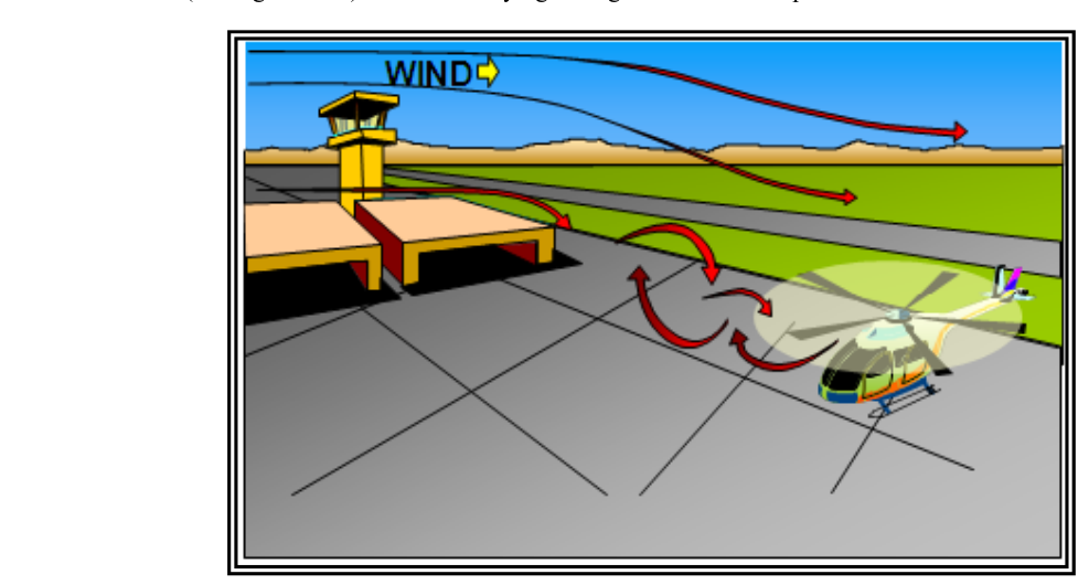
Mechanical turbulence is caused by the disruption of smooth airflow by physical obstacles — terrain, trees, buildings, or any structure that forces the wind to break into eddies as it flows past or over the object. Think of wind flowing around a large rock in a stream: the water downstream swirls chaotically. The same happens to air flowing around a mountain ridge, a row of hangars, or even a line of trees near a runway.
The intensity of mechanical turbulence depends on two factors: wind speed and surface roughness. Faster winds produce stronger eddies; rougher terrain produces more chaotic eddies. In stable air, the eddies are suppressed quickly and the turbulence is weaker but may extend farther downwind in a layered pattern. In unstable air, the eddies mix and grow, creating stronger turbulence close to the obstacle. Mechanical turbulence is especially dangerous in the lee of mountain ridges, where powerful rotors and standing waves can develop. The rotor zone — the area of violently turbulent, recirculating air beneath the crest of a mountain wave — can produce extreme turbulence even in otherwise clear air.
For pilots operating near airports surrounded by trees, buildings, or uneven terrain, mechanical turbulence can affect the approach and landing phase. Wind blowing across a line of hangars upwind of the runway threshold can produce unexpected sink or roll just when the pilot needs a stable, predictable flightpath. Increasing airspeed slightly above normal approach speed in gusty mechanical turbulence conditions is a recommended technique in the Airplane Flying Handbook.
Convective Turbulence
Convective turbulence arises from the vertical movement of air caused by surface heating. When the sun heats the ground, the air in contact with the surface warms and becomes less dense than the air above it. This creates thermals — columns of rising warm air — surrounded by areas of descending cooler air. An aircraft flying through alternating thermals and downdrafts experiences the classic afternoon bumpiness familiar to student pilots flying cross-country on warm summer days.
At its mildest, convective turbulence is a nuisance. At its most extreme, it is found inside convective clouds — cumulonimbus (thunderstorm) cells — where updrafts and downdrafts can exceed 6,000 feet per minute. The FAA is unambiguous: pilots should never enter a thunderstorm. Even near thunderstorms, convective turbulence can be severe; the gust front ahead of a storm can produce sudden, violent wind shear at low altitude, which is catastrophically dangerous during approach or departure. A clearance of at least 20 nautical miles laterally from a severe thunderstorm is a widely cited rule of thumb, and avoiding the anvil — the thunderstorm's high-altitude outflow — is critical because turbulence can extend tens of miles beyond the visible cloud.
Convective SIGMETs (WST) are issued by the Aviation Weather Center whenever thunderstorm activity meets specific thresholds, including lines of thunderstorms, areas of embedded thunderstorms, or any tornado, hail, or wind activity associated with convection. These are mandatory reading for flight planning on convective weather days.
Turbulence Intensity Scale
The FAA defines four official intensity levels for turbulence reporting. Pilots use these levels when filing PIREPs so that other pilots receive standardized, actionable information.
- Light: Slight, erratic changes in altitude or attitude. Occupants may feel slight strain against seat belts. Loose objects remain at rest. Flight time is not affected significantly.
- Moderate: Changes in altitude or attitude occur but the aircraft remains in positive control at all times. Occupants feel definite strain against seat belts. Unsecured objects are dislodged. Food service and walking are difficult.
- Severe: Large, abrupt changes in altitude or attitude. The aircraft may be momentarily out of control. Occupants are forced violently against seat belts. Unsecured objects are tossed about. Food service and walking are impossible.
- Extreme: The aircraft is violently tossed about and is practically impossible to control. It may cause structural damage. Extreme turbulence is rare but possible inside severe thunderstorms and in powerful mountain wave rotors.
A fifth descriptor — chop (light chop or moderate chop) — describes rhythmic bumpiness without significant changes in altitude or attitude. It is reported separately from the four intensity levels above.
Why Intensity Ratings Matter for Safety and Reporting
Accurate PIREPs are one of the most valuable weather products available because they reflect actual conditions rather than forecasted ones. When you encounter turbulence, filing a PIREP through Flight Watch, Flight Service, or ATC is not just courteous — it can directly protect other pilots. A complete turbulence PIREP includes: aircraft type, location, altitude, time, intensity, whether it was in or out of cloud (IMC or VMC), and duration. The FAA AIM outlines the PIREP format in detail.
From a structural standpoint, repeated encounters with even moderate turbulence can cause metal fatigue over time, but the immediate danger of severe or extreme turbulence is a momentary exceedance of the aircraft's design load limits. Flying at or below maneuvering speed (VA) is the recommended technique in turbulence because at or below VA, the aircraft will stall before structural damage occurs from a single full control deflection. Note that VA decreases as the aircraft's weight decreases — the VA published in your POH assumes maximum gross weight.
Key Numbers and Rules
- CAT is most common near the jet stream, typically above 15,000 feet MSL.
- Convective SIGMETs (WST) are valid for up to 2 hours (or 6 hours for outlook SIGMETs).
- AIRMETs Tango cover turbulence, sustained surface winds over 30 knots, and low-level wind shear for aircraft with less-than-jet performance.
- Fly at or below published VA in turbulence; remember that VA is lower at lighter weights.
- Thunderstorm lateral clearance: at least 20 NM from severe cells; avoid the anvil and any overhanging cloud deck.
- Extreme turbulence is the only intensity level that can cause structural damage to a properly maintained aircraft.
Memory Aid
For the three turbulence types, use the simple phrase "C-M-C" — Clear air, Mechanical, Convective. Each "C" or "M" reminds you of the source: atmosphere with no visible cues, physical obstacles, and heat-driven vertical motion. Pair each letter with its characteristic altitude: CAT is high (jet stream level), Mechanical is low (surface obstacles), and Convective is variable (surface to thunderstorm tops). This keeps the three types and their typical altitudes sorted when a test question tries to mix them up.
Common Test Traps
- CAT is always at high altitude — false. Mountain wave activity can produce CAT-like turbulence at lower altitudes on the lee side of ridges, especially in the rotor zone. Do not assume turbulence is absent just because you are below the jet stream.
- Moderate turbulence means loss of control — false. Loss of control is the definition of severe. In moderate turbulence the aircraft remains in positive control, even though it is uncomfortable.
- Flying faster than VA is safer in turbulence — false. Exceeding VA in turbulence risks structural damage, because at higher speeds the aircraft can reach its structural load limit before the wing stalls.
- Convective turbulence only occurs inside clouds — false. Thermals and their associated downdrafts occur in clear air below the cloud bases. Surface heating on a sunny afternoon produces significant convective turbulence even in VMC with no clouds nearby.
- Thunderstorm turbulence is only inside the cell — false. Gust fronts, outflow boundaries, and turbulence in the anvil can extend 20 or more nautical miles from the visible storm. A clear sky near a cumulonimbus does not mean smooth air.