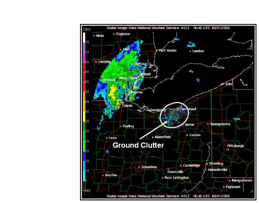
Weather radar is one of the most powerful tools available to pilots and meteorologists, but its images are not always a direct, literal representation of precipitation. Certain atmospheric conditions and physical limitations can produce radar artifacts — false or misleading echoes that do not correspond to actual weather hazards. The three most important artifacts for pilots to understand are ground clutter, anomalous propagation (AP), and the bright band. Misreading these artifacts can lead a pilot to either avoid non-existent weather or, more dangerously, fly toward hazards that radar has hidden or misrepresented.
The FAA Aviation Weather Handbook (FAA-H-8083-28B), Chapter 15, provides a thorough grounding in WSR-88D radar principles. To correctly interpret any radar image — whether from a ground-based NWS WSR-88D network or an aircraft's onboard system — a pilot must first understand how the beam travels through the atmosphere and why it sometimes returns energy from targets that are not rain, snow, or thunderstorms.
How the Radar Beam Travels: Wave Propagation
A radar beam does not travel in a perfectly straight line. Because the atmosphere's density varies with altitude — and horizontally across different air masses — the beam bends, or refracts, as it propagates outward. The key principle is that the beam bends toward the denser, slower-moving portion of the wave. Under standard atmospheric conditions, density decreases gradually with altitude, so the upper portion of the beam travels slightly faster than the lower portion, causing a gentle downward bend. This is called normal (standard) refraction. Even under normal refraction, the beam curves less than the Earth's surface, so the beam's height above the ground increases with range — a critical limitation for detecting low-topped weather at long distances.
Two abnormal refraction conditions create the most significant interpretation problems:
- Subrefraction occurs when atmospheric density decreases with altitude faster than normal. The beam bends less than usual and climbs away from the surface. Distant thunderstorms may be missed entirely, or the beam may strike only the storm's upper portions where precipitation particles are small, causing the storm to appear weaker than it actually is on radar.
- Superrefraction occurs when atmospheric density decreases with altitude slower than normal, or even increases with altitude. The beam bends more strongly toward the Earth's surface than normal. Under extreme superrefraction, the beam can actually strike and follow the Earth's surface — a condition called ducting or trapping. Superrefraction and ducting set the stage for the most significant propagation artifact: anomalous propagation.
Ground Clutter
Under any propagation condition, the lowest radar tilt angles will intercept ground-based targets near the radar site. Buildings, terrain features, towers, trees, and even flocks of birds and insects are legitimate radar targets — they backscatter energy just as precipitation does. The echoes they produce near the radar site are called ground clutter.
Ground clutter typically appears as a roughly circular patch of high-reflectivity returns centered on the radar site, often extending outward 20–30 nautical miles. The returns are stationary, which is the key characteristic distinguishing them from precipitation. The WSR-88D's Doppler velocity processing and clutter-suppression algorithms can filter most ground clutter automatically, but some residual clutter may still appear on base reflectivity products, particularly at the lowest elevation angles. Pilots viewing radar products should be aware that persistent, stationary, high-reflectivity echoes near a radar site — especially in clear conditions — are likely clutter rather than precipitation.
Wind farms and turbines deserve special mention: their rotating blades produce strong, moving returns that can resemble precipitation. These are a known, documented interference source for WSR-88D operations and may appear on radar products even after standard clutter filtering.
Anomalous Propagation (AP)
When superrefraction or ducting occurs, the radar beam is bent sharply downward and intercepts the ground at a much greater range than it would under standard conditions. The ground returns energy back to the antenna, producing anomalous propagation (AP) echoes — false precipitation returns at ranges that can extend hundreds of miles from the radar site.
AP echoes are one of the most commonly misidentified radar artifacts. They can appear as large, irregular, stationary areas of moderate reflectivity that look superficially like widespread stratiform precipitation. The atmospheric conditions that favor AP include strong low-level temperature inversions (warm air over cool air), moisture trapped beneath a dry layer, and stable nighttime radiative cooling — all conditions that increase low-level atmospheric density relative to the layer above.
Several characteristics help distinguish AP from real precipitation:
- AP echoes are stationary or nearly so. Real precipitation moves with the wind. If an echo does not evolve or drift over time, it is suspect.
- AP echoes often appear suddenly at night or near dawn when surface-based inversions are strongest, and dissipate as surface heating mixes the boundary layer.
- AP echoes show near-zero Doppler velocities on velocity products, since ground targets do not move.
- AP echoes frequently appear in the lowest tilt angles only and may disappear entirely when viewing higher-elevation scans of the same area.
- AP echoes are irregular in shape and do not display the organized patterns typical of frontal precipitation or convective lines.
For pilots, the operational risk of AP is misidentifying a large area of false echoes as a significant weather system and making unnecessary diversions, or — conversely — dismissing real precipitation as AP. Cross-referencing radar with pilot reports (PIREPs), METARs, and satellite imagery is essential when AP is suspected.
The Bright Band
The bright band is a radar artifact unique to the melting layer — the altitude at which frozen precipitation (snow and ice crystals) melts into raindrops as it falls through the freezing level. As snowflakes fall into above-freezing air, they become coated with a thin film of liquid water. This water coating makes them appear much larger and far more reflective to radar than either the dry snowflakes above or the raindrops below. The result is a thin horizontal ring or layer of anomalously high reflectivity on radar displays, typically appearing as a band of elevated returns at the altitude of the 0°C isotherm.
The bright band is most commonly observed on radar cross-sections or range-height indicator (RHI) displays, but it can significantly affect plan-view (PPI) products as well. At long ranges from the radar site, the beam's increasing height may intersect the melting layer, causing a false ring of enhanced reflectivity at a specific range. This can mislead a forecaster or pilot into believing that precipitation is more intense at that location than it actually is.
Operationally, the bright band provides useful information: its presence confirms stratiform precipitation (not convective), and its altitude indicates the approximate freezing level, which is directly relevant to icing hazards. However, reflectivity values within the bright band significantly overestimate actual rainfall rates, so quantitative precipitation estimates derived from radar in bright band regions will be inaccurate.
Aircraft Radar vs. WSR-88D: Compounding the Problem
All of the artifact issues described above apply primarily to the ground-based WSR-88D network. Onboard aircraft radar introduces additional limitations that can amplify misinterpretation:
- Aircraft radar operates at a 3-cm wavelength, compared to the WSR-88D's 10-cm wavelength. Shorter wavelengths experience far greater precipitation attenuation — energy is absorbed and scattered by heavy rain before it can reach targets behind the precipitation. Aircraft radar may show only the leading edge of intense storms, hiding severe weather beyond the first line of cells.
- Most aircraft radars have a peak power output of less than 50 kW, versus the WSR-88D's 750 kW. This significantly reduces sensitivity to smaller targets.
- Aircraft radar beam widths typically range from 3° to 10°, compared to the WSR-88D's 0.95°. At 60 NM, two thunderstorms separated by only 5 NM may appear as a single merged echo on aircraft radar, suggesting a gap exists only if the beam is narrow enough to resolve them.
- Most airborne radars compensate for range attenuation only out to 50–75 NM. Beyond that, distant targets appear less intense than they truly are, potentially causing a pilot to underestimate storm severity at greater ranges.
Key Numbers and Rules
- WSR-88D peak power: 750 kW; most aircraft radars: less than 50 kW.
- WSR-88D wavelength: 10 cm; aircraft radar wavelength: 3 cm (more attenuation).
- WSR-88D beam width: 0.95°; aircraft radar beam width: 3°–10°.
- At 60 NM, WSR-88D resolves targets separated by ~1 NM; aircraft radar (5° average) resolves targets separated by ~5.5 NM.
- Aircraft radar range attenuation compensation valid to approximately 50–75 NM; targets beyond appear weaker than actual.
- AP favors conditions with strong low-level temperature inversions, stable nocturnal boundary layers, and moisture beneath a dry layer.
- The bright band marks the 0°C isotherm altitude and indicates stratiform, not convective, precipitation.
Common Test Traps
- Assuming aircraft radar shows the full extent of a storm. Due to precipitation attenuation at 3-cm wavelength, aircraft radar typically displays only the leading edge of extreme echoes. Severe weather may be hidden behind the first line of precipitation.
- Confusing anomalous propagation echoes with real precipitation. AP echoes appear stationary, have near-zero Doppler velocities, and are most pronounced at low elevation angles. They often appear at night when surface inversions are strongest.
- Misidentifying the bright band as convective activity. The bright band is a stratiform feature at the melting layer. It produces artificially high reflectivity values and should not be confused with a line of thunderstorms.
- Ignoring range limitations for aircraft radar. Targets beyond 50–75 NM will appear less intense than they actually are due to uncompensated range attenuation — a critical safety trap when assessing storm severity at distance.
- Assuming a gap in a precipitation line is flyable. At close ranges, improved beam resolution may reveal that an apparent gap in a line was always there but was hidden by the wider beam at greater range. Conversely, apparent gaps on aircraft radar may result from beam-width limitations merging two cells, not an actual opening.