When a large body of air sits over a source region long enough, it takes on the temperature and moisture signature of that surface. Once the air mass begins to move, however, it encounters new surfaces with different properties, and a slow but relentless exchange of heat and moisture begins. Meteorologists call this process air mass modification. Two of its most consequential forms for pilots operating over North America are lake-effect convection and surface heating — phenomena that can transform a benign polar air mass into a snow-producing conveyor belt or convert a dry continental air mass into a thermally unstable afternoon hazard.
Understanding modification mechanics is not merely academic. It directly determines cloud types, precipitation intensity, visibility, icing levels, and turbulence that a pilot will encounter along a planned route. The FAA Aviation Weather Handbook (FAA-H-8083-28B), Chapter 11, establishes the foundational classification system and modification principles that everything else in this article builds upon.
Air Mass Classification: The Starting Point
Before modification can be understood, the original air mass character must be established. The Handbook classifies air masses by two independent properties: temperature (arctic, polar, or tropical) and moisture source (continental or maritime). Combining them yields five operationally significant air masses:
- Continental Arctic (cA) — extremely cold, very dry; forms over snow-covered polar regions, primarily in winter.
- Continental Polar (cP) — cold to cool, dry; originates at high latitudes over land.
- Continental Tropical (cT) — hot, dry; pumped north off the Mexican Plateau, capable of producing drought over the Midwest when stagnant.
- Maritime Polar (mP) — cool, moist; forms over high-latitude ocean surfaces.
- Maritime Tropical (mT) — warm, moist; originates over tropical oceans; dominates Gulf Coast and eastern U.S. summers.
The United States itself is a poor source region because weather systems move through too frequently, preventing any single air mass from stagnating long enough to fully equilibrate with the surface. The moment an air mass leaves its source, modification begins.
The Mechanics of Air Mass Modification
Modification is driven by energy and moisture exchange at the air-surface interface. The direction of that exchange depends on which is warmer — the air or the surface below it — and how much moisture the surface can supply.
Cold air moving over a warm surface: The surface heats the lowest layer of the air mass by conduction and radiation. As the air near the surface warms, its lapse rate steepens, and instability grows from the bottom up. Moisture evaporating from the warm surface adds to the instability. The result is increasing convection: first shallow cumulus, then towering cumulus, and potentially cumulonimbus if the temperature contrast is large enough and the fetch (distance over the warm surface) is long enough. This is precisely the mechanism behind lake-effect snow.
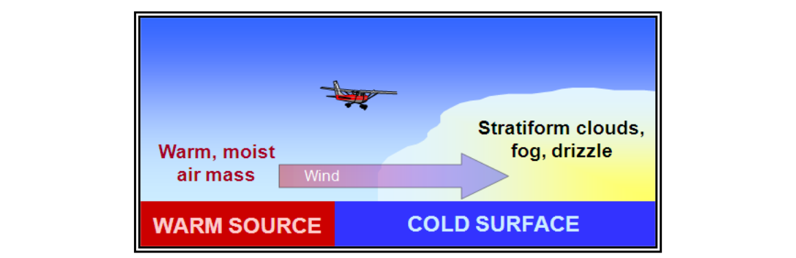
Warm, moist air moving over a cold surface: The opposite process produces the opposite result. The cold surface chills the lowest air layers, increasing stability and suppressing vertical motion. The result is stratiform cloudiness, widespread fog, and drizzle — classically associated with maritime polar air moving onshore or moist tropical air moving over cool ocean currents. The Handbook explicitly illustrates this scenario, noting the stable, layered cloud structure it generates.
Lake-Effect Snow: Cold Air Transformed
Lake-effect weather is the most dramatic wintertime example of cold-over-warm modification in the continental United States. It occurs most prominently over the Great Lakes region and occasionally over the Great Salt Lake in Utah. The Handbook describes it as the effect of any lake in modifying weather near its shores and downwind — with the Great Lakes capable of generating spectacular snowfall amounts on their lee shores.
The mechanism unfolds in several steps during autumn and early winter, before ice cover seals the lake surface:
- A continental polar (cP) or continental arctic (cA) air mass pushes south or southeast out of Canada. This air is initially cold, dry, and stable — characterized by a small temperature-dewpoint spread and suppressed convection.
- As the air crosses the open, relatively warm lake water, the surface heats the lowest air layers from below. Simultaneously, rapid evaporation loads the air with moisture, raising the dewpoint and lowering the lifted condensation level (LCL).
- The combination of surface heating and moisture addition steepens the environmental lapse rate and destroys the original stability. Convective available potential energy (CAPE) builds rapidly.
- Shallow cumuliform clouds — and eventually deeper convective cells — organize into bands aligned roughly parallel to the wind direction. These bands can be tens of miles wide and hundreds of miles long, extending well downwind (to the lee) of the lake.
- When the bands make landfall, orographic lift from terrain features (such as the Tug Hill Plateau east of Lake Ontario) can further enhance snowfall totals, at times producing more than 100 inches in a single event over favored locations.
The Handbook identifies three factors that amplify lake-effect intensity: a larger temperature difference between the warm lake surface and the cold overlying air, higher wind speeds increasing the rate of heat and moisture transfer, and lower relative humidity within the original cold air mass (drier air has more capacity to absorb evaporated moisture before saturation). All three factors tend to peak in November and early December before ice cover develops.
For pilots, lake-effect conditions present a concentrated hazard in a geographically specific area that may look entirely clear just 50 miles upwind. VFR flight into lake-effect snow bands can result in near-zero visibility, low ceilings, and significant airframe icing within minutes. Icing is particularly severe in the lower convective layers where supercooled large droplets are common.
Surface Heating: Daytime Modification Over Land
Even without a lake, simple solar heating of the ground modifies the boundary layer dramatically over the course of a single day. In summer, a cP air mass that was cold and stable at dawn can become genuinely convective by early afternoon as the sun heats the land surface and that energy is mixed upward.
The process is straightforward: the sun heats the surface, the surface heats the contact air layer, thermals carry that heat upward, and the lapse rate in the boundary layer increases. If surface dewpoints are adequate, cumulus clouds form at the LCL. If instability is sufficient and moisture is available, those cumulus cells grow into towering cumulus and eventually cumulonimbus thunderstorms by mid- to late afternoon. This pattern explains why convective activity over the central and eastern U.S. peaks in the mid-afternoon hours on warm summer days — even in air masses that appeared benign at the morning weather briefing.
Surface heating also affects continental tropical (cT) air differently. The cT air mass is already hot and dry; surface heating contributes little additional moisture. The result is high-based convection with limited precipitation and significant clear-air turbulence from strong thermals — a common hazard over the desert southwest and high plains in summer.
Why Air Mass Modification Matters Operationally
A pilot who checks a morning surface analysis chart and identifies an air mass type has only partial information. The critical question is: how has that air mass been modified along its trajectory? An air mass forecast (or trajectory analysis) considers the path the air has traveled and the surfaces it crossed. Ignoring modification leads to significant forecast errors — and potentially dangerous in-flight surprises.
- A cP air mass that has had a long fetch over the Great Lakes is no longer the dry, clear air it was over Manitoba. It carries moisture, convective instability, and snow shower potential.
- An mT air mass moving over the cold Gulf Stream water becomes increasingly stable and foggy — not the convective threat it was over the warm tropics.
- Daytime heating over a dark, dry surface can trigger afternoon thunderstorms in a morning-stable air mass that an unaware pilot dismissed as benign.
Key Numbers and Rules
- Great Lakes lake-effect season: primarily October through January, when lake surfaces remain ice-free and colder air begins to dominate.
- Temperature contrast threshold: a difference of approximately 13 °C (about 23 °F) or more between lake surface temperature and the 850 mb air temperature is a commonly cited threshold for significant lake-effect development (FAA-H-8083-28B context; exact numerical thresholds may vary by source).
- Three amplifying factors (per Handbook): larger temperature difference, higher wind speed, and lower relative humidity in the cold air.
- Stability result — warm air over cold surface: stable air, stratiform clouds, fog, drizzle.
- Stability result — cold air over warm surface: decreasing stability, cumuliform clouds, convective showers or snow squalls.
- Fetch matters: the longer the cold air travels over the warm water, the more heat and moisture it accumulates, and the deeper the convection becomes.
Common Test Traps
- Assuming lake effect requires unstable air to begin with. The original cP or cA air is actually stable — the instability is created by surface heating and moistening over the lake. The exam may phrase a question implying the air was already unstable.
- Confusing the direction of modification effects. Cold air over a warm surface produces instability and cumuliform clouds. Warm, moist air over a cold surface produces stability and stratiform clouds. Students frequently reverse these.
- Thinking lake-effect snow falls over the lake. The most intense snowfall occurs to the lee (downwind) side, after the modified air mass makes landfall and often encounters terrain lift.
- Overlooking afternoon modification. An air mass assessed as stable in a morning briefing may be convectively active by afternoon due to surface heating. Always consider diurnal change when planning afternoon departures or arrivals.
- Misidentifying which lakes produce lake effect. The FAA Handbook specifically names the Great Lakes and the Great Salt Lake in Utah. Only large, relatively deep, ice-free water bodies have sufficient heat capacity to drive the phenomenon.