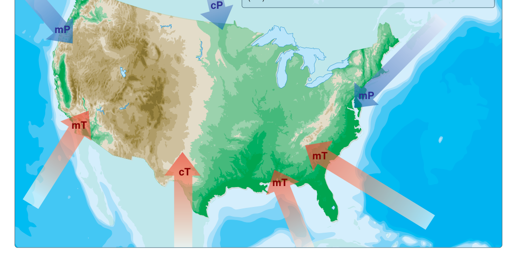
Every significant weather system that affects aviation ultimately traces back to a large body of air that spent enough time sitting over a particular part of Earth's surface to take on that surface's temperature and moisture characteristics. That body of air is called an air mass, and the place where it formed is its source region. Understanding where air masses come from, how meteorologists classify them, and how they change as they travel is one of the most fundamental skills in aviation weather literacy.
The FAA Aviation Weather Handbook (FAA-H-8083-28B), Chapter 11, provides the authoritative treatment of this topic for pilots. Everything that follows is grounded in that guidance.
What Makes a Good Source Region?
For a large, homogeneous air mass to form, air must remain relatively stationary over a surface long enough to absorb the surface's properties through conduction, evaporation, and radiation. Ideal source regions are vast, flat, and uniform—think the Arctic ice cap, the Sahara Desert, or the subtropical Atlantic Ocean. The longer the air stagnates, the more completely it adopts the surface temperature and moisture characteristics below it.
Interestingly, the contiguous United States is not considered a favorable source region. Frequent weather disturbances—fronts, low-pressure systems, and storm tracks—constantly push air masses through before they can fully equilibrate with the surface. As a practical result, the weather over the lower 48 states is heavily influenced by air masses that formed elsewhere and then moved in.
The Two-Axis Classification Scheme
Air masses are classified along two independent axes: temperature (determined by the latitude of the source region) and moisture (determined by whether the source region is land or water). Each axis has its own set of letter codes.
Temperature Designators
- Arctic (A) — An extremely deep, bitterly cold air mass that develops mainly in winter over Arctic ice and snow. It is the coldest of the three thermal categories.
- Polar (P) — A relatively shallow, cool-to-cold air mass that originates over high-latitude continental or oceanic surfaces, but is not as intense as a true Arctic air mass.
- Tropical (T) — A warm-to-hot air mass generated over low-latitude regions where solar heating is intense year-round.
Moisture Designators
- Continental (c) — Develops over land; tends to be dry because there is limited evaporation from a land surface compared to open water.
- Maritime (m) — Develops over ocean or large water bodies; picks up substantial moisture through evaporation and is therefore humid.
Note that these two sets of descriptors are combined using a lowercase letter for moisture and an uppercase letter for temperature. The moisture descriptor always comes first (e.g., mT = maritime Tropical).
The Five Air Mass Types
Combining the temperature and moisture codes produces five operationally recognized air mass types. A sixth combination—Maritime Arctic (mA)—is theoretically possible but seldom if ever forms, because the Arctic source region is almost always covered by ice rather than open water, so it is excluded from standard classification.
- Continental Arctic (cA) — Cold and dry. The most extreme cold-air mass affecting North America. Forms over the Arctic and can plunge southward in winter, bringing dangerously low temperatures and clear, dry conditions. Surface visibility is often excellent when undisturbed, but wind-driven blowing snow can reduce it dramatically.
- Continental Polar (cP) — Cold and dry, though less extreme than cA. Originates over the high-latitude interiors of Canada and Siberia. In winter, cP outbreaks are the classic source of cold waves across the United States. Because the air is dry, icing is less of a concern than with maritime types, but cold temperatures increase the risk of carburetor and induction icing at low power settings.
- Continental Tropical (cT) — Hot and dry. Originates over continental low-latitude deserts such as the Mexican Plateau and the Sonoran Desert. When cT air surges northward into the Great Plains and Midwest and stagnates, it can produce severe drought conditions. Turbulence associated with superheated surface air is a significant low-altitude hazard during summer afternoons in cT environments.
- Maritime Polar (mP) — Cool and moist. Originates over the cold northern oceans—primarily the North Pacific and North Atlantic. On the West Coast, mP air delivers persistent low ceilings, stratus, and fog, particularly in winter. On the East Coast it arrives after modification and can bring significant precipitation. It is the source of much of the persistent instrument-meteorological-conditions (IMC) weather that challenges VFR and IFR pilots alike along U.S. coasts.
- Maritime Tropical (mT) — Warm and moist. Originates over tropical and subtropical oceans, most notably the Gulf of Mexico, the Caribbean Sea, and the subtropical Atlantic and Pacific. This is the dominant warm-season air mass over the eastern two-thirds of the United States. The abundant moisture it carries fuels convective development: afternoon thunderstorms, squall lines, and—when it interacts with cooler air masses—major frontal precipitation events.
Air Mass Modification: How Air Masses Change En Route
Once an air mass leaves its source region, it immediately begins to interact with the new surfaces it travels over. This process is called air mass modification, and it fundamentally alters the weather a pilot can expect.
Consider a winter scenario: a cA air mass forms over the Arctic and begins moving south over the open Atlantic. The ocean surface is far warmer than the Arctic ice, so the bottom of the air mass picks up heat and moisture. By the time it reaches the mid-latitudes, it has warmed and moistened enough to be re-classified as mP—still cold relative to tropical standards, but no longer bone-dry. The lifting of warm surface air into this modified mass can generate cumuliform clouds and showers.
Conversely, a warm, moist air mass (mT) moving northward over a colder land surface loses heat from the bottom up. The lower layers cool toward the dew point, and widespread fog, stratus, and drizzle develop. This is the hallmark of an mT air mass overrunning cooler terrain—a common springtime scenario across the southeastern and central United States. The FAA handbook explicitly notes that a warm, moist air mass moving over a cold surface produces stable air associated with stratiform clouds, fog, and drizzle.
Lake Effect: A Classic Local Modification
One of the most dramatic examples of air mass modification in North America is the lake effect. In autumn and early winter, cold, dry, stable cP or cA air flows southeastward off the Canadian interior and crosses the relatively warm, ice-free Great Lakes. The lake surface heats the lowest layers of the air mass, adds moisture through evaporation, and destabilizes the air. Shallow cumuliform clouds develop, and intense, narrow bands of snow form on the lee side of the lakes—sometimes depositing several feet of snow in a matter of hours while areas only 20 miles away remain clear. The same phenomenon can occur, on a smaller scale, near Utah's Great Salt Lake. For pilots operating in the Great Lakes region from October through January, lake-effect snowbands represent a serious low-level weather hazard with very localized but extremely poor visibility and turbulence.
Why Air Mass Classification Matters for Pilots
Every preflight weather briefing, every METAR, every forecast discussion connects back to what air mass is currently in place and what is replacing it. Knowing the source type tells you whether to expect stable or unstable conditions, dry or moist air, fog or thunderstorms. An mT air mass in July over the Gulf Coast practically guarantees convective activity by afternoon. A cP air mass pushing into the Midwest in January means clear skies and extreme cold, but also a sharp front somewhere on its leading edge where dangerous weather is likely. Identifying the air mass type from surface analysis charts, skew-T diagrams, and area forecasts is a core instrument-pilot skill.
Key Numbers and Rules
- The United States is not a favorable source region—disturbances prevent air masses from stagnating long enough to fully form.
- Five recognized types: cA, cP, cT, mP, mT. Maritime Arctic (mA) is excluded because it rarely if ever forms.
- Continental = dry; Maritime = moist. Arctic = most extreme cold; Polar = cool-to-cold; Tropical = warm-to-hot.
- Warm, moist air moving over a cold surface → stable air, stratiform clouds, fog, and drizzle.
- Cold, dry polar air moving over warm lake water → destabilization, cumuliform clouds, lake-effect snow.
- The longer an air mass sits over its source region, the more completely it takes on that surface's properties.
Common Test Traps
- Confusing cA and cP: Both are cold and dry, but cA is far more extreme and deeper. The exam may ask which is associated with the most severe cold outbreaks—the answer is always cA.
- Forgetting that mA does not exist: Students sometimes try to invent a sixth type. The FAA handbook explicitly states maritime Arctic seldom if ever forms and is not listed as a standard type.
- Mixing up stability effects of modification: Cold, dry air moving over warm water becomes more unstable (lake effect). Warm, moist air moving over a cold surface becomes more stable (fog and stratus). These two scenarios are frequently swapped on knowledge tests.
- Assuming cT brings thunderstorms: Continental Tropical air is hot and dry—it suppresses convection unless it mixes with a moisture source. Thunderstorm fuel comes from mT air, not cT air.
- Thinking the U.S. produces its own air masses: The contiguous United States imports its air masses; it does not generate them because weather disturbances prevent stagnation.