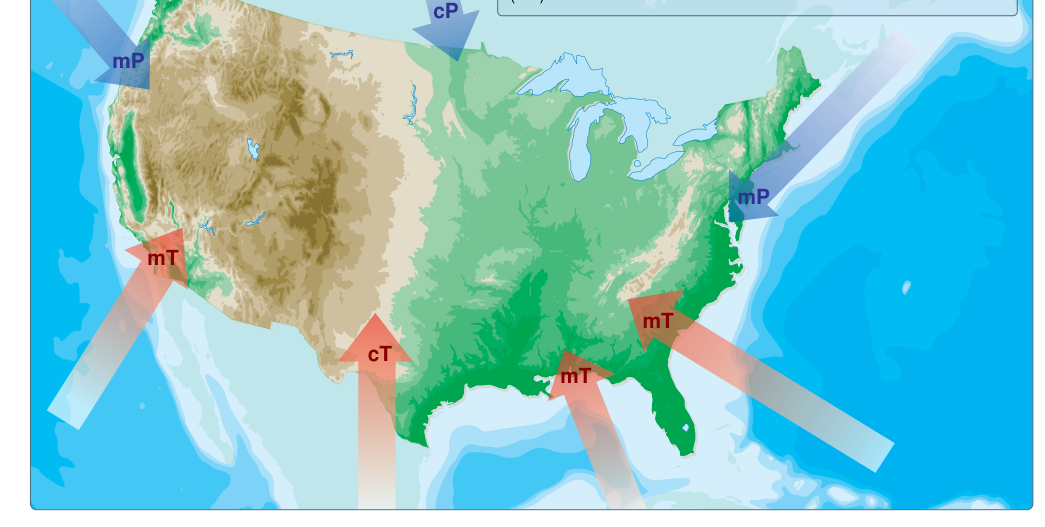
Every significant weather event a pilot encounters — from a clear, smooth ride at altitude to a violent thunderstorm — can ultimately be traced back to the nature of the airmass overhead. An airmass is a large body of air, often covering hundreds or even thousands of miles, that has relatively uniform temperature and moisture characteristics throughout its horizontal extent. These characteristics are acquired from the surface over which the airmass forms and lingers, a geographic area called the source region. Once an airmass departs its source region, it carries those properties with it — modifying the weather of every area it crosses. For a student pilot, understanding how airmasses are classified and where they come from is the foundation of reading any weather briefing with genuine comprehension.
The FAA Pilot's Handbook of Aeronautical Knowledge (PHAK) treats airmass theory as essential background knowledge because it explains why certain regions of the country experience characteristic weather patterns at different times of year, why some days are hazy and humid while others are crystal clear, and why visual flight rules (VFR) conditions can deteriorate dramatically when one airmass is replaced by another. The concepts are also heavily tested on the FAA Private Pilot Knowledge Exam, so investing time here pays double dividends.
What Makes a Good Source Region
For an airmass to develop its uniform properties, it must stagnate — remain relatively stationary — over a large, flat, and homogeneous surface for days to weeks. Ideal source regions are large, flat, and uniform surfaces — such as oceans, deserts, and polar plains — where air can settle and remain in contact with the surface long enough to take on its temperature and moisture characteristics through radiation, conduction, and evaporation; this stagnation is often supported by large, stable high-pressure systems (anticyclones), though the defining trait of a good source region is the uniformity of the underlying surface itself. Rough, mountainous terrain does not make a good source region because it produces too much local variation. The best source regions are the subtropical ocean gyres, the polar ice caps and tundra, and the broad continental interiors.
The Classification System
Meteorologists classify airmasses using a two-part system based on latitude (temperature) and surface type (moisture). The latitude-based designators are:
- Arctic (A) — forms over the arctic ice cap and polar tundra; bitterly cold and very dry.
- Polar (P) — forms over high-latitude land or ocean surfaces, roughly 50°–60° N or S; cold and relatively dry over land, cold and moist over ocean.
- Tropical (T) — forms over low-latitude subtropical regions; warm to hot.
The surface-type designators indicate moisture content:
- Continental (c) — forms over land; generally drier (lower dew points).
- Maritime (m) — forms over ocean or large water bodies; generally moister (higher dew points).
Combining these gives the four principal airmass types that affect North American aviation weather:
- continental Polar (cP) — cold, dry, stable; originates over Canada and Alaska.
- maritime Polar (mP) — cold, moist, and generally more stable in its lower layers, though surface heating from relatively warm water can induce shallow instability near the surface; typically produces stratus, fog, and drizzle; originates over the north Pacific or north Atlantic oceans.
- continental Tropical (cT) — hot, dry, with instability generally confined to the surface and lower layers due to intense heating; originates over the Mexican plateau and the desert southwest.
- maritime Tropical (mT) — warm, moist, and conditionally unstable; originates over the Gulf of Mexico, Caribbean Sea, and subtropical Pacific.
A fifth type, continental Arctic (cA), is sometimes listed separately from continental Polar to distinguish the most extreme cold-air outbreaks that originate directly over the Arctic ice cap.
How Source Regions Influence Weather
continental Polar (cP) Airmasses
The cP airmass is the workhorse of North American cold-weather events. Forming over the cold Canadian interior or Alaska, these airmasses arrive with low temperatures, low dew points, and excellent visibility — often unlimited once any frontal cloudiness clears out. The air is stable in the sense that it does not readily produce convective thunderstorms on its own. However, when a cP airmass moves rapidly southward in winter, it can sweep frontal systems along and bring dramatic temperature drops. Pilots typically enjoy excellent VFR flying in the core of a cP airmass, but icing can be a serious hazard in any clouds that form because the temperatures are often in the most dangerous icing range.
maritime Polar (mP) Airmasses
The mP airmass is the primary weather-maker for the Pacific Northwest and New England. Cold and laden with oceanic moisture, mP air tends to be more stable in its lower layers, producing the stratus, fog, and drizzle typical of a marine layer, though surface heating from the relatively warm ocean can induce shallow instability near the surface, particularly in winter. On the West Coast, mP air that crosses the Pacific picks up enormous moisture content and produces persistent low ceilings, fog, and heavy orographic precipitation as it rises over the Coast Ranges and Cascades. On the East Coast, mP air that has traversed the Atlantic produces similar stratus and fog conditions. Pilots operating in mP environments should expect low ceilings and reduced visibility even when no frontal system is present.
maritime Tropical (mT) Airmasses
The mT airmass is arguably the most dangerous for pilots in the continental United States because it is the primary fuel source for convective weather. Warm, moist air from the Gulf of Mexico flows northward ahead of cold fronts across the central and eastern US, loading the atmosphere with the instability and moisture needed to produce severe thunderstorms, tornadoes, and widespread instrument meteorological conditions (IMC). Even without lifting mechanisms, mT air produces haze, restricted visibility in mist or fog, and low stratus decks — especially overnight and in the early morning. mT air over the Gulf states often carries high dew points in summer, meaning relatively little cooling is required for fog or low clouds to form.
continental Tropical (cT) Airmasses
The cT airmass forms over the desert southwest and northern Mexico in summer. It is hot and very dry at the surface, which means surface-based fog and stratus are rare. Intense surface heating creates instability that is generally most pronounced near the surface and in the lower layers. When moisture is entrained — such as during the North American Monsoon — explosive convective development can occur, producing severe afternoon thunderstorms with little warning. Dust storms (haboobs) are also associated with cT airmass conditions ahead of convective outflow boundaries.
Airmass Modification
An airmass does not remain static once it leaves its source region. As it travels, it is continuously modified by the new surfaces beneath it. A cP airmass moving south over the Great Lakes in autumn picks up enormous amounts of heat and moisture from the relatively warm lake surfaces — a process that produces the infamous lake-effect snow squalls downwind of Lakes Erie and Ontario. Similarly, an mT airmass pushing northward in winter loses moisture as it cools, and its clouds and precipitation diminish. The key concept for pilots is that airmass characteristics are most extreme near the source region and become increasingly modified with distance and time of travel.
Key Numbers and Rules
- An airmass is defined as a body of air covering hundreds to thousands of miles with nearly uniform temperature and moisture at any given altitude.
- The four main types for North America: cP, mP, cT, and mT (plus cA for extreme arctic outbreaks).
- The lowercase letter (c or m) indicates moisture/surface type; the uppercase letter (P, T, or A) indicates temperature/latitude.
- mT airmasses — warm, moist Gulf air — are the leading contributor to convective weather and IMC across the eastern two-thirds of the US.
- cP airmasses — cold, dry Canadian air — typically bring excellent VFR visibility but significant icing potential in clouds.
- Lake-effect snow is produced when a cold cP airmass passes over relatively warm Great Lakes water, gaining heat and moisture in its lowest layers.
- The stability of an airmass determines the type of clouds and precipitation: stable airmasses produce stratus clouds and steady precipitation; unstable airmasses produce cumuliform clouds and showery precipitation.
Common Test Traps
- Confusing letter order: The FAA exam may use the notation cP or mT and ask you to decode it. Remember — surface type (c or m) is lowercase and written first; latitude/temperature class (A, P, or T) is uppercase and written second.
- Assuming cP means no weather hazard: A cP airmass brings great visibility but also carries severe icing potential in clouds and can support snow squalls over the Great Lakes. Don't assume cold and dry means safe in all respects.
- Misidentifying the source of US thunderstorm fuel: The exam frequently expects you to know that maritime Tropical (mT) air from the Gulf of Mexico is the primary moisture source for severe convective weather over the continental US — not continental Tropical air.
- Forgetting airmass modification: The FAA may describe an airmass that has traveled far from its source region and ask about its current properties. Remember that modification by the underlying surface can significantly change temperature and moisture characteristics over time.
- Stable vs. unstable clouds: The exam tests whether you know that stable airmasses produce stratus-type (layered) clouds with steady drizzle or rain, while unstable airmasses produce cumulus-type (vertical development) clouds with showery or convective precipitation — a classic question paired with airmass type identification.