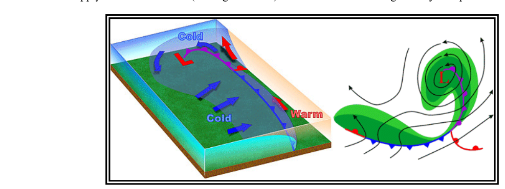
Two of the most important concepts in mid-latitude weather are the wave cyclone model and the dryline. Together they explain how large storm systems are born and sustained, and why certain parts of the United States — especially the central and southern Plains — experience some of the most violent weather on Earth. Pilots operating in or near these features face hazards that range from widespread IMC and icing to embedded thunderstorms and tornadoes. Understanding the life cycle of a wave cyclone and the behavior of the dryline is therefore essential knowledge for any certificate or rating that involves cross-country or instrument flight.
Both topics are addressed in detail in the FAA Aviation Weather Handbook (FAA-H-8083-28B), Chapter 11, which covers air masses, fronts, and the wave cyclone model. This article expands on those concepts and connects them to practical pilot decision-making.
How the Wave Cyclone Model Works
A wave cyclone is a large low-pressure circulation that forms and moves along a pre-existing frontal boundary. It should not be confused with a tornado — the two phenomena are entirely different in scale and mechanism. Wave cyclones are the primary weather producers across the mid-latitudes. They typically travel from west to east, can span hundreds to thousands of miles, and may persist from a few days to more than a week. Their evolution follows a predictable five-stage life cycle.
Stage 1 — The Stationary Front
Everything begins with a stationary front: a boundary separating a cold air mass to the north from a warm air mass to the south, with little net movement in either direction. At this stage the atmosphere is essentially in a holding pattern, but instabilities in the flow aloft can quickly set the process in motion.
Stage 2 — Wave Formation
A low-pressure disturbance, often triggered by an upper-level trough or jet-stream divergence, causes a characteristic kink or wave to develop along the front. Winds on both sides of the front begin to circulate counterclockwise (in the Northern Hemisphere) around the new low-pressure center. The front is now divided into a cold front trailing to the southwest and a warm front extending to the northeast. Precipitation appears, with the heaviest intensity concentrated along the zones of frontal lift.
Stage 3 — Intensification
As the wave deepens, both the cold and warm fronts become better organized. The cold front advances southward and eastward while the warm front pushes northward. The region of warm, moist air sandwiched between the two fronts — called the warm sector — is clearly defined at the surface. The pressure at the center continues to drop, tightening pressure gradients and increasing wind speeds.
Stage 4 — Maturity and Occlusion
Cold fronts move faster than warm fronts. In the mature stage, the cold front overtakes the warm front at the surface, and an occluded front forms. The cold air undercuts the retreating cooler air ahead of the warm front, pushing the warm sector aloft. Clouds and precipitation occur along, ahead of, and behind the surface position of the occluded front. Pilots should expect warm-front-type weather as the occlusion approaches (broad area of stratus, low ceilings, steady rain or snow), immediately followed by cold-front-type weather (convective activity, shifting winds, rapid pressure rise) as it passes.
There are two varieties of occluded front. In a cold-front occlusion, the air behind the cold front is colder than the cool air ahead of the warm front. The cold air undercuts and replaces the cool air, forcing the warm front aloft. Weather is typically a mixture of both front types; if the air is relatively stable, conditions are manageable but still IFR-capable. In a warm-front occlusion, the air ahead of the warm front is actually colder than the air behind the advancing cold front. In this case the cold front rides up and over the warm front. If the air forced aloft is unstable, the result is more severe: embedded thunderstorms, rain, and fog are all likely, making this scenario particularly hazardous for IFR flight.
Stage 5 — Dissipation
As occlusion continues, the supply of warm, moist air feeding the system is gradually cut off. Without the energy source of the warm sector, the low weakens and eventually dissipates. The entire life cycle — from stationary front to dissipating occluded low — may span only a few days, underscoring how quickly the weather can change over a large region.
The Dryline
While the wave cyclone model describes the vertical and horizontal structure of frontal storms, the dryline is a different kind of boundary altogether. It is not defined primarily by temperature but by moisture content. A dryline is a low-level boundary, often hundreds of miles long, that separates a moist air mass from a dry air mass.
In the United States, the dryline typically runs north-south across the southern and central High Plains during spring and early summer. To its east lies moist maritime tropical (mT) air streaming northward from the Gulf of Mexico. To its west lies hot, dry continental tropical (cT) air originating over the desert southwest. The sharp contrast in dewpoint across the dryline can exceed 30°F over a horizontal distance of just a few miles — a dramatic change in atmospheric moisture that has profound weather implications.
Daily and Seasonal Movement
The dryline has a characteristic diurnal cycle. During the afternoon, solar heating mixes down dry air from above and the boundary advances eastward across the Plains. Overnight and in the morning, mixing ceases, the boundary retreats westward, and low-level clouds and fog may form in the moist air on the eastern side. However, a strong wave cyclone can override this diurnal pattern entirely and sweep the dryline rapidly eastward into the Mississippi Valley or beyond, regardless of the time of day.
Weather Associated with the Dryline
The dryline is one of the most prolific triggers for severe and tornadic thunderstorms in the world. When the moist, unstable Gulf air is forced to rise along the dryline boundary — particularly as the dryline surges eastward in the afternoon — Convective Available Potential Energy (CAPE) values can be enormous, and capping inversions that had suppressed convection all morning can suddenly break. The result is explosive thunderstorm development along or just east of the dryline. These storms frequently become supercells capable of producing large hail, damaging winds, and tornadoes.
A typical dryline passage brings the following changes in rapid succession: a sharp drop in relative humidity (and dewpoint), clearing skies, a wind shift from southerly or southeasterly to westerly or southwesterly, rising temperatures, and possibly blowing dust. When the dryline retreats westward overnight, these changes occur in reverse — humidity rises, winds back to the south, clouds and fog return on the moist side.
Why These Concepts Matter to Pilots
The wave cyclone model explains why weather systems across the continental United States follow recognizable patterns. By knowing which stage of cyclone development is occurring, a pilot can anticipate whether conditions ahead will be improving or deteriorating, and what type of frontal weather to expect. For example, a mature wave cyclone with an occluded front approaching from the west is a reliable signal that extended IMC, possible icing, and in the case of a warm-front occlusion, embedded thunderstorms are likely. Pre-flight planning should include verifying the stage of any nearby cyclone and projecting its movement over the intended route and time of flight.
The dryline demands equal respect. Because it lacks the dramatic temperature contrast of a cold front, pilots sometimes underestimate it. Yet the convective potential along an advancing dryline can be equal to or greater than that along a classic cold front. Any springtime flight across the southern Plains should include a check for dryline position and movement. If the dryline is advancing eastward and soundings indicate steep lapse rates with a broken cap, severe thunderstorm development is imminent.
Key Numbers and Rules
- Wave cyclone duration: typically a few days to more than a week.
- Wave cyclone movement: generally west to east across the mid-latitudes.
- Cold-front occlusion: cold air behind the front is colder than the cool air ahead of the warm front; the cold air undercuts and replaces cool air; mixed frontal weather results.
- Warm-front occlusion: air ahead of the warm front is colder than air behind the cold front; the cold front rides up and over; unstable air produces embedded thunderstorms, rain, and fog — more severe than cold-front occlusion.
- Dryline location: north-south orientation across the southern and central High Plains; mT air to the east, cT air to the west.
- Dryline diurnal cycle: advances eastward in the afternoon, retreats westward overnight.
- Dryline passage signature: sharp dewpoint drop, wind shift to westerly/southwesterly, clearing skies, rising temperatures, possible blowing dust.
Common Test Traps
- Confusing wave cyclone with tornado: The FAA handbook explicitly notes these are different. A wave cyclone is a large, multi-day low-pressure system; a tornado is a violent, small-scale vortex. Do not equate the two.
- Thinking cold-front occlusion is more severe than warm-front occlusion: It is actually the opposite. A warm-front occlusion, when the lifted air is unstable, produces embedded thunderstorms, rain, and fog — more severe conditions than the mixed but comparatively manageable weather of a cold-front occlusion.
- Overlooking the dryline's severe weather potential: Exam questions may ask which boundary triggers severe thunderstorms; the dryline is the correct answer in the Plains context, even though it lacks the temperature contrast of a classic front.
- Assuming the dryline only moves eastward during the day: While the diurnal cycle is typical, a strong wave cyclone can force the dryline east at any time of day — a nuance that catches students who memorize only the general rule.
- Misidentifying occlusion weather timing: As an occluded front approaches, warm-front weather prevails first, then cold-front weather follows immediately after passage — in that order, not simultaneously or in reverse.