Every cloud in the sky owes its existence to a simple physical principle: when air rises, it enters a region of lower atmospheric pressure, expands, and cools — without exchanging heat with its surroundings. That process is called the adiabatic process, and mastering it unlocks a pilot's ability to predict cloud bases, thunderstorm development, mountain weather, and the behavior of air masses on both sides of a ridge. The FAA Aviation Weather Handbook (FAA-H-8083-28B), Chapter 12, treats this subject as the foundation of all cloud and stability analysis, and this article walks through every layer of it.
The word adiabatic literally means "no heat transfer." Because air is a poor thermal conductor, a parcel of air moving vertically exchanges negligible heat with the surrounding atmosphere during the brief time it takes to ascend or descend. Instead, all temperature changes result from internal energy changes driven by pressure changes — expansion cools the parcel; compression warms it. This distinction is critical: the temperature change is not caused by mixing with warmer or cooler air, but by the physics of an expanding or compressing gas.
The Dry Adiabatic Lapse Rate (DALR)
When an unsaturated parcel of air — one with a relative humidity below 100 percent — is lifted, it expands and cools at the dry adiabatic lapse rate (DALR) of approximately 3 °C per 1,000 ft (9.8 °C per km). Simultaneously, the parcel's dewpoint decreases at a much slower rate of 0.5 °C per 1,000 ft. Because the temperature drops faster than the dewpoint, the temperature-dewpoint spread narrows with altitude, and relative humidity rises.
This process is fully reversible for an unsaturated parcel. If the same parcel descends without reaching saturation, it compresses and warms at exactly the same rate — 3 °C per 1,000 ft — while its dewpoint rises at 0.5 °C per 1,000 ft. The spread widens again, and relative humidity falls. No net change in water vapor content occurs during this up-and-down cycle.
The Lifted Condensation Level (LCL) and Cloud Base
As an unsaturated parcel rises, it eventually reaches the altitude where temperature equals dewpoint and relative humidity hits 100 percent. That altitude is the Lifted Condensation Level (LCL) — the level at which condensation begins and cloud base forms. A practical formula for estimating the LCL is widely used: divide the surface temperature-dewpoint spread (in °C) by 2.5, and the result is the approximate cloud base in thousands of feet AGL. For example, a surface temperature of 18 °C and a dewpoint of 13 °C yields a spread of 5 °C; 5 ÷ 2.5 = 2, so the LCL is approximately 2,000 ft AGL. The FAA handbook confirms this arithmetic with exactly this example.
The Moist Adiabatic Lapse Rate (MALR)
Once the parcel reaches its LCL and saturation begins, something important changes: condensation releases latent heat into the parcel. That added warmth partially offsets the cooling from expansion, so the parcel now cools at a slower rate — the moist adiabatic lapse rate (MALR). The MALR is not a fixed value; it ranges from about 1.2 °C per 1,000 ft for very warm saturated air to as much as 3 °C per 1,000 ft for very cold saturated air. The FAA handbook uses 2 °C per 1,000 ft as a standard simplification for worked examples.
Why does the MALR vary with temperature? Warm air can hold far more water vapor than cold air, so a warm saturated parcel releases more latent heat during condensation, slowing the cooling rate more dramatically. A cold saturated parcel contains little moisture to condense, releases little latent heat, and therefore cools at a rate approaching the DALR.
Above the LCL, the parcel's dewpoint decreases at the same rate as its temperature — both change at the MALR — because water vapor is being continuously removed from the air by condensation into cloud droplets and ice crystals. Cloud condensation nuclei (CCN) — microscopic particles of dust, clay, soot, sulfate, and sea salt — provide the surfaces on which condensation and deposition occur. Without CCN, air could become supersaturated without forming a cloud; in practice, the atmosphere is rarely short of nuclei.
Descending Saturated Air: Rapid Drying
A saturated parcel that begins to descend immediately becomes unsaturated because compression warms it faster than it can remain at 100 percent relative humidity. Once it drops below saturation, it descends at the DALR (3 °C per 1,000 ft warming) with the dewpoint rising at only 0.5 °C per 1,000 ft. The end result: air that descends after previously rising through saturation arrives at a lower altitude warmer and drier than it was when it started the ascent. The orographic (mountain) example in the FAA handbook is the clearest illustration of this effect.
Common Sources of Vertical Motion
The adiabatic processes described above are set in motion by four primary lifting mechanisms recognized in FAA-H-8083-28B, Chapter 12:
- Orographic lift: Terrain forces air upward along windward slopes. Cooling promotes cloud and precipitation development above the LCL. On the leeward slope, descending air warms and dries, creating a rain shadow that can extend hundreds of miles downwind. The Pacific Northwest's Cascade Range is a classic example — lush, rainy western slopes vs. semiarid eastern terrain.
- Frontal lift: At a frontal boundary, less-dense air is forced aloft over denser air. Both warm fronts (shallow, widespread lift) and cold fronts (steeper, more intense lift) drive air through the adiabatic cooling process, producing the characteristic cloud and precipitation patterns pilots study for IFR planning.
- Frictional (convergence) effects: Surface friction causes winds to spiral inward toward low pressure in the Northern Hemisphere. This convergence forces air upward. Conversely, winds diverge outward from high pressure, causing air to sink, compress, warm, and suppress cloud development.
- Buoyancy (convective lift): When the surface is heated unevenly, pockets of warmer air become less dense and rise as thermals. This is the engine of convective clouds, cumulus development, and ultimately thunderstorms when sufficient moisture and instability are present.
Why It Matters for Pilots
Every practical preflight weather assessment relies on these principles. Estimating cloud bases from the temperature-dewpoint spread helps a VFR pilot judge whether terrain clearance is achievable. Understanding the LCL and MALR helps instrument pilots anticipate icing levels and the height of embedded cumulonimbus within stratiform cloud layers. Recognizing the drying effect of descending air explains why lee-slope airports can be simultaneously clear and turbulent, and why a foehn or chinook wind brings dramatic temperature and humidity changes in minutes.
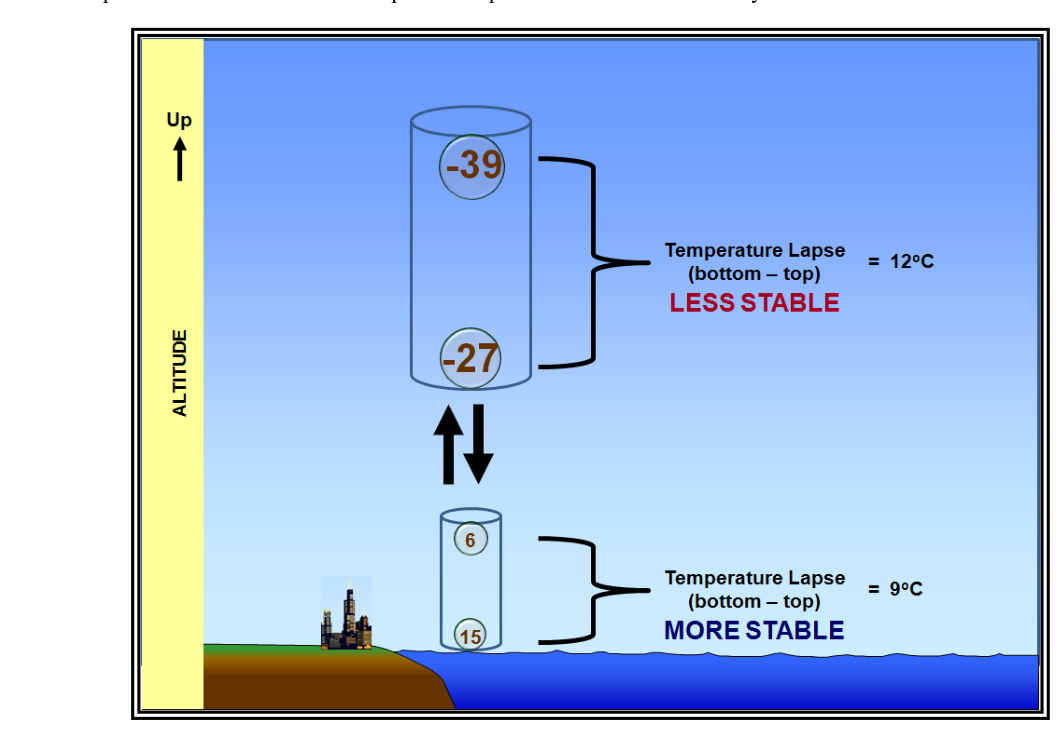
Atmospheric stability — the key to distinguishing smooth stratus from explosive convection — is directly tied to comparing the environmental lapse rate to the DALR and MALR. When the environmental temperature decreases with altitude faster than the DALR, the atmosphere is absolutely unstable; a displaced parcel is always warmer than its environment and accelerates upward. When the environmental lapse rate falls between the MALR and DALR, the atmosphere is conditionally unstable — stable for dry parcels, unstable for saturated ones. This conditional instability is the setup for towering cumulus and thunderstorm development when moisture is sufficient and a trigger (orographic, frontal, or convective) provides the initial lift.
Key Numbers and Rules
- Dry Adiabatic Lapse Rate (DALR): Temperature decreases 3 °C per 1,000 ft for rising unsaturated air; increases 3 °C per 1,000 ft for descending unsaturated air.
- Dewpoint change (unsaturated): 0.5 °C per 1,000 ft (decreases when rising, increases when descending).
- Moist Adiabatic Lapse Rate (MALR): 1.2 °C to 3 °C per 1,000 ft; FAA handbook standard example uses 2 °C per 1,000 ft.
- Dewpoint change (saturated): Identical to MALR — temperature and dewpoint change at the same rate above the LCL.
- LCL cloud base estimate: Spread (°C) ÷ 2.5 = cloud base in thousands of feet AGL.
- Relative humidity above LCL: Remains approximately 100 percent throughout ascent.
- Descending saturated parcel: Immediately becomes unsaturated; warms at DALR; arrives at lower altitude warmer and drier than before lift began.
Memory Aid
A widely used memory aid for lapse rates is "Three and a Half" (3 / 0.5 / MALR varies): 3 °C per 1,000 ft for temperature (dry), 0.5 °C per 1,000 ft for dewpoint (always), and the moist rate is always less than 3 because latent heat offsets cooling. Some instructors pair this with the phrase "Dry Three, Wet Less" to distinguish the DALR from the MALR at a glance.
Common Test Traps
- Confusing the DALR with the environmental lapse rate (ELR): The DALR (3 °C/1,000 ft) is the rate at which a rising parcel cools, not the rate the surrounding atmosphere is already changing. The ELR is measured by soundings and varies widely; the DALR is a fixed physical constant for unsaturated air.
- Forgetting that the MALR varies: Test questions sometimes present the MALR as a single fixed value. It ranges from 1.2 to 3 °C/1,000 ft; the FAA uses 2 °C/1,000 ft only as a simplified example, not an absolute constant.
- Assuming descending saturated air stays saturated: A saturated parcel descending even a small distance immediately becomes unsaturated and switches to the DALR (3 °C/1,000 ft warming), not the MALR. Missing this switch leads to large errors in calculating surface temperature after mountain crossing.
- Mixing up how dewpoint changes above the LCL: Below the LCL, dewpoint and temperature change at different rates (0.5 vs. 3 °C/1,000 ft). Above the LCL, they change at the same rate (both at the MALR), because condensation removes water vapor from the air at the same pace as temperature drops.
- Reversibility confusion: The adiabatic process is reversible only if the parcel remains unsaturated throughout. Once condensation occurs and water is rained out, the process is no longer reversible — the parcel carries less moisture on descent and arrives at the base warmer and drier, a fact that the rain-shadow orographic example explicitly demonstrates.