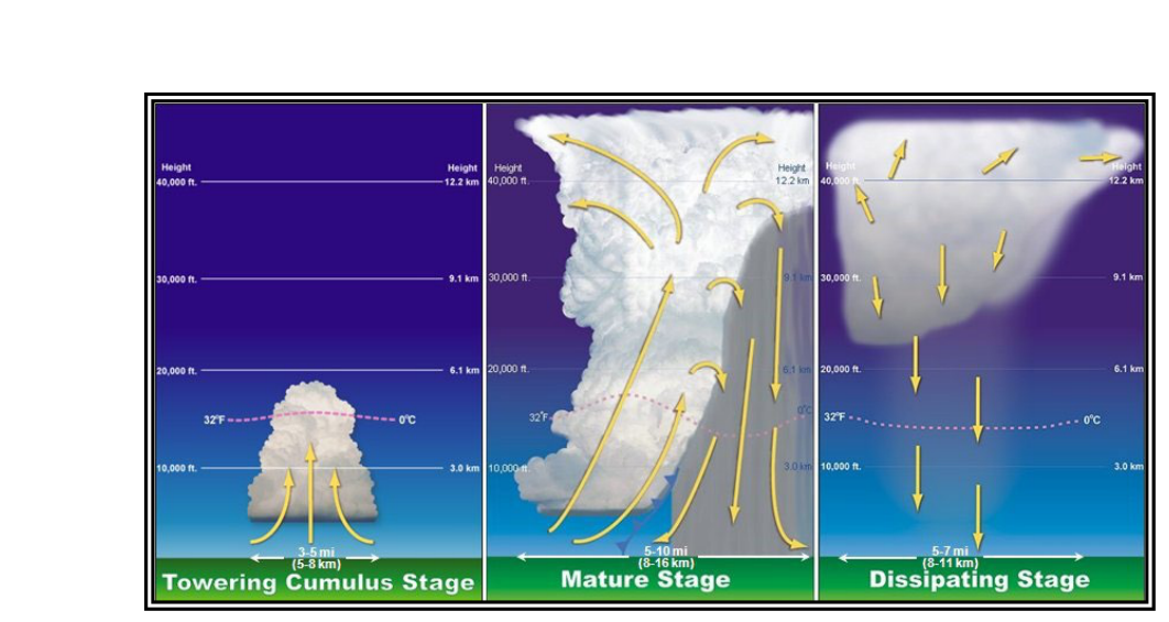
Every thunderstorm, from a brief summer pop-up to the most violent supercell, begins with the same raw ingredients and moves through the same three-stage life cycle. Understanding exactly what is happening inside the cloud at each stage — and why — is not merely an academic exercise. It directly determines where the worst hazards are concentrated, how fast conditions can change, and why even a storm that appears to be "dying" can still kill. The FAA Aviation Weather Handbook (FAA-H-8083-28B), Chapter 22, is the authoritative source for this material and the basis for nearly every written-test question on the subject.
Before the life cycle can begin, three ingredients must be present simultaneously: sufficient water vapor (often assessed by dewpoint), unstable air (almost always conditionally unstable), and a lifting mechanism to release that instability. Lifting mechanisms include surface fronts, converging winds around lows and troughs, upslope flow, drylines, sea and valley breezes, and outflow boundaries from prior storms. Remove any one ingredient and cell development stalls. Add all three in abundance and a thunderstorm cell is essentially inevitable.
Stage 1: The Towering Cumulus Stage
The towering cumulus stage is defined by a single dominant feature: a strong convective updraft. A bubble of warm, buoyant air accelerates upward and concentrates near the cloud top, leaving a cloudy trail below it as moisture condenses in the rising air. Updraft speeds during this stage can exceed 3,000 feet per minute (fpm). Because the updraft is so vigorous, precipitation particles — raindrops and ice crystals — are continuously lofted back into the cloud before they can fall. This means no rain is reaching the surface yet, which is the critical marker that separates this stage from what comes next.
From the outside, the pilot sees a rapidly building cumulus tower with sharp, cauliflower-like edges and a crisp top that may already be punching into high altitudes. The cloud appears brilliant white because the updraft is constantly refreshing the cloud with new condensate. Turbulence is already severe in and near the updraft, but the full arsenal of thunderstorm hazards has not yet been unleashed. Crucially, there is no lightning yet — the charge separation that produces lightning requires the mix of updraft and downdraft that comes in the next stage.
Stage 2: The Mature Stage
The transition from towering cumulus to mature is marked by one observable event: precipitation reaching the surface. As precipitation particles grow heavy enough to fall despite the updraft, they drag surrounding air downward, creating a strong downdraft that exists alongside the still-active updraft. This simultaneous updraft and downdraft coexistence is the hallmark of the mature stage and is the reason it is, by far, the most dangerous.
The downdraft spreads outward when it hits the surface, racing well ahead of the parent storm as a mass of cool, gusty air. The arc-shaped leading edge of this spreading cold air is called the gust front. The FAA handbook describes it as resembling a miniature cold front. Surface observers experience a sudden, dramatic wind shift and temperature drop as the gust front passes — often before they can even see the storm itself. The gust front's forced uplift can trigger new cell formation sometimes many miles ahead of the original cell, which is one reason thunderstorm complexes grow and persist far longer than a single 30-minute life cycle.
Meanwhile, the cumulonimbus top frequently penetrates into the lower stratosphere as an overshooting top. The stable stratospheric air resists further upward growth and strong winds aloft shear the cloud top outward into the iconic flat, spreading anvil shape. Anvils can extend hundreds of miles downwind — and occasionally even upwind — from the parent storm. Pilots who think they are safely clear of a storm because they are flying near the anvil are still within range of severe icing, hail ejected from the top of the updraft, and clear-air turbulence.
Weather hazards reach peak intensity toward the end of the mature stage. This includes the worst turbulence (both updraft and downdraft in close proximity), the heaviest rain and hail, the greatest lightning frequency, and, if conditions support it, tornadoes and microbursts. A microburst — a particularly intense concentrated downdraft — can produce a wind shear encounter severe enough to exceed the structural or performance limits of virtually any aircraft at low altitude.
Stage 3: The Dissipating Stage
The dissipating stage begins when the downdraft dominates and subsiding air replaces the updraft throughout the cloud. This is the storm's self-destruction mechanism: the same downdraft that created spectacular weather now cuts off the moist inflow that was feeding the storm. Without fresh moisture from below, the storm's energy source is gone.
As air subsides, it compresses and warms adiabatically. Relative humidity drops, precipitation tapers off and eventually ends, and the sharp, cauliflower edges of the cumulonimbus gradually soften and evaporate from below. What remains is often just a remnant anvil cloud — a thin, fibrous cirrus-like shield that can linger for hours after the convective activity has ceased.
A critically important operational point: the dissipating stage is not a safe stage to fly through. The downdraft embedded within the precipitation area is still strong and capable of producing severe turbulence, icing, and wind shear. The visible storm may look less imposing — no more towering top, reduced lightning — but the hazards inside the precipitation area remain very real until the cloud fully dissipates.
Why the Life Cycle Matters Operationally
A single-cell thunderstorm completes the entire three-stage life cycle in roughly 30 minutes. This has profound implications for flight planning and in-flight decision-making. A storm that appears to be in the towering cumulus stage when you check the radar could be in its most dangerous mature stage by the time you arrive. Equally, a storm that looks like it is dissipating on a radar picture that is 10–15 minutes old may still be in the late mature stage with its worst hazards intact.
Multicell cluster and line thunderstorms exploit the life-cycle mechanics to achieve longevity far beyond 30 minutes. As one cell matures and is carried downwind by upper-level winds (advection), a new cell forms upwind — often triggered by the original cell's own gust front — to take its place. This propagation cycle means the storm system as a whole can persist for several hours and cover vast areas, even though each individual cell within it is only about 30 minutes old. A squall line of multicell storms is considered the most effective barrier to air traffic: too tall to fly over, too dangerous to penetrate, and often too long to comfortably circumnavigate.
Supercell thunderstorms do not follow the classical three-stage life cycle in the same way. A supercell's quasi-steady rotating updraft allows it to sustain itself for many hours, with updraft speeds potentially reaching 9,000 fpm (approximately 100 knots). Nearly all supercells produce severe weather, and about 25 percent produce a tornado. Supercells are in a category by themselves for pilot hazard assessment.
Key Numbers and Rules
- Total life cycle of a single cell: approximately 30 minutes.
- Updraft speeds, towering cumulus stage: can exceed 3,000 fpm.
- Updraft speeds, supercell: may reach 9,000 fpm (≈100 kt).
- Transition to mature stage: marked by precipitation reaching the surface.
- Transition to dissipating stage: marked by downdraft replacing the updraft throughout the cloud.
- Severe thunderstorm definition: hail ≥1 inch diameter, convective winds ≥50 kt, and/or tornado.
- Squall lines: spawn approximately 25 percent of all U.S. tornadoes; supercells spawn approximately 25 percent as well.
- Anvil spread: can extend hundreds of miles downwind; still hazardous (icing, hail, turbulence).
Common Test Traps
- "No rain = no danger." The towering cumulus stage produces no surface precipitation but already contains extreme updraft turbulence exceeding 3,000 fpm. It is absolutely dangerous to penetrate.
- Confusing the stage-transition trigger. The onset of mature stage is specifically when precipitation reaches the surface, not when the downdraft begins or when lightning first appears.
- Assuming dissipating = safe. A strong downdraft persists into the dissipating stage. The remnant anvil cloud can also contain severe icing and turbulence long after convective activity ends.
- Thinking storm motion equals wind direction. Storm motion is the combined result of advection (cells moving with the mean wind) and propagation (new cell development). The storm system can move in a completely different direction than individual cells within it.
- Underestimating the gust front hazard. The gust front can race well ahead of the visible storm, producing sudden severe wind shear and triggering new cells far from the parent — the exam often tests whether students know the gust front can precede the storm.