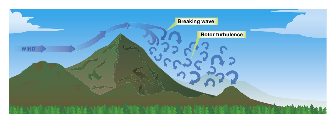
Mountains are among the most dramatic weather-makers on Earth, and understanding how they interact with moving air is essential knowledge for any pilot flying near high terrain. When wind strikes a ridge or mountain range, the air cannot simply pass through — it must go over, setting in motion a chain of atmospheric events that range from gentle lifting to violent, potentially uncontrollable turbulence. The two related phenomena at the heart of this topic are orographic lift — the forced ascent of air over terrain — and mountain wave turbulence, the organized (yet dangerous) oscillation of the atmosphere that can extend hundreds of miles downwind of a mountain range.
Because these hazards are often invisible, occur in clear air, and can exceed the structural limits of light aircraft, the FAA treats mountain wave as a serious safety topic. Pilots planning flights over or near mountainous terrain must understand the mechanics well enough to recognize the signs, anticipate the hazards, and make sound go/no-go decisions.
How Orographic Lift Works
The word orographic simply means "relating to mountains." Orographic lift begins the moment a moving air mass encounters a terrain barrier. The windward side of the mountain (the side facing into the wind) forces air upward along the slope. As the air rises, it cools at approximately the dry adiabatic lapse rate (about 3°C, or roughly 5.4°F, per 1,000 feet) if unsaturated, and at the slower moist adiabatic rate if condensation is occurring. This cooling can produce clouds and precipitation on the windward side even when the overall weather pattern seems benign.
Once air crests the ridge, it descends on the leeward side (downwind side), warming as it compresses. This descending, warming air is typically drier than when it started — a phenomenon that produces the famous Foehn effect (or "Chinook" winds in the Rockies), where air arriving on the lee side is significantly warmer and drier than the original air mass. While Foehn winds can create pleasant weather on the lee side, the associated dynamics also set the stage for mountain wave formation.
Mountain Wave Formation
A mountain wave (also called a standing wave or lee wave) forms when stable air flows over a mountain barrier with sufficient wind speed and the right vertical wind profile. The displaced air, rather than simply flowing smoothly over the obstacle, oscillates up and down in a series of wave crests that can extend hundreds of miles downwind at high altitudes, sometimes reaching the stratosphere. These waves are "standing" because they remain fixed in position relative to the terrain even as individual air parcels move through them.
Three conditions favor mountain wave development, as outlined in the Aviation Weather Handbook:
- Wind speed: Winds of approximately 20 knots or more at ridge level are generally regarded as favorable for mountain wave formation, with stronger winds producing more pronounced waves. The wind should be roughly perpendicular to the ridge (within about 30 degrees).
- Atmospheric stability: A stable layer at or above ridge height is needed. Stability gives the displaced air parcel the "spring" to oscillate rather than mix chaotically.
- Wind direction consistency: Wind direction should remain relatively constant with altitude (no rapid veering or backing), allowing the wave pattern to organize coherently.
The Three Zones of Hazard
Mountain wave systems produce distinct hazardous zones that pilots must understand individually.
1. Cap Cloud and Windward Updrafts
On the windward slope, strong updrafts can exceed the climb performance of light aircraft. A cap cloud or banner cloud may form directly over the peak, wrapping around the summit and visually telegraphing heavy lifting. Airspeed can increase dramatically in updraft regions, and control can become difficult.
2. The Leeward Downdraft Zone
Immediately on the leeward side of the ridge, powerful downdrafts can develop, with documented cases reaching several thousand feet per minute in severe mountain wave events. A light aircraft descending at full climb power may still lose altitude rapidly. Pilots flying low over the lees of mountains in strong wind conditions face the very real risk of being pushed into terrain. A widely-taught mountain flying technique recommends crossing mountain ridges with extra altitude in reserve and approaching the ridge at an angle (commonly cited as around 45 degrees) so that a quick turn away from terrain is possible if a severe downdraft is encountered.
3. Rotor Turbulence
Beneath each wave crest on the leeward side, a violently turbulent horizontal vortex called a rotor forms. Rotors are often the most dangerous element of a mountain wave system. The air within a rotor circulates with extreme irregularity, and turbulence in the rotor zone is frequently rated severe to extreme. Rotors typically occur at or below ridge elevation, but they can extend surprisingly high in intense wave systems. A classic visual cue for rotor activity is the rotor cloud (also called a "roll cloud"), a ragged, churning cloud mass that appears to spin beneath the smooth lenticular clouds above.
4. Lenticular Clouds
The most visually striking marker of a mountain wave is the lenticular cloud (technically an altocumulus standing lenticularis, or ACSL). These lens- or saucer-shaped clouds form at the crest of each wave where rising air cools to its dew point, and they dissipate on the descending side. Because air continuously flows through the cloud while the cloud itself stays fixed, lenticulars appear stationary even in high winds — a key identifying feature. Their presence is a reliable sign of mountain wave activity and potential severe turbulence in the vicinity.
Why It Matters: Safety Implications
Mountain wave accidents have destroyed aircraft and killed experienced pilots. The forces involved can exceed the design load limits of certificated aircraft in just seconds. In severe wave events, turbulence has caused structural failures, upset attitudes that exceeded instrument flying capability, and rapid altitude losses that left no margin over terrain. Even moderate mountain wave turbulence can injure unbelted passengers and cause spatial disorientation.
Beyond structural concerns, pilots must be alert to the rapid airspeed fluctuations that waves produce. Flying through alternating updrafts and downdrafts causes airspeed to surge and drop repeatedly, complicating any attempt to maintain altitude or a stable approach. In IMC conditions, the combination of turbulence and altitude fluctuation makes instrument flying particularly demanding.
Key Numbers and Rules
- ~20 knots: Approximate minimum wind speed at ridge level generally regarded as favorable for mountain wave activity.
- Several thousand fpm: Downdraft strength documented in severe mountain wave events; extreme cases can be even stronger.
- ~45-degree crossing angle: A commonly taught mountain-flying technique for approaching a ridge, allowing a quick escape turn away from terrain.
- Extra altitude reserve: Plan to cross ridges with significantly more altitude than the minimum required — enough margin that a strong downdraft cannot drive the aircraft into terrain before a divert is possible.
- Hundreds of miles downwind: Mountain waves can extend far beyond the mountains themselves, meaning wave turbulence is possible in apparently benign, flat terrain downwind of a major range.
- Lenticular clouds (ACSL): A definitive visual indicator of wave activity; treat any lenticular sighting as a warning of potential severe turbulence nearby.
- Rotor zone: Located below wave crests on the leeward side, typically at or below ridge elevation; associated with the most intense turbulence in the wave system.
Memory Aid
A practical memory aid for the leeward hazard zones from top to bottom is "Lens, Wave, Rotor" — matching what you see visually to the altitude band of hazard:
- Lens (lenticular cloud) — upper-level wave crests, severe turbulence possible in and near the cloud.
- Wave — the organized oscillation itself, with strong updrafts and downdrafts throughout the mid-levels.
- Rotor — the lowest zone, below and beneath the lenticular, with the most chaotic and extreme turbulence.
Remember: if you can see the lens, the rotor is somewhere below it — and you do not want to fly through either without careful planning and adequate altitude.
Common Test Traps
- Lenticular clouds appear stationary but are not calm. A common misconception — and a favorite trap — is that the apparent stillness of a lenticular cloud means the air is smooth. In reality, air is rushing through the cloud at high speed, and severe turbulence is likely both inside and near the cloud.
- Mountain waves extend far downwind. Students often assume mountain wave hazards are limited to the immediate area above the peaks. In fact, waves can propagate hundreds of miles downwind at altitude, creating severe turbulence over flat terrain with no terrain warning cues.
- Updrafts on the windward side are also dangerous. The exam sometimes focuses only on leeward downdrafts. Remember that windward updrafts can also cause loss of control, structural stress from rapid airspeed increase, and inadvertent entry into clouds.
- Rotor turbulence is the most severe, not the wave itself. The smooth-looking lenticular sits above the rotor, but the rotor zone below is where the extreme turbulence lives. Do not assume that being below the clouds means being below the hazard.
- Wind perpendicular to the ridge is the critical factor, not just wind speed. Strong winds parallel to a ridge produce much less wave activity. The FAA specifies that wind should be within approximately 30 degrees of perpendicular to the ridge for significant wave development.