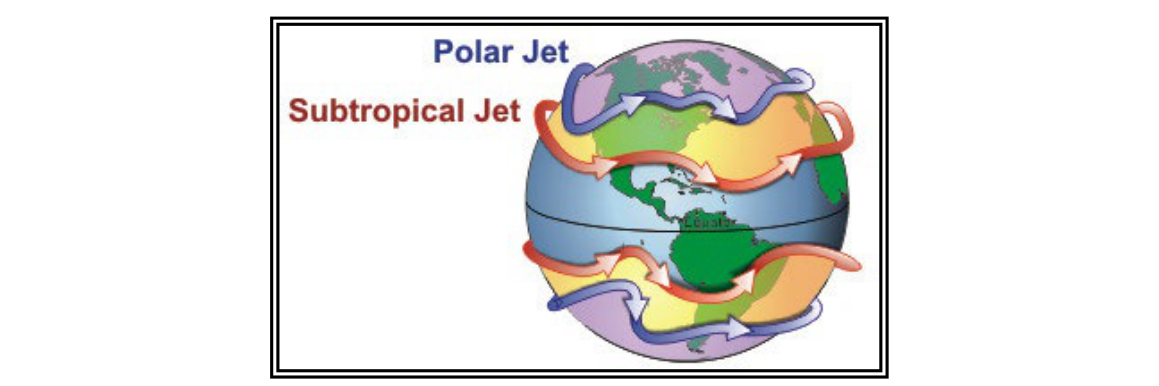
Few atmospheric phenomena affect aviation as broadly as the jet stream. These concentrated corridors of high-speed wind snake around the globe at altitudes that coincide almost exactly with the cruise levels of commercial and high-performance general aviation aircraft. To understand why jet streams exist, where they are found, and why they change with the seasons, a pilot must first understand the global circulation of the atmosphere and the critical role that temperature gradients play in producing strong upper-level winds.
The FAA Aviation Weather Handbook (FAA-H-8083-28B), Chapter 9, provides the authoritative framework for this topic. What follows expands on that framework so that pilots can apply the concepts practically — whether interpreting a prognostic chart, filing an IFR flight plan across the country, or anticipating turbulence in the flight levels.
Global Circulation: The Foundation of Jet Stream Formation
To appreciate how jet streams form, start with the simplest possible model of Earth's atmosphere. If our planet did not rotate, had no axial tilt, and was covered entirely by land, solar heating at the Equator would create one enormous convection loop: hot equatorial air would rise, travel toward the poles, cool, sink, and return to the Equator along the surface. The result would be a single, planet-wide circulation cell with high pressure at each pole and a continuous belt of low pressure around the Equator.
Reality is far more complex. Because the Earth rotates, its axis is tilted approximately 23.5 degrees relative to its orbital plane, and because there is significantly more land mass in the Northern Hemisphere than the Southern, the single-cell model breaks down entirely. Instead, three distinct circulation cells develop in each hemisphere:
- Hadley Cell — Operates between the Equator and roughly 30° N/S latitude. Warm equatorial air rises, moves poleward in the upper atmosphere, cools, and sinks near 30° latitude. Surface winds in the Hadley Cell blow from the northeast in the Northern Hemisphere (the trade winds).
- Ferrel Cell — Occupies the mid-latitudes, roughly 30°–60° N/S. Air flows poleward and eastward near the surface, and equatorward and westward aloft. This is an indirect circulation cell, driven by the Hadley and Polar cells that bracket it.
- Polar Cell — Air rises at approximately 60° latitude, moves toward the poles in the upper atmosphere, sinks at the poles forming polar high-pressure centers, and then diverges outward at the surface as the polar easterlies.
The boundaries between these cells create alternating bands of surface high and low pressure. High-pressure belts sit at roughly 30° N/S (the subtropical highs, responsible for the world's great deserts) and at the poles themselves. Low-pressure bands appear at the Equator and again at 50°–60° N/S latitude. That second low-pressure band — where the Ferrel Cell meets the Polar Cell — is particularly important: it marks the location of the polar front, and it is here that the most significant jet stream in the Northern Hemisphere is found.
Why Jet Stream Winds Blow West to East: Conservation of Momentum
Understanding the west-to-east direction of jet stream winds requires thinking about the Earth's rotation and the concept of conservation of angular momentum. Every point on Earth's surface moves eastward as the planet rotates, but not at the same speed. The Equator moves at roughly 1,000 miles per hour (mph) relative to Earth's axis. A point at 45° latitude moves considerably slower, and the poles barely move at all.
When air near the Equator begins moving poleward as part of the Hadley Cell circulation, it carries with it the eastward momentum it had at its point of origin. As that air travels toward higher latitudes, the Earth's surface beneath it is rotating more slowly. The air, however, maintains its original eastward speed. The result is that the air progressively outpaces the surface below it — it moves faster and faster in an eastward direction relative to the ground the farther it travels from the Equator. This deflection caused by Earth's rotation is called the Coriolis effect, and it is the fundamental reason that upper-level winds become westerly (blowing from west to east) rather than continuing to flow simply from Equator to pole.
Temperature Gradients and the Polar Front: Where Jet Streams Live
The locations around 30° N/S and 50°–60° N/S are not only cell boundaries — they are also the zones where the horizontal temperature difference between adjacent air masses is greatest. This is critical because wind speed in the upper atmosphere is directly related to the magnitude of the temperature gradient at the surface and lower levels below it. The greater the temperature contrast across a boundary, the stronger the pressure gradient aloft, and the faster the resulting wind.
At the 50°–60° N/S boundary, cold polar air meets relatively warmer mid-latitude air, creating what meteorologists call the polar front. The intense temperature contrast across the polar front generates the polar jet stream, the most energetic jet stream in the Northern Hemisphere. This jet stream typically flows between approximately Flight Level (FL) 250 and FL 350 (roughly 25,000–35,000 feet MSL).
At the boundary near 30° N/S, where the descending air of the Hadley Cell meets the rising edge of the Ferrel Cell, a second, generally weaker jet stream forms — the subtropical jet stream. The subtropical jet tends to travel at higher altitudes, often near FL 390–FL 450, and is most prominent in winter when the Hadley Cell expands equatorward.
Both jet streams vary in height from approximately FL 200 to FL 450 and can reach speeds exceeding 275 mph (239 knots). While a TV meteorologist may draw a jet stream as a single line on a map, the actual phenomenon is more like a river than a line. Wind speeds increase gradually toward a central core of highest velocity, then taper off toward the edges. A pilot transitioning across the jet stream may encounter significant wind shear at the boundaries of that core.
Seasonal Variation and the Sun's Influence
Jet streams are not static features. Because they follow the boundaries between hot and cold air masses, they shift with the seasons as solar heating patterns change. In winter, the contrast between polar and mid-latitude air is at its maximum — cold air dominates a large area, the temperature gradient across the polar front is sharp, and the jet stream is at its fastest and most southerly position over the continental United States. In summer, the polar regions warm somewhat, the temperature gradient weakens, and the polar jet stream retreats northward into Canada. As autumn returns and solar elevation decreases, the jet stream migrates southward again, transporting colder air into the United States.
The FAA handbook also notes that jet streams follow the Sun in a broader sense: as spring progresses and solar elevation increases each day, the jet shifts poleward; as the Sun's elevation decreases in autumn, the jet moves equatorward. This seasonal migration has direct implications for flight planning — pilots crossing the country in January may face a 150-knot headwind component at FL 350, while the same route in July may have far lighter upper-level winds.
Meandering, Splitting, and Disappearing
Jet streams rarely follow a clean, predictable path around the globe. They meander in large north-south waves (sometimes called Rossby waves), dip southward in deep troughs, bulge northward in ridges, occasionally split into two branches, form eddies, and may even break down entirely in one location only to reform elsewhere. These meanders are driven by the complex interaction of surface high- and low-pressure systems, warm and cold air mass boundaries, and the topography of major mountain ranges. Understanding this variability is essential for pilots who rely on forecast jet stream positions for flight planning purposes.
Key Numbers and Rules
- Polar jet location: approximately 50°–60° N/S latitude, strongest in winter; in summer it retreats to Canada and beyond.
- Subtropical jet location: approximately 30° N latitude (Northern Hemisphere winter, most prominent).
- Altitude range: jet streams vary from approximately FL 200 to FL 450 (roughly 20,000–45,000 feet MSL).
- Maximum recorded speeds: greater than 275 mph (239 knots / 442 km/h).
- Direction of flow: always west to east (westerly) due to conservation of angular momentum and the Coriolis effect.
- Seasonal rule: temperature gradients are most pronounced in winter → jet streams are strongest in winter for both hemispheres.
- Pressure band high: approximately 30° N/S and at the poles.
- Pressure band low: at the Equator and 50°–60° N/S latitude.
Why It Matters for Pilots
Jet streams have direct operational consequences. Westbound flights at cruise altitude that inadvertently fly through the jet stream core can face headwinds well over 100 knots, dramatically increasing fuel burn and flight time. Conversely, eastbound flights can exploit tailwinds of 100–150 knots or more, reducing fuel consumption and en route time significantly. Wind shear at the edges of the jet stream core — both horizontal and vertical — can produce severe clear-air turbulence (CAT) without any visible indication to the crew. The FAA handbook's analogy of a river is apt: the strongest current is in the center, and the greatest turbulence often lurks at the banks where fast- and slow-moving air meet.
For IFR flight planning, forecasters issue Significant Meteorological Information (SIGMETs) for severe CAT associated with jet streams, and upper-air charts (especially the 250 mb and 300 mb constant-pressure charts) depict jet stream cores with isotachs. Pilots and dispatchers use these products to select the most favorable altitude and routing.
Common Test Traps
- Direction confusion: Jet streams blow from west to east (they are westerly winds). A common distractor reverses this. The Coriolis effect deflects poleward-moving air to the right in the Northern Hemisphere, producing westerly upper-level flow.
- Strongest in summer vs. winter: Jet streams are strongest in winter, not summer, because temperature gradients across the polar front are greatest when the contrast between polar cold and mid-latitude warmth is at its peak.
- Single jet vs. two jets: The polar jet and the subtropical jet are distinct features at different latitudes and altitudes. Exam questions may describe characteristics of one and ask you to identify which jet stream is being described.
- Jet stream as a line: A jet stream depicted as a single line on a chart marks the core of highest wind speed, but the actual wind field is broad, more like a river than a line, with wind shear and turbulence potential across its width.
- Altitude range: Jet streams span FL 200 to FL 450 — not a fixed single altitude. Confusing the typical cruise-level appearance of the polar jet (around FL 250–350) with a hard rule can lead to errors on wind and weather questions.