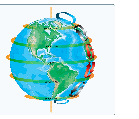
If you have ever wondered why deserts cluster around 30° latitude, why commercial flights from New York to London take less time than the return trip, or why the Pacific Northwest is perpetually damp, the answer lies in the same place: the three-cell circulation model of Earth's atmosphere. The FAA Aviation Weather Handbook explains that because Earth rotates, its axis is tilted, and land masses are unevenly distributed between hemispheres, a single pole-to-equator convection loop is impossible. Instead, the atmosphere organizes itself into three distinct circulation cells in each hemisphere — the Hadley cell, the Ferrel cell, and the Polar cell — each with characteristic surface winds, pressure belts, and weather tendencies that directly affect every flight you plan.
Understanding these cells is not merely academic. The pressure belts they create, the wind patterns they drive, and the jet streams they spawn are all encoded into weather charts, winds-aloft forecasts, and the flight planning decisions you make before every departure. Examiners test this material precisely because it underpins so much of practical meteorology.
The Simplified Starting Point: A Non-Rotating Earth
To appreciate why the three-cell model exists, first consider what the atmosphere would do without Earth's rotation. Solar heating is most intense at the equator, so equatorial air warms, becomes less dense, and rises into the upper atmosphere. That upper-level air flows poleward, gradually cools and sinks at the poles, then returns equatorward along the surface as a cool low-level flow. The result would be a single, planet-spanning convection loop in each hemisphere, with one large high-pressure center at each pole and a continuous belt of low pressure around the equator. Simple, elegant — and not what actually happens.
Earth's rotation, axial tilt, and the unequal distribution of land and ocean break that single loop into three smaller, stacked cells. The Coriolis effect deflects moving air to the right in the Northern Hemisphere and to the left in the Southern Hemisphere, preventing air from traveling in a straight north-south path and instead curving it into the characteristic wind belts pilots know from weather charts.
The Three Cells Explained
Hadley Cell (0°–30° latitude)
The Hadley cell is the most powerful of the three and is driven directly by solar heating at the equator. Intense surface heating causes air to rise, forming the Intertropical Convergence Zone (ITCZ) — a persistent belt of low pressure, deep convection, and frequent thunderstorm activity that encircles the globe near the equator. The rising air diverges at altitude and flows poleward in the upper atmosphere. As this upper-level air travels away from the equator, the Coriolis effect curves it increasingly eastward. By the time it reaches roughly 30° latitude, it has lost enough energy to sink back toward the surface.
This sinking, diverging air at 30° N and 30° S creates a subtropical high-pressure belt. Sinking air warms by compression (adiabatic warming), suppresses cloud formation, and produces the dry, stable conditions associated with the world's great deserts — the Sahara, the Arabian Desert, the Sonoran Desert, and the Australian Outback all sit near this latitude band. At the surface, air flowing equatorward out of the subtropical highs is deflected by Coriolis to produce the trade winds — northeasterly in the Northern Hemisphere and southeasterly in the Southern Hemisphere. These were the reliable winds that powered centuries of trans-oceanic sailing.
Ferrel Cell (30°–60° latitude)
The Ferrel cell occupies the middle latitudes and is often described as an indirect or thermally indirect cell, meaning it is largely driven by the circulations on either side of it rather than by its own internal temperature contrasts. Near the surface, air flows poleward and eastward, producing the prevailing westerlies — the dominant surface wind direction across the continental United States, Europe, and most mid-latitude regions. At higher levels, the flow reverses, moving equatorward and westward.
The FAA handbook notes that the Ferrel cell and its boundaries produce a low-pressure belt at approximately 50°–60° N/S latitude. This region, especially along the west coasts of continents, experiences frequent storm systems and higher precipitation as cyclones develop and travel within the westerly flow. Think of the persistent storminess of the Pacific Northwest, Iceland, and southern Chile — all products of this latitude band. The contrast between the warm subtropical air from the south and cold polar air from the north is greatest here, making it the birthplace of mid-latitude cyclones and frontal weather.
Polar Cell (60°–90° latitude)
The Polar cell is comparatively simple. Air rises near 60° latitude (fed partly by the poleward-flowing surface air of the Ferrel cell), diverges aloft, travels toward the poles, and sinks over the polar caps. This sinking produces persistent polar high-pressure centers — the Arctic and Antarctic highs. At the surface, air flows outward (equatorward) from these highs and is deflected westward by the Coriolis effect, creating the polar easterlies. Where the cold polar easterlies collide with the warmer mid-latitude westerlies near 60° latitude, the polar front forms — a boundary of sharp temperature contrast that is meteorologically one of the most significant features on Earth.
Pressure Belts and Their Weather Significance
The three cells create a repeating pattern of pressure belts around the globe. Memorizing the approximate latitudes and expected weather at each belt is essential for both the written exam and practical flying:
- Equator (0°): Persistent low pressure (ITCZ), rising air, frequent thunderstorms, heavy precipitation, calm or variable surface winds historically called the doldrums.
- ~30° N/S (Subtropical Highs): Sinking air, suppressed clouds, hot and dry conditions — home to the world's major deserts. Surface winds diverge equatorward as trade winds and poleward as the westerlies.
- ~50°–60° N/S (Subpolar Lows): Rising air, cyclone formation, frontal activity, heavy precipitation. West coasts of continents at these latitudes are among the cloudiest and wettest on Earth.
- Poles (~90° N/S): Sinking air, polar highs, cold and dry conditions, surface easterlies diverging outward.
The pattern is clear on any world atlas: the world's major deserts cluster near 30° latitude under the subtropical highs, while the 50°–60° zone is markedly stormier and wetter, particularly along west coasts.
Jet Streams: The Aviator's Direct Connection to Global Circulation
Where circulation cells meet, the temperature contrast between air masses is greatest, and it is precisely at these boundaries that the upper-atmosphere winds accelerate into jet streams. The physics is rooted in conservation of momentum: as air moves poleward from the equator, it retains the faster eastward velocity it had at lower latitudes. Since the Earth's surface rotates progressively slower at higher latitudes, this air races eastward relative to the ground below — producing the west-to-east jet stream winds.
Two primary jet streams affect aviation in the Northern Hemisphere:
- Polar Jet Stream: Located near the polar front at roughly 50°–60° N latitude. This is the stronger and more variable of the two, most intense in winter when the temperature contrast across the polar front is greatest. It typically resides between approximately FL 300 and FL 400 and can reach speeds well over 100 knots, with strong cases exceeding 200 knots.
- Subtropical Jet Stream: Located near 30° N, at the poleward edge of the Hadley cell. Generally more consistent in position but typically weaker than the polar jet.
Jet streams are not sharp lines but wide rivers of accelerating air, analogous to a river where the current is strongest at the center and weaker toward the banks. They meander north and south in waves, split, form eddies, and occasionally disappear and reform elsewhere. Seasonally, jet streams follow the sun: in summer, the polar jet retreats northward into Canada; in winter, it plunges southward across the United States, steering cold air masses and storm systems equatorward.
For flight planning, flying with the jet stream (westbound-to-eastbound routing) can provide significant tailwinds and fuel savings. Flying against the jet adds headwind penalties and block time. Turbulence associated with jet stream wind shear — particularly clear-air turbulence (CAT) near the jet core — is a significant operational hazard, especially on the cold-air (poleward) side of the jet where wind speed gradients are steepest.
Why It Matters for Pilots
The three-cell model is not just atmospheric theory. Every significant weather pattern you encounter traces back to it. Frontal systems develop where cells meet. Persistent high pressure over the southeastern United States in summer is a manifestation of the subtropical high. The reliable westerly winds that govern en-route flight across North America and the North Atlantic are the surface expression of the Ferrel cell. The jet streams encoded in your winds-aloft forecast are the upper-level signature of the temperature boundaries between cells. Even the predictability of trade winds that made classic ocean crossings possible reflects the steady equatorward flow on the equatorial side of the Hadley cell.
Key Numbers and Rules
- Equatorial low pressure (ITCZ): ~0° latitude — rising air, heavy convection, doldrums at the surface.
- Subtropical high pressure: ~30° N/S — sinking air, deserts, trade winds equatorward, westerlies poleward.
- Subpolar low pressure: ~50°–60° N/S — rising air, frontal weather, heavy precipitation on west coasts.
- Polar high pressure: ~90° N/S — sinking air, polar easterlies at the surface.
- Polar jet stream: ~50°–60° N latitude, roughly FL 300–FL 400, with strong cases exceeding 200 knots.
- Subtropical jet stream: ~30° N latitude, generally weaker and more consistent than polar jet.
- Jet streams are strongest in winter when temperature contrasts are greatest.
- Jet streams shift northward in summer, southward in winter, following solar elevation.
Common Test Traps
- Confusing wind direction in the Ferrel cell: Surface winds in the Ferrel cell blow generally from the west in the Northern Hemisphere (westerlies), not from the east. The polar easterlies belong to the Polar cell, not the Ferrel cell.
- Mixing up which pressure belt sits where: High pressure is at ~30° and at the poles; low pressure is at the equator and at ~50°–60°. Students often mistakenly place a high at 60°.
- Assuming jet streams always blow due west-to-east: Jet streams meander in waves, dip southward and rise northward, split, and reform. They are not simple west-to-east straight flows.
- Thinking jet streams are strongest in summer: Jet streams are strongest in winter because the temperature contrast between polar and tropical air is greatest during winter months.
- Forgetting the desert-latitude connection: Deserts at 30° N/S are not random — they are a direct consequence of the sinking, drying air in the subtropical high belt produced by the Hadley cell.