Jet streams are among the most influential weather phenomena an IFR or high-altitude pilot will ever encounter. These fast, narrow corridors of upper-level wind can push an airliner along at ground speeds exceeding 600 knots or create severe turbulence that injures passengers. Yet their existence, location, and seasonal behavior all trace back to a few elegant principles of global atmospheric circulation. Understanding those principles — as laid out in the FAA Aviation Weather Handbook (FAA-H-8083-28B), Chapter 9 — gives pilots a mental model they can apply every time they pull up a prog chart or winds-aloft forecast.
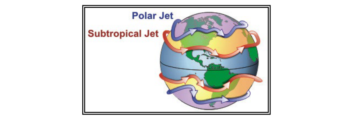
The Earth hosts two primary jet streams in each hemisphere: the polar jet stream and the subtropical jet stream. Both blow predominantly from west to east, both migrate with the seasons, and both mark boundaries between large air masses with sharply different temperatures. Knowing where each one sits, why it forms, and how it moves is essential knowledge for written-test success and practical flight planning.
Why Earth Has Jet Streams at All
To understand jet streams, start with what global circulation would look like on a non-rotating, non-tilted, waterless planet. Heat from the Sun would warm the equatorial surface most intensely, causing air to rise there and flow toward both poles at altitude, cool, sink over the poles, and return to the equator along the surface — one giant convection loop per hemisphere. Simple and tidy, but nothing like reality.
Earth's rotation, axial tilt, and unequal land–sea distribution break that single loop into three circulation cells per hemisphere:
- Hadley cell — Spans roughly 0° to 30° latitude. Surface air converges near the equator, rises due to intense solar heating, and flows poleward aloft before sinking near 30° N/S. This cell drives tropical and subtropical climates and produces the trade winds near the surface.
- Ferrel cell — Spans roughly 30° to 60° latitude. Air flows poleward and eastward at the surface and returns equatorward and westward at altitude. This is a thermally indirect, mechanically driven cell sandwiched between the other two.
- Polar cell — Spans roughly 60° to 90° latitude. Cold, dense air sinks over the poles, spreads equatorward at the surface as polar easterlies, rises near 60° latitude, and flows back poleward aloft.
Between adjacent cells, alternating bands of surface high and low pressure develop. High-pressure belts sit near 30° N/S (the subtropical highs, responsible for the world's major deserts) and at each pole. Low-pressure bands lie along the equator and near 50°–60° N/S, where mid-latitude storm tracks concentrate. This pattern explains why the American Southwest and the Sahara are arid while the Pacific Northwest and northern Europe are persistently stormy.
Why the Winds Blow West to East
The key to jet-stream direction is conservation of angular momentum combined with the Coriolis effect. The surface of the Earth rotates fastest at the equator — a point on the equator moves at roughly 1,040 mph relative to Earth's axis, while a point at 45° latitude moves considerably slower, and a point at the pole barely moves at all.
When equatorial air begins moving poleward in the upper atmosphere, it carries its large eastward momentum with it. As it drifts toward latitudes where Earth's surface is rotating more slowly beneath it, that air appears — from the ground — to be accelerating toward the east. The farther the air travels from the equator, the greater the apparent eastward speed surplus. The result: a powerful west-to-east wind that intensifies with latitude, concentrated wherever temperature contrasts between adjacent air masses are greatest.
Those strongest temperature contrasts occur at the boundaries between the three circulation cells: near 30° N/S and near 50°–60° N/S. These are precisely the latitudes where jet streams are found.
The Two Jet Streams: Location and Character
Polar Jet Stream
The polar jet forms near 50°–60° N/S latitude at the boundary between the frigid polar cell and the warmer Ferrel cell air. It is typically the stronger of the two jets and is most relevant to flights across the contiguous United States, the North Atlantic, and the North Pacific. Its altitude ranges roughly from Flight Level (FL) 200 to FL 450, with core winds that can exceed 275 mph (239 kt). Because the polar jet marks the polar front — the sharpest temperature boundary in the mid-latitudes — it is intimately tied to the formation and movement of extratropical cyclones. Fronts, low-pressure systems, and the worst winter weather tend to trail beneath and around the polar jet's troughs.
Subtropical Jet Stream
The subtropical jet forms near 30° N/S latitude at the poleward edge of the Hadley cell where subsiding air and the temperature gradient aloft combine to create strong upper-level westerlies. The subtropical jet tends to sit somewhat higher — often near FL 390–450 — and is generally less turbulent than the polar jet. It is a significant factor for transoceanic flights and plays a role in steering winter storm systems into the southern United States.
Structure: Not a Line, but a River
Meteorologists and TV forecasters often depict a jet stream as a single line on a map, but the reality is more nuanced. A jet stream is a region of winds that increase toward a central core of maximum speed. Think of a river: the current is fastest at the center and diminishes toward the banks. Jet streams are, quite literally, rivers of air. Wind speeds accelerate as you approach the core and taper off on either side. Pilots crossing laterally through a jet can experience a significant and rapid change in headwind or tailwind component, as well as turbulence in the shear zones flanking the core.
Jet streams also meander dramatically. Rather than circling the globe in neat parallels of latitude, they dip equatorward in troughs and bulge poleward in ridges, carving sinusoidal wave patterns around the hemisphere. They can split into branches, spin off closed eddies, or even temporarily disappear and re-emerge elsewhere. The precise path at any moment depends on the interaction of surface high- and low-pressure systems, temperature contrasts, and topography.
Seasonal Migration
Jet streams follow the Sun. As solar elevation increases through spring, the thermal equator shifts northward, the Hadley cell boundary and polar front migrate poleward, and the jet streams follow. By summer, the polar jet commonly retreats into Canada, and the contiguous United States experiences weaker, more northerly jet-stream influence. The subtropical jet may weaken considerably or shift well to the north.
As autumn arrives and solar elevation decreases, the polar front plunges southward. The polar jet descends back into the continental United States, strengthening rapidly as temperature contrasts between Arctic and tropical air masses intensify. This southward migration is literally what delivers cold-air outbreaks and active storm tracks to the lower 48 states each autumn and winter. By mid-winter, the polar jet can sit as far south as the Gulf Coast during particularly amplified pattern configurations.
The bottom line for pilots: winter jet streams are stronger and more southerly; summer jet streams are weaker and more northerly. Planning a transcontinental flight in January means contending with powerful headwinds (or capitalizing on enormous tailwinds) in a way that a June flight may not require.
Operational Significance for Pilots
Jet streams affect flight in several important ways:
- Winds aloft and fuel planning — A 150-kt jet core on the nose can add hours to a transatlantic flight. Routing to stay on the favorable side of the jet core (or inside it for tailwinds) is standard airline practice.
- Clear Air Turbulence (CAT) — The horizontal and vertical wind shear flanking the jet-stream core is a primary source of CAT, which can be severe and completely invisible. CAT risk is highest on the equatorward, low-pressure side of a jet where shear is greatest.
- Storm steering and frontal weather — The polar jet steers surface low-pressure systems and fronts. Identifying the jet on a prog chart lets pilots anticipate where frontal weather will track over the next 24–48 hours.
- Tropopause height — Jet streams occur at or just below the tropopause. Beneath a jet-stream trough, the tropopause is lower; beneath a ridge, it is higher. This matters for high-altitude aircraft operating near the tropopause.
Key Numbers and Rules
- Polar jet location: 50°–60° N/S latitude
- Subtropical jet location: ~30° N/S latitude
- Jet stream altitude range: approximately FL 200 to FL 450
- Maximum recorded jet-stream speeds: more than 275 mph (239 kt)
- Jet streams are strongest in winter when temperature contrasts are greatest
- Jet streams migrate northward in spring/summer and southward in autumn/winter in the Northern Hemisphere
- High-pressure bands at 30° N/S and poles; low-pressure bands at equator and 50°–60° N/S
- Three circulation cells: Hadley (0°–30°), Ferrel (30°–60°), Polar (60°–90°)
Common Test Traps
- Confusing the two jet locations — The polar jet is at 50°–60°, not 30°. The subtropical jet is near 30°. Many students swap them.
- Assuming jet streams are strongest in summer — Wrong. Temperature contrasts between air masses are greatest in winter, making jet streams strongest then. Summer jets are weaker.
- Thinking jet streams blow north–south — Jet streams blow predominantly west to east. They meander north and south in waves, but the core flow is always westerly.
- Treating the jet as a single line — The depicted line marks the core of maximum speed. The actual jet is a broad region of increasing then decreasing wind, like a river with its banks. Turbulence occurs in the shear zones, not just at the depicted line.
- Forgetting the link to surface weather — The polar jet is directly tied to mid-latitude cyclone development and frontal movement. A trough in the jet aloft corresponds to active storm tracks and unsettled weather below.