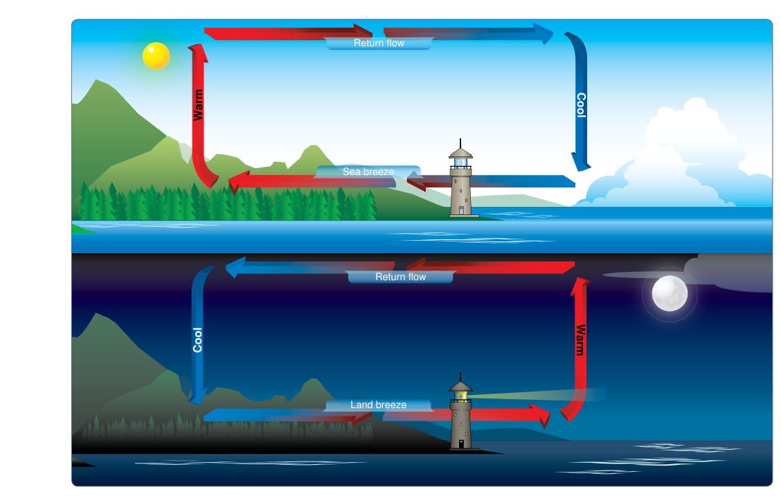
Coastal pilots quickly learn that wind forecasts valid inland can be nearly useless at the shore. Every calm, sunny day sets in motion a predictable thermally driven circulation that reverses direction between day and night. These sea breezes and land breezes belong to a broader family of local wind systems described in the FAA Aviation Weather Handbook as being powered by diurnal heating and cooling of the ground. Because they operate over distances less than 100 miles and last fewer than 12 hours, Coriolis force is negligible — the wind simply follows the low-level pressure gradient force (PGF) from cooler, denser air toward warmer, less dense air. Mastering these cycles sharpens situational awareness for departure times, fuel planning, thunderstorm avoidance, and runway selection at coastal airports.
This article focuses on the sea breeze and land breeze, the most practically significant members of the local-wind family that also includes lake breezes, valley breezes, mountain breezes, and mountain-plains wind circulations — all sharing the same thermodynamic engine.
The Physics Behind Local Coastal Winds
Land and water respond very differently to solar radiation. Several factors drive this differential heating: water is transparent enough that solar energy penetrates and mixes through a much greater depth than it does on land, water loses heat through evaporation, and convective mixing continually redistributes heat within the water body. As a result, land heats up — and cools down — far more rapidly than the ocean or a large lake. This contrast in surface temperature creates the pressure differences that drive coastal wind circulations.
During daylight hours, solar heating warms the land surface quickly. Air in contact with the land becomes warmer and less dense than the air over the adjacent water, which remains relatively cool. Density differences produce a low-level pressure gradient: lower pressure over the warmer land, higher pressure over the cooler water. Air accelerates from sea to land along this gradient. As it moves inland, the air rises over the warm land surface — potentially forming cumulus clouds — and sinks back down over the cooler water, suppressing cloudiness offshore. This daytime circulation is the sea breeze.
After sunset the process reverses. Land radiates its heat away quickly while the ocean retains warmth. By late evening or early morning the land is cooler and denser than the water, establishing higher pressure over land and lower pressure over water. Now the PGF points seaward. Air flows from land to water at the surface, rises over the warmer ocean, and sinks over land. This is the land breeze. Because the temperature contrast between land and sea is typically smaller at night than during peak afternoon heating, the land breeze is generally weaker than the sea breeze and more difficult to detect without careful observation.
The Sea Breeze in Detail
Sea breezes are most pronounced on calm, sunny summer days when synoptic-scale winds are light and the sky is mostly clear. A strong synoptic flow can overwhelm or mask the local thermal circulation entirely; conversely, when the large-scale pressure pattern is nearly flat, the sea breeze becomes the dominant near-surface wind for miles inland.
A typical sea breeze develops a few hours after sunrise, peaks in the early-to-mid afternoon when the land-sea temperature contrast is greatest, and gradually dies as the land cools toward evening. Surface wind speeds vary with the strength of heating, veering in direction as the sea breeze front pushes further inland.
The Sea Breeze Front
The leading edge of the advancing marine air mass is called the sea breeze front. It is a narrow zone of temperature and humidity discontinuity, much like a miniature cold front, that produces a wind shift and enhanced cumulus development along its boundary. Cooler, moister ocean air undercuts the warmer, drier continental air, forcing ascent. If the lifted air is sufficiently moist and the atmosphere conditionally unstable, the sea breeze front can trigger showers and even thunderstorms — despite the fact that the convection is too shallow to produce precipitation in many cases.
Three factors primarily govern the position and inland penetration of the sea breeze front:
- Coastline shape — A narrow peninsula or island is especially prone to intense convection because sea breezes advancing from opposite shores converge near the center, producing concentrated upward motion. Florida's afternoon thunderstorm frequency is a well-known real-world example of this coastline-convergence effect.
- Synoptic wind — An opposing synoptic wind slows the front's inland advance; a following synoptic wind accelerates it and can push it many miles inland.
- Land-sea temperature difference — Cloud cover over land, which reduces insolation, weakens the thermal contrast and limits how far the front penetrates. The diurnal cycle modulates this contrast continuously.
The Land Breeze in Detail
The land breeze is the nocturnal counterpart of the sea breeze. It forms after sunset as the land radiates stored heat rapidly and cools below the sea surface temperature. The resulting surface flow is directed offshore, typically reaching only a few knots on most nights. Rising motion over the warmer water can produce low clouds or fog offshore, while the sinking air over land keeps skies relatively clear near the coast. Pilots departing coastal airports before dawn should expect light offshore winds rather than the sea breeze they experienced the previous afternoon.
Lake Breezes: The Inland Equivalent
Large freshwater bodies generate the same thermal circulation. A lake breeze blows from the lake surface onto adjacent shores during the afternoon, driven by the same PGF mechanism as the sea breeze. The Great Lakes generate well-documented lake breeze circulations, particularly in spring and early summer when lake water temperatures are still cold. Lake depth matters: a shallow lake like Lake Erie warms relatively quickly through the season, reducing the temperature contrast and weakening its lake breeze compared to deep lakes like Lake Superior. Where lake breezes from adjacent bodies converge, enhanced thunderstorm development is possible — a hazard well known to pilots operating in the Great Lakes region.
Why These Winds Matter Operationally
Understanding the daily coastal wind cycle has direct, practical implications for flight planning and airmanship:
- Runway selection and crosswind planning: Wind direction at a coastal airport can shift 180° between morning and afternoon. A runway that was a headwind runway at 0800 local may become a crosswind or even tailwind runway by 1400.
- Turbulence and wind shear near the front: The sea breeze front, despite being a local feature, can produce low-level wind shear significant enough to affect takeoff and landing performance. Enhanced cumulus along the front signals rapid upward motion.
- Thunderstorm avoidance: On moist summer days, the sea breeze front, peninsula convergence, and opposing lake breeze collisions are reliable thunderstorm initiation mechanisms. Pilots should anticipate afternoon convection even on mornings that appear benign.
- VFR cloud clearance and ceiling: Clouds form over land in the rising branch of the sea breeze; sinking air offshore keeps skies clear. This asymmetry can affect VFR route planning along the coast.
- Fog and low ceilings: The land breeze advects cool continental air over slightly warmer coastal water at night, occasionally generating sea fog or low stratus that affects early morning operations.
Key Numbers and Rules
- Local wind circulations span less than 100 miles and last less than 12 hours — too small and short-lived for Coriolis force to significantly deflect the flow.
- Sea breezes are most pronounced on calm, sunny, summer days; a strong synoptic wind flow can overwhelm or mask the local thermal circulation.
- The land breeze is generally weaker than the sea breeze because the land-sea temperature contrast is smaller at night than during peak daytime heating.
- The sea breeze front can penetrate tens of miles inland on a strongly heated day with light opposing synoptic flow.
- Peninsula and island coastlines promote convergence of opposing sea breezes near the center, dramatically enhancing convective potential in the afternoon.
- Shallow lakes (e.g., Lake Erie) warm quickly and generate weaker lake breezes in summer compared to deep lakes (e.g., Lake Superior, Lake Michigan).
Common Test Traps
- Direction confusion: Students mix up which way each breeze blows. Remember: the sea breeze blows from sea to land (daytime); the land breeze blows from land to sea (nighttime). The name tells you the source, not the destination.
- Thinking Coriolis applies: Local wind circulations are too small and short-lived for significant Coriolis deflection. They blow essentially straight from high to low pressure, unlike synoptic-scale winds that spiral around pressure centers.
- Assuming sea breeze fronts always produce precipitation: The FAA handbook notes the convection is often too shallow for precipitation to develop. The front is a potential lifting mechanism — actual showers or thunderstorms require sufficient moisture and instability.
- Overlooking the peninsula effect: Examinees are sometimes caught off guard by questions about why peninsulas and islands experience stronger convection than straight coastlines. The answer is convergence of opposing sea breezes, not simply greater heating.
- Ignoring synoptic-scale masking: Local wind circulations are easiest to identify when synoptic-scale winds are weak. A strong regional flow can completely suppress or distort the sea breeze, making it undetectable in surface observations.