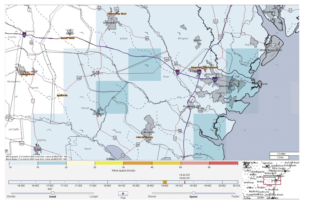
Helicopter Emergency Medical Services (HEMS) flights operate in some of the most demanding weather environments in aviation. Unlike fixed-wing IFR operations that can climb above most low-level hazards, HEMS crews frequently fly at treetop altitude in darkness, marginal visibility, and deteriorating conditions — often with a critically ill patient on board and no option to delay. Standard aviation weather tools were designed primarily with en route, higher-altitude flight in mind. The HEMS Tool, hosted on the FAA Aviation Weather Center (AWC) website, was purpose-built to address this gap by consolidating the weather data that matters most to low-altitude rotor-wing crews into a single, intuitive graphical display.
Understanding how the HEMS Tool is structured, what data it presents, and how to interpret its outputs is essential knowledge for any helicopter pilot, dispatcher, or flight follower — and it is increasingly relevant to the FAA knowledge test as the agency emphasizes weather-decision tools in its updated handbooks.
What the HEMS Tool Is and How It Works
The HEMS Tool is a web-based graphical weather display available through the AWC website. Its defining characteristic is that it is optimized for low-altitude operations — specifically the altitude band from the surface up to 5,000 feet AGL. This makes it fundamentally different from tools like the standard Graphical Forecasts for Aviation (GFA) Tool, which is designed to cover a broader range of flight levels and is more oriented toward en route fixed-wing operations.
The tool achieves its low-altitude focus by interpolating meteorological data to Above Ground Level (AGL) altitudes rather than the pressure altitudes more commonly used in upper-level forecasting products. Temperature, relative humidity, winds, and icing potential are all sliced horizontally at 1,000-foot intervals from the surface up to 5,000 feet AGL. This vertical resolution allows a HEMS pilot planning a 500-foot AGL transit across a valley to examine conditions at the actual altitude they will be flying, not just at a pressure level that may be thousands of feet away from the terrain.
Data Layers and Overlays
One of the HEMS Tool's greatest strengths is the breadth of weather and aeronautical information it brings together in a single view. The following data fields can be overlaid on the display:
- Ceiling and visibility — the two most critical go/no-go parameters for VFR helicopter operations.
- Flight category — color-coded VFR, MVFR, IFR, and LIFR designations derived from ceiling and visibility data, giving an immediate visual picture of conditions across a region.
- Winds — interpolated to AGL altitudes, allowing crews to assess crosswind components and tailwind conditions at their actual operating altitude.
- Relative humidity and temperature — also interpolated to AGL levels; useful for assessing fog potential, density altitude, and the likelihood of icing near the surface.
- Icing potential — critical for any helicopter operating in IMC or near visible moisture; the tool presents icing data in the same AGL-sliced format as the other fields.
- Satellite imagery — provides a broad-scale look at cloud cover and storm systems.
- Radar — both Base Reflectivity and Composite Reflectivity are available, allowing crews to assess precipitation intensity and coverage.
- AIRMETs and SIGMETs — advisories for widespread instrument meteorological conditions, turbulence, icing, and other hazards.
- METARs, TAFs, and PIREPs — point observations, terminal forecasts, and pilot reports are all accessible within the same display, eliminating the need to switch between multiple tools.
From an aeronautical perspective, the HEMS Tool also overlays roads, NAVAIDs, airports, and heliports for the entire United States. This is particularly valuable for HEMS operations because landing zones are often located along roadways or at hospital helipads that are not depicted on standard aviation sectional charts. The ability to see weather data draped over familiar ground reference features helps crews visualize conditions along their actual route, not just in the abstract.
The display supports zooming and panning, and individual layers can be turned on or off independently, allowing users to reduce clutter and focus on the specific data fields most relevant to a given flight.
Time Dimensions: Archive and Forecast
The HEMS Tool is designed around the short time horizon that defines HEMS decision-making. Crews launching on a scene response or interfacility transfer need to know what conditions look like right now and what they will look like in the next few hours — not tomorrow morning.
The tool addresses this need in two ways. First, it provides a rolling 2-hour archive of observed data, updated at 15-minute intervals. This archive allows crews and dispatchers to see how conditions have been evolving — whether a fog bank has been spreading, whether visibility at a particular helipad has been improving or deteriorating, or whether a line of thunderstorms is moving toward a scene. Trend information is often as valuable as a snapshot of current conditions.
Second, the tool provides hourly forecasts extending out to 6 hours. For a typical HEMS mission lasting 30 to 90 minutes, a 6-hour forecast window provides adequate coverage to assess return-leg weather as well as conditions at the intended destination.
Why the HEMS Tool Matters for Safety
HEMS operations have historically experienced a disproportionately high accident rate compared to other helicopter sectors, with inadvertent IMC and continued VFR flight into instrument meteorological conditions identified as leading causal factors. The HEMS Tool directly addresses this hazard by giving crews the granular, AGL-referenced weather picture they need to make informed go/no-go and route decisions before — and during — flight.
The tool's AGL altitude slicing is especially important because the terrain in the United States varies enormously. A forecast product that reports icing potential at 3,000 feet MSL means very different things to a crew flying over the coastal plains of Texas versus a crew threading through mountain valleys in Colorado at 2,500 feet AGL. By anchoring data to AGL levels, the HEMS Tool gives crews information that is directly relatable to their actual operating environment.
Additionally, the integration of METARs, TAFs, and PIREPs alongside graphical data reduces the risk of a crew consulting only one type of weather product and missing a critical hazard reported in another. Comprehensive preflight weather assessment using multiple sources is a foundational principle of FAA risk management guidance, and the HEMS Tool is designed to facilitate exactly that kind of integrated review.
Future of the HEMS Tool
Pilots and dispatchers should be aware that according to the FAA Aviation Weather Handbook (FAA-H-8083-28B), the National Weather Service plans to replace the HEMS Tool with a future upgrade to the GFA Tool. This upgrade will include a Low Altitude mode focused on the 1- to 5-hour timeframe and altitudes up to 5,000 feet AGL — essentially incorporating the core functionality of the HEMS Tool into the broader GFA platform. Until that transition occurs, the HEMS Tool remains a distinct and valuable resource on the AWC website.
Key Numbers and Rules
- Altitude range: Data is sliced at 1,000-ft AGL intervals from the surface up to 5,000 ft AGL.
- Archive depth: 2-hour rolling archive of observed data, updated every 15 minutes.
- Forecast horizon: Hourly forecasts out to 6 hours.
- Coverage area: Entire United States, including CONUS, Alaska, and Hawaii (heliports and airports throughout).
- Overlays available: Ceiling, visibility, flight category, winds, relative humidity, temperature, icing, satellite, radar (Base and Composite Reflectivity), AIRMETs, SIGMETs, METARs, TAFs, and PIREPs.
- Planned successor: GFA Tool Low Altitude mode (replacing the HEMS Tool in a future NWS upgrade).
Common Test Traps
- Confusing HEMS Tool altitude referencing with MSL-based products. The HEMS Tool interpolates data to AGL altitudes — a critical distinction from most upper-level forecast products that use MSL or pressure levels. Exam questions may probe whether you understand why AGL referencing matters for low-altitude operations.
- Mixing up the forecast horizon. The HEMS Tool provides forecasts out to 6 hours, with a 2-hour archive. Do not confuse the 6-hour forecast window with longer-range products like the GFA Tool's extended forecasts or the 24-hour TAF cycle.
- Assuming the HEMS Tool is fixed-wing or high-altitude capable. The tool is specifically designed for operations up to 5,000 ft AGL. It is not a substitute for standard en route briefing tools for higher-altitude fixed-wing flights.
- Overlooking the archive feature. The 2-hour observed data archive with 15-minute update intervals is a key feature that distinguishes the HEMS Tool from a simple current-conditions display. Trend analysis is a testable concept in weather decision-making.
- Believing the HEMS Tool is already replaced. As of the FAA-H-8083-28B publication, the HEMS Tool replacement by the GFA Low Altitude mode was still a planned future upgrade — not yet completed. Examinees should know that the HEMS Tool remains separate from the GFA Tool in its current form.