Mountain flying introduces pilots to a category of weather hazards that flat-land aviators rarely encounter in their careers. Among the most insidious of these are the various fog types that form in and around high terrain — upslope fog, valley fog, and mountain obscuration. Unlike thunderstorms or icing, these phenomena can develop quietly, with no dramatic visual cue, and can trap an aircraft in instrument meteorological conditions (IMC) within seconds of inadvertent entry. The FAA Aviation Weather Handbook (FAA-H-8083-28B), Chapter 16, specifically flags mountain and valley fog and upslope fog as distinct hazards worthy of dedicated study, cross-referencing them to the fog and obscuration chapters for detailed treatment.
Understanding how each fog type forms, why it appears where it does, and how to anticipate its presence is essential for any pilot operating in or near mountainous terrain — whether VFR or IFR. The following sections break down the mechanics, the operational risks, and the key rules that show up on FAA knowledge tests and checkrides.
How Upslope Fog Forms
Upslope fog is a direct product of orographic lifting — the process by which air is forced upward as it flows toward and over rising terrain. When moist air at low levels moves horizontally and encounters a gradual slope, it is forced to ascend. As it rises, it cools at approximately the dry adiabatic lapse rate (roughly 3°C, or about 5.4°F, per 1,000 feet) until it reaches the dewpoint. At that point, moisture condenses and fog or low cloud forms right at the surface of the slope.
The key ingredient for upslope fog is a moist, stable air mass moving toward high ground. The Great Plains states provide a classic example: moist air flowing westward from the Gulf of Mexico encounters the gradual eastward slope of the Rocky Mountain foothills. When winds have an upslope component and relative humidity is high, dense upslope fog can form rapidly across hundreds of miles of terrain, persisting for many hours because the continuous wind flow keeps supplying new moisture to the condensation zone.
Unlike radiation fog, which requires calm winds and clear skies to form overnight, upslope fog can form during the day and in windy conditions as long as the wind is directed upslope. This makes it particularly deceptive — a pilot departing from a plains airport in seemingly good VFR conditions may find the terrain ahead completely obscured just miles away where the ground begins to rise.
How Valley and Mountain Fog Form
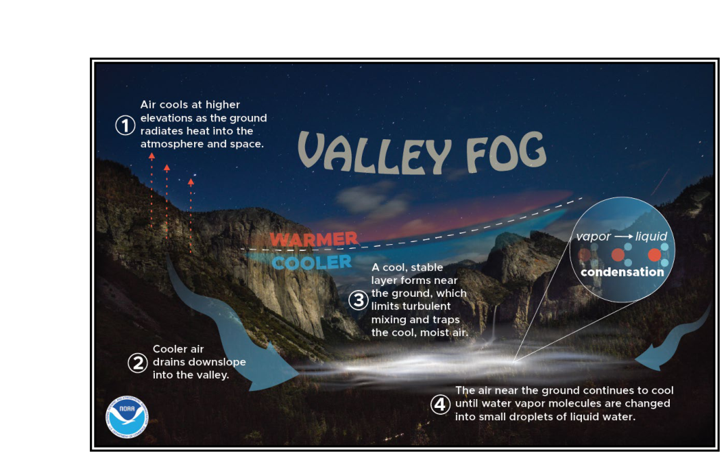
Valley fog forms through a different mechanism that is closely tied to nighttime radiative cooling and the drainage of cold air. During clear nights, terrain surfaces radiate heat rapidly into the sky. The air in contact with these cooling surfaces chills quickly. Because cold air is denser than warm air, it drains downhill and pools in valleys, basins, and other low-lying areas surrounded by higher terrain — a process called cold air pooling.
As the pooled cold air continues to cool, it can reach its dewpoint and saturate, producing valley fog — sometimes called drainage fog in this context. The fog layer fills the valley from the bottom up, and because the surrounding ridgelines are warmer and above the inversion, the fog may be completely invisible to an observer on the ridges. A pilot flying over a mountain range on a clear night may have no idea that the valleys below are completely fogged in to near-zero visibility.
Valley fog is typically deepest just before sunrise, when temperatures are at their minimum. After sunrise, solar heating from above begins to erode the fog from the top down, but the process can be slow, especially in deep, narrow valleys with limited solar exposure. Valleys oriented east-west receive more direct morning sun and tend to clear faster than north-south oriented valleys shaded by ridge walls.
Mountain obscuration is a related but distinct phenomenon addressed in FAA-H-8083-28B, Section 18.2.2. It occurs when clouds, fog, or precipitation completely obscure the upper portions of mountain ridges and peaks. From a distance, the sky may appear partly cloudy or even mostly clear, but the terrain itself is embedded within or below cloud layers. A pilot flying toward apparently open sky may unknowingly be on a collision course with obscured high terrain — a classic controlled flight into terrain (CFIT) scenario.
Why These Fog Types Matter for Mountain Operations
The fundamental danger shared by all three phenomena is that they can reduce flight visibility to zero in very short distances, and they often do so without dramatic forewarning. Upslope fog can form faster than a pilot can reverse course. Valley fog can completely fill a mountain pass or canyon, eliminating the VFR pilot's intended escape route. Mountain obscuration can hide terrain that appears on the sectional chart but is invisible in the actual field of view.
The FAA's mountain weather chapter emphasizes that strong wind flow over irregular terrain produces disturbances — including turbulence and shear zones — that may have no reliable visual indicators. This philosophy extends to fog: the absence of a visible fog bank ahead does not mean the route is clear. Moisture-laden air flowing up a slope may condense only after it has enveloped your aircraft.
For IFR pilots, mountain obscuration creates a unique challenge. Even with an instrument clearance, flying through clouds that contain terrain requires exceptional situational awareness, terrain awareness and warning system (TAWS) monitoring, and strict adherence to published minimum en route altitudes (MEAs) and minimum obstruction clearance altitudes (MOCAs). These altitudes are designed with terrain clearance in mind, but only if the pilot maintains them precisely.
For VFR pilots, the rule is straightforward and non-negotiable: flight into IMC without an instrument rating and a properly equipped aircraft is illegal under 14 CFR Part 91 and has been a recurring factor in fatal mountain accidents. The ability to recognize fog-generating conditions before flight is a core mountain flying survival skill.
Key Numbers and Rules
- Upslope fog trigger: Moist air with winds having an upslope component; any gradual terrain rise can initiate condensation when humidity is near saturation. The slower and more gradual the slope, the more subtle the onset.
- Valley fog timing: Most dense just before sunrise after a clear, calm night; can persist well into mid-morning, especially in deep or north-facing valleys.
- Mountain wind threshold: The FAA's mountain wave and turbulence guidance generally treats ridge-level winds of approximately 25 knots or greater as a rule-of-thumb trigger for significant mountain wave activity and turbulence; strong moisture-laden flow under these conditions can also be associated with fog and low cloud formation on windward slopes.
- VFR cloud clearance in mountainous areas: Under 14 CFR §91.155, VFR minimums require specific distances from clouds depending on airspace class and altitude. In Class E airspace at or below 10,000 feet MSL, pilots must remain 500 feet below, 1,000 feet above, and 2,000 feet horizontally from clouds; above 10,000 feet MSL the minimums increase to 1,000 feet below, 1,000 feet above, and 1 mile horizontally. These minimums assume the pilot can see those clouds — obscured terrain adds a layer of risk they alone do not address.
- MEAs and terrain clearance: Published MEAs guarantee obstacle clearance within the airway protected airspace, but mountain obscuration can exist at and above the MEA; pilots must account for visual identification requirements on approaches in IMC near terrain.
- Stability requirement: Upslope fog requires a stable air mass; an unstable air mass would produce convective lifting and showers or thunderstorms instead of smooth fog layers.
Anticipating These Conditions — Preflight and In-Flight Strategies
The best defense against mountain fog is thorough preflight weather analysis. Pilots should examine the Surface Analysis Chart for high-moisture, stable air masses positioned upwind of mountainous terrain. The Skew-T Log-P diagram or computer-generated soundings can reveal how close the air temperature is to the dewpoint at low levels — a temperature-dewpoint spread of 5°F (about 3°C) or less at the surface indicates high probability of fog or low clouds. Area Forecast Discussions (AFDs) issued by National Weather Service forecast offices frequently include explicit language about upslope fog and valley fog potential.
In flight, visual clues include wisps of cloud forming at terrain level on slopes, reduced visibility in valleys when ridgetops are still clear, and a general milky appearance to the air ahead at low altitudes. Any of these signs warrants an immediate altitude gain or course reversal rather than continued penetration.
Pilots should also be aware of the lenticular cloud connection: as discussed in FAA-H-8083-28B Chapter 16, the presence of lenticular clouds (ACSL or CCSL formations) confirms active mountain wave activity, which in turn signals strong moisture transport. That moisture may be simultaneously producing upslope fog on the windward slopes at lower elevations — an often-overlooked connection between wave clouds aloft and fog hazards at ground level.
Common Test Traps
- Confusing upslope fog with radiation fog: Radiation fog requires calm winds and clear nights; upslope fog can form in moderate winds and during the day as long as flow is directed uphill.
- Assuming valleys are safe beneath overcast: Valley fog can form even when skies are overcast — radiative cooling is not the only mechanism; cold air drainage can occur independently of radiative effects.
- Thinking mountain obscuration is only a VFR problem: IFR pilots are equally at risk if they descend below MEA or attempt to identify terrain visually through obscured conditions.
- Overlooking wind direction in fog forecasting: A steady wind blowing toward rising terrain is the single most important trigger for upslope fog; students often focus on temperature-dewpoint spread and ignore wind direction entirely.
- Assuming clear ridgetops mean clear passes: Valley fog can completely fill a pass or canyon while ridgetops immediately above remain in the clear — the VFR pilot's intended route may be zero-zero while the terrain around it appears perfectly visible.