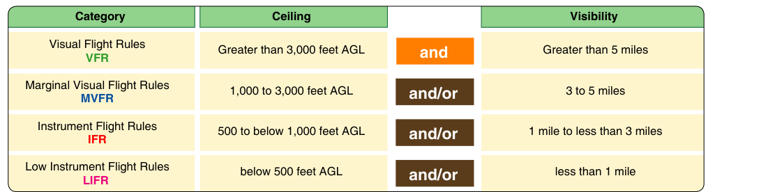
One of the most fundamental responsibilities of a Part 107 remote pilot is ensuring that weather conditions support safe, legal flight before and during every operation. Unlike manned aircraft pilots who rely on cockpit instruments to navigate through reduced visibility, remote pilots operating under Visual Line-of-Sight (VLOS) rules must be able to see and maintain direct unaided visual contact with their unmanned aircraft at all times. That single requirement makes ceiling and visibility the two most operationally critical weather elements a remote pilot will ever evaluate. Understanding what the regulations require, how weather products report these values, and how conditions affect your specific operation is essential for both the FAA Part 107 knowledge test and real-world decision-making.
This article covers the regulatory minimums established under 14 CFR Part 107, explains how ceiling and visibility are defined and reported, and gives you the practical tools to evaluate weather conditions confidently before every flight.
Defining Ceiling and Visibility
Before diving into the regulations, it helps to be precise about what these terms mean in an aviation context, because the FAA uses specific definitions that differ from everyday language.
Visibility refers to the greatest horizontal distance at which prominent objects can be seen and identified with the naked eye. In aviation weather products, surface visibility is reported in statute miles (SM) for U.S. operations. When an aviation routine weather report (METAR) shows "10SM," it means the prevailing visibility is 10 statute miles. Values below 10SM are reported in fractions or whole numbers, such as "1 1/2SM" or "3SM." Visibility can be reduced by fog, haze, smoke, precipitation, dust, or any other obscuring phenomenon.
Ceiling is defined as the height above ground level (AGL) of the lowest layer of clouds or obscuring phenomena that is reported as broken (BKN) or overcast (OVC). A sky condition reported as scattered (SCT) or few (FEW) does not constitute a ceiling. In a METAR, cloud layers are reported as three-digit groups multiplied by 100 to get the height in feet AGL. For example, "OVC018" means an overcast ceiling at 1,800 feet AGL. "BKN025" means a broken ceiling at 2,500 feet AGL — and that would be the ceiling for regulatory purposes.
The Part 107 Regulatory Minimums
Under 14 CFR §107.51, the FAA establishes explicit operating limitations for small unmanned aircraft. Two of these directly address ceiling and visibility:
- Minimum flight visibility: The remote pilot must have at least 3 statute miles of flight visibility from the ground control station.
- Minimum distance from clouds: The small unmanned aircraft must remain at least 500 feet below any clouds and at least 2,000 feet horizontally from any clouds.
It is important to understand what "flight visibility" means in this context. The FAA defines flight visibility as the average forward horizontal distance from the control station at which prominent unlighted objects may be seen and identified by day. This is the visibility as observed by the remote pilot at the ground control station — not necessarily the visibility reported at a distant airport. If the reported visibility at a nearby ASOS is 5SM but you can clearly see that haze or smoke in your operating area is restricting your actual visibility to less than 3SM, you may not legally fly.
The cloud clearance requirements — 500 feet below and 2,000 feet horizontally — exist to keep unmanned aircraft separated from manned aircraft that may be operating in and around clouds under instrument flight rules (IFR) or transitioning from visual to instrument conditions. A manned aircraft descending through a cloud base could break out just 400 feet above the surface and suddenly encounter a drone. These buffers provide a meaningful safety margin.
Why VLOS Makes Weather Especially Critical
The entire Part 107 framework is built on the assumption that the remote pilot can see the aircraft at all times without the aid of magnifying devices (corrective lenses are permitted). This means that reduced visibility does not just create a regulatory problem — it directly undermines the fundamental safety mechanism of VLOS operations.
Consider what happens as visibility drops. At 3SM, a small drone a few hundred feet away may already be difficult to distinguish from birds or background clutter. At 1SM, maintaining visual contact beyond a few hundred feet becomes practically impossible for most operators with most aircraft. Fog, haze, rain, and snow all reduce not just the regulatory visibility number but your actual ability to track the aircraft, assess its attitude, and respond to unexpected situations. Even legally compliant conditions can represent the practical edge of operational safety.
Ceiling matters for similar reasons. If you are operating near the 400-foot AGL altitude ceiling commonly associated with Part 107 (with some site-specific exceptions), a 500-foot AGL cloud base would bring the regulatory cloud floor to just 0 feet — meaning you effectively cannot fly because you cannot maintain 500 feet of separation below the clouds while also staying within 400 feet AGL. Low ceilings compress your operating envelope and, more importantly, increase the risk of encountering IFR traffic at low altitudes.
Obtaining and Interpreting Weather Information
Part 107 does not require remote pilots to use any specific weather product, but it does require you to make a reasonable assessment of conditions before and during flight. The FAA recommends using official aviation weather sources, including:
- METARs (Aviation Routine Weather Reports): Issued hourly or more frequently for special conditions. METARs provide current sky conditions, visibility, temperature, dew point, wind, and altimeter setting. This is your primary source for official ceiling and visibility data.
- TAFs (Terminal Aerodrome Forecasts): 24- to 30-hour forecasts of expected conditions at specific airports. Useful for planning operations hours in advance.
- Aviation Weather Center (aviationweather.gov): The FAA and NOAA jointly operate this free web resource that aggregates METARs, TAFs, winds aloft forecasts, AIRMETs, SIGMETs, and graphical weather products.
- Automated Surface Observing Systems (ASOS) and Automated Weather Observing Systems (AWOS): Ground-based stations that generate continuous weather observations, often accessible by phone or online. These are the source of most METAR data.
When interpreting a METAR, pay close attention to sky condition groups. The reporting format uses contractions: FEW (1-2 oktas coverage), SCT (3-4 oktas), BKN (5-7 oktas), OVC (8 oktas, totally overcast). Only BKN and OVC layers define the ceiling. A METAR reading "FEW015 SCT040 BKN080" means the ceiling is 8,000 feet AGL — the 1,500-foot and 4,000-foot layers are not ceilings and do not restrict operations on their own, though flying near those layers requires maintaining the 500-foot below and 2,000-foot horizontal cloud clearances.
Key Numbers and Rules
- 3 statute miles minimum flight visibility (§107.51)
- 500 feet below clouds minimum vertical separation
- 2,000 feet horizontal from clouds minimum lateral separation
- BKN and OVC layers define a ceiling; FEW and SCT do not
- Cloud heights in METARs are reported in hundreds of feet AGL (multiply the 3-digit group by 100)
- Visibility in METARs is reported in statute miles for U.S. aviation
- Flight visibility is measured from the ground control station, not from a distant weather station
- A waiver from the FAA (via DroneZone) is required to operate below these minimums
Common Test Traps
- Confusing visibility minimums with manned aircraft VFR rules: Manned aircraft operating in Class G airspace below 1,200 feet AGL during the day only need 1SM visibility and clear of clouds. Part 107 requires 3SM and specific cloud clearances regardless of airspace class or time of day — these are drone-specific rules.
- Thinking a scattered layer does not count: A scattered layer (SCT) is not a ceiling, but you still must maintain 500 feet below and 2,000 feet horizontal separation from scattered clouds. The cloud clearance requirements apply to ALL clouds, not just ceilings.
- Using reported airport visibility for a distant site: The reported METAR visibility at an airport 10 miles away may not reflect conditions at your operating site. You must assess the actual visibility from where you are standing. Localized fog, smoke, or haze can create very different conditions than what is reported nearby.
- Misreading METAR cloud heights: The three-digit group in a METAR must be multiplied by 100 to get feet AGL. "BKN030" is 3,000 feet AGL, not 30 feet. Getting this wrong can lead to a serious misreading of how much vertical clearance you actually have.
- Assuming daylight means good visibility: Bright daylight does not guarantee legal or safe visibility. Haze, smoke from wildfires, and humidity can create "blue sky" conditions with surface visibility well below 3SM. Always check an official weather source rather than relying on appearance alone.
Practical Decision-Making Before Each Flight
A disciplined pre-flight weather check for Part 107 operations should include pulling the most recent METAR for the nearest reporting station, checking for any applicable AIRMETs for IFR conditions or mountain obscuration (AIRMET Sierra), reviewing the TAF if planning an operation later in the day, and personally assessing actual visibility from the ground control station before launch. If conditions are marginal — say, visibility reported at 4SM but clearly deteriorating — conservative decision-making means either delaying the operation or canceling it. The regulations set minimums, not recommendations. Operating as close to the minimums as possible on a deteriorating day leaves no margin for error.
Remember that weather conditions can change rapidly. A pre-flight check performed an hour before launch may not reflect conditions at the time of actual flight. Many experienced remote pilots recheck METARs within 30 minutes of launch and monitor conditions throughout the operation, ready to land immediately if visibility drops or clouds descend toward their aircraft.