Most drone pilots fly at or below 400 feet above ground level — an altitude band that sits squarely inside the atmospheric boundary layer, where the wind rarely behaves as smoothly as the upper-level forecasts suggest. Wind shear and turbulence are not just inconveniences for full-scale aircraft; for a small unmanned aircraft system (sUAS) weighing only a few pounds, a sudden gust or an invisible shear layer can push the aircraft far outside its flight envelope in a fraction of a second. Understanding how these phenomena form, where they hide, and how to recognize their warning signs is essential knowledge for every Part 107 remote pilot — both for the FAA knowledge test and for keeping your aircraft safe.
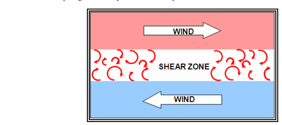
The FAA's Aviation Weather Handbook (FAA-H-8083-28) and the Pilot's Handbook of Aeronautical Knowledge (FAA-H-8083-25) treat wind shear and turbulence as related but distinct hazards. Wind shear refers to a change in wind speed or direction over a short distance — either horizontally or vertically. Turbulence describes the chaotic, irregular motion of air masses that causes rapid, unpredictable fluctuations in airspeed and aircraft attitude. Both can exist without the other, but they often appear together, especially at low altitudes.
How Wind Shear Forms at Low Altitudes
Wind shear develops whenever adjacent air masses move at different velocities or in different directions, and there are several reliable triggers in the low-altitude environment.
Terrain and obstacle-induced shear: When wind flows over and around buildings, tree lines, ridges, or other structures, it separates into areas of fast-moving and slow-moving (or recirculating) air. The boundary between those regions is a shear zone. An sUAS flying from a calm lee-side zone into an exposed area of full wind force can experience an abrupt and powerful change in relative airflow. Rotors — turbulent rolling eddies that form on the downwind side of ridges and large structures — are a particularly severe form of this effect.
Temperature inversions: A temperature inversion occurs when a layer of warm air sits on top of cooler surface air, reversing the normal lapse rate. The warm layer acts like a lid, trapping surface winds below while faster or differently directed winds exist above. The interface between those layers is a pronounced wind-shear zone. Low-level temperature inversions are common at night and in the early morning hours, just when many remote pilots choose to fly for calm, clear conditions — making this a deceptive hazard.
Sea breeze and valley-plain boundaries: Along coastlines and in terrain with mixed land and water or valley-and-plain geography, thermally driven local winds can create sharp horizontal shear boundaries. The leading edge of an advancing sea breeze, for example, behaves much like a micro-scale cold front, with gusty, shifting winds on either side of its boundary.
Frontal passages: Both cold and warm fronts are associated with wind shear at the surface. As a cold front passes, wind direction can shift tens of degrees and speed can change dramatically within minutes. Remote pilots should consult METARs and Terminal Aerodrome Forecasts (TAFs) to track frontal timing, and they should be prepared to terminate a flight when frontal passage is imminent.
How Turbulence Forms at Low Altitudes
Turbulence is classified by the FAA into several types; the two most relevant to low-altitude sUAS operations are mechanical turbulence and convective (thermal) turbulence.
Mechanical turbulence is caused primarily by obstructions to wind flow — friction, surface roughness, and terrain features such as buildings, trees, and ridges — combined with wind speed. It intensifies with wind speed and surface roughness, while atmospheric stability mainly affects how quickly the resulting turbulent eddies dissipate rather than how they are generated. In strong wind conditions over a city or industrial area — with its irregular rooftops, HVAC stacks, and open plazas — the air can be in constant chaotic motion even under clear skies. Mechanical turbulence is often the strongest near the surface and decreases with altitude, though it can extend several hundred feet up in rough terrain or high winds.
Convective turbulence results from solar heating of the ground. As the surface warms, it heats the air in contact with it, creating rising columns of unstable air called thermals. These are separated by areas of sinking air. The boundary between a rising thermal and the surrounding air is a shear interface. On hot summer afternoons over dark pavement or open fields, thermals can be vigorous enough to cause significant control problems for a lightweight drone. Convective turbulence is usually strongest during the afternoon hours when surface heating is at or near its maximum, and diminishes as the surface cools after sunset.
Why These Hazards Matter for sUAS
A full-scale manned aircraft carries substantial inertia and kinetic energy that help it resist sudden atmospheric perturbations. A typical Part 107 sUAS does not. With an all-up weight of a few pounds and relatively low cruise speed — often 20 to 30 knots for a multirotor — a sudden wind-shear encounter that dumps or adds 15 knots of airspeed can represent a very high percentage change in the aircraft's aerodynamic environment. The flight controller software may not be able to compensate quickly enough, especially if the event is accompanied by turbulence.
Practical consequences include: loss of positional accuracy and the potential for the aircraft to drift outside its intended flight area; structural overload in fixed-wing sUAS if gust loads exceed airframe limits; battery drain spikes as motors fight unexpected forces; and, in severe cases, complete loss of control. Any of these can result in a flyaway, a crash, or — most critically — endangerment of people and property on the ground.
Remote pilots have an additional challenge: they cannot feel the aircraft through a control stick the way a manned pilot feels turbulence through the seat and airframe. Visual cues of deteriorating weather must substitute for this tactile feedback, which makes pre-flight weather evaluation even more important than it already is for manned aviation.
Key Numbers and Rules
- sUAS maximum altitude: 400 feet AGL (or within 400 feet of a structure), keeping the aircraft in the turbulent boundary layer for its entire flight.
- Wind limits: Part 107 has no specific regulatory wind speed limit, but the remote pilot in command must not fly when winds or gusts could cause loss of control. Know your aircraft's manufacturer-stated wind limits.
- Mechanical turbulence rule of thumb: Expect turbulence and shear for a distance downwind of an obstacle roughly 10 times the obstacle's height. A 30-foot building can generate rotor-type turbulence up to about 300 feet downwind.
- Convective turbulence peak hours: Typically strongest during the afternoon hours, when surface heating is at or near its maximum, over dark or dry surfaces.
- Temperature inversion clue: Smoke or haze lying in distinct horizontal layers near the surface is a visual indicator of a low-level temperature inversion and potential wind shear above.
- METAR wind data: Surface winds are reported in true degrees and knots. A wind entry such as 18015G28KT means wind from 180° true at 15 knots, gusting to 28 knots — a gust spread of 13 knots that, as a general rule of thumb, suggests the potential for mechanical turbulence at low altitudes (the FAA does not define a specific numeric gust-spread threshold as officially significant).
- PIREPs (Pilot Reports): Low-level turbulence PIREPs from manned aircraft are relevant to sUAS operations, particularly those from traffic pattern altitudes at nearby airports.
Pre-Flight Weather Assessment Strategy
Because remote pilots cannot receive real-time ATC weather advisories or ATIS in the same way manned pilots can during flight, a thorough pre-flight briefing is critical. Use 1800wxbrief.com or an FAA-accepted weather app to obtain a standard weather briefing. Pay attention to: surface wind forecasts and gust factors in Terminal Aerodrome Forecasts (TAFs) and Area Forecasts; SIGMET and AIRMET Sierra (IFR/mountain obscuration) and Tango (turbulence) advisories; and the synoptic situation — strong pressure gradients between weather systems drive persistent surface winds. Check METARs at the nearest reporting station just before flight and compare actual conditions to your forecast. If measured winds are already close to your aircraft's limits, do not fly expecting conditions to improve; they may not.
During the flight, continuously monitor visible cues: are trees swaying? Is smoke blowing horizontally? Do you see dust devils forming? Any of these signals a turbulent, shear-prone environment. The remote pilot in command has the authority — and the responsibility — to terminate any flight when conditions deteriorate.
Common Test Traps
- Assuming calm surface wind means no shear aloft: A temperature inversion can produce strong, differently directed winds just above the calm surface layer. Wind shear does not require gusty surface conditions.
- Ignoring downwind turbulence from obstacles: Many test questions describe a scenario near buildings or trees. Remember that rotor turbulence extends downwind of the obstacle, not just at the obstacle itself.
- Confusing wind shear with turbulence: They are related but distinct. Wind shear is a change in velocity over distance; turbulence is chaotic air motion. Shear often causes turbulence, but turbulence can exist without a pronounced shear layer.
- Forgetting that sUAS have no regulatory minimum wind limit: The FAA expects the remote PIC to make a judgment call. Test questions may present a wind scenario and ask what the pilot should do — the correct answer is to evaluate the conditions against the aircraft's capabilities and the manufacturer's limits.
- Underestimating afternoon convective turbulence on hot, sunny days: Morning calm conditions can give way to vigorous thermal turbulence by early afternoon. A flight plan made at 7 AM may not be safe at 1 PM on the same day.