Every weather phenomenon a pilot encounters — from tropical thunderstorms to Arctic high-pressure systems — traces its energy back to one source: the Sun. But solar energy is not delivered equally across the globe. The angle at which sunlight strikes the Earth's surface varies dramatically with latitude and changes systematically through the year because of Earth's tilted axis. Understanding these geometry-driven differences is essential for grasping why the atmosphere is perpetually in motion and why weather behaves the way it does at different locations and seasons.
The FAA Aviation Weather Handbook (FAA-H-8083-28B), Chapter 7, frames this discussion around heat imbalances — the unequal distribution of solar energy that drives atmospheric circulations, creates temperature gradients, and ultimately produces the weather pilots fly through every day.
The Angle of Solar Radiation and Latitude
Because the Earth is essentially spherical, parallel beams of incoming solar radiation — called insolation (incoming solar radiation) — do not strike every part of the surface at the same angle. At the Equator and lower latitudes, the Sun sits nearly overhead, meaning the solar zenith angle is small. A solar zenith angle is the angular distance between the Sun and a point directly overhead (the zenith); the smaller the angle, the more directly overhead the Sun is.
When sunlight strikes nearly perpendicularly, a given beam of solar energy is concentrated onto a relatively small surface area, delivering intense heating. At higher latitudes, the same beam arrives at a much more oblique angle and is therefore spread over a larger surface area. Think of shining a flashlight straight down on a table versus tilting it at a steep angle — the oblique beam creates a larger, dimmer ellipse. The energy per unit area is dramatically reduced. This geometric effect means the tropics absorb significantly more solar radiation per square meter than the polar regions do.
A second, compounding factor is atmospheric path length. When sunlight arrives at a low angle, it must travel through a much greater thickness of atmosphere before reaching the surface. More atmosphere means more scattering and absorption of solar energy by gases, aerosols, and clouds, further reducing the intensity that reaches the ground at high latitudes.
The Resulting Heat Imbalance
The Earth also emits its own energy back to space as terrestrial (longwave) radiation, and this emission varies with latitude as well — but less dramatically than solar absorption does. Terrestrial emission decreases with increasing latitude primarily because surface temperatures decrease toward the poles, and cooler surfaces radiate less energy.
The net result creates a critical threshold: at approximately 35° latitude in both the Northern and Southern Hemispheres, incoming solar radiation and outgoing terrestrial radiation are in annual balance. Poleward of 35°, cooling exceeds warming — there is a net annual energy deficit. Equatorward of 35°, warming exceeds cooling — there is a net annual energy surplus. If nothing compensated for this imbalance, the tropics would grow steadily hotter and the poles steadily colder. Instead, the excess heat accumulated in the tropics is transported poleward by atmospheric circulations, weather systems, and ocean currents. This poleward heat transport is the fundamental engine driving global weather patterns and the jet streams that pilots rely on for route planning.
Seasons: The Effect of Earth's Axial Tilt
Latitude alone explains the persistent equator-to-pole temperature gradient, but it does not explain why temperatures change through the year at any given location. That is the role of seasons, which are caused entirely by the tilt of Earth's rotational axis.
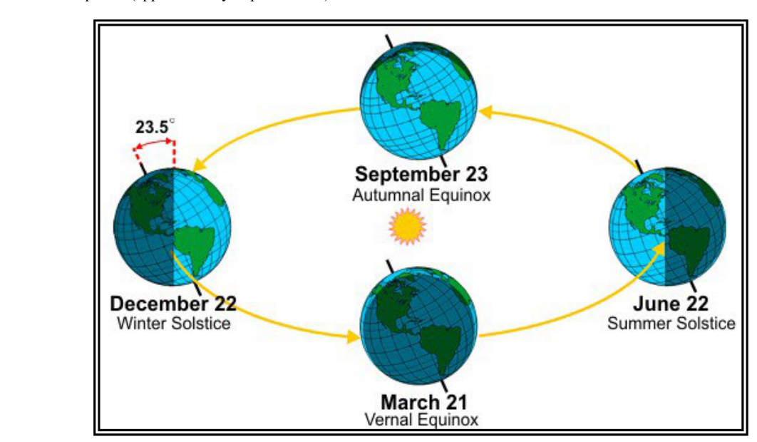
Earth's axis is tilted 23.5° from perpendicular to the plane of its orbit around the Sun, and — critically — this axis points in the same direction in space throughout the entire orbit. As Earth moves around the Sun over the course of a year, this fixed tilt means that first one hemisphere and then the other is angled more directly toward the Sun.
- Summer Solstice (~June 22, Northern Hemisphere): The North Pole is tilted most directly toward the Sun. The solar zenith angle at any Northern Hemisphere location is at its annual minimum (Sun highest in the sky). This is the longest day of the year, with the greatest hours of daylight and the most intense insolation.
- Winter Solstice (~December 22, Northern Hemisphere): The North Pole is tilted most directly away from the Sun. The solar zenith angle is at its annual maximum (Sun lowest in the sky). This is the shortest day of the year, with the fewest hours of daylight and the weakest insolation.
- Vernal Equinox (~March 21) and Autumnal Equinox (~September 23): Earth's axis is neither tilted toward nor away from the Sun. Day and night are each approximately 12 hours long everywhere on Earth.
It is important to note that Earth is actually slightly closer to the Sun during Northern Hemisphere winter (perihelion, around January 3) and slightly farther away during summer (aphelion, around July 4). This proves that distance from the Sun is not what causes seasons — axial tilt is. The Southern Hemisphere experiences its summer while the Northern Hemisphere experiences winter, simply because the hemispheres are tilted oppositely relative to the Sun.
The Seasonal Temperature Lag
One of the most practically important — and commonly misunderstood — aspects of seasons is the temperature lag. The longest day of the year in the Northern Hemisphere is the summer solstice around June 22, yet the hottest days of summer typically occur in July and August. Similarly, the shortest day (winter solstice, ~December 22) precedes the coldest days of winter, which usually fall in January and February.
This lag exists because the surface of the Earth — particularly the oceans, which have enormous heat capacity — requires time to fully respond to the changing energy input. Even after the solstice, when days begin to shorten, incoming solar radiation still exceeds outgoing terrestrial radiation for several more weeks, so the surface continues to warm. It is only when outgoing radiation finally exceeds incoming radiation that temperatures begin their sustained seasonal decline. The same physics applies in reverse going into winter.
Why These Concepts Matter to Pilots
The heat imbalances created by latitude and season are not merely academic. They directly produce the phenomena pilots encounter every flight.
- Pressure gradients and wind: Temperature differences between the tropics and poles create pressure gradients. Air flows from high pressure to low pressure, generating wind. The greater the temperature gradient — typically strongest in winter — the more vigorous the atmospheric circulation and the stronger the jet stream.
- Jet stream position and strength: The polar jet stream migrates with the seasons, generally sitting farther north in summer and farther south in winter over North America. This affects cruise altitudes, fuel planning, and turbulence exposure.
- Thunderstorm frequency: The intense solar heating at lower latitudes and during summer months drives strong convection, explaining why thunderstorm activity is greatest in tropical regions and mid-latitude summers. The solar zenith angle directly controls the energy available to fuel convective development.
- Density altitude: Greater insolation in summer raises surface temperatures, reducing air density and increasing density altitude — a critical performance consideration for takeoff and climb, especially at high-elevation airports.
- Fog and frost: Long winter nights at high latitudes allow prolonged terrestrial radiation cooling, increasing the frequency of radiation fog and frost that can create hazardous surface conditions.
Key Numbers and Rules
- 23.5°: Earth's axial tilt from perpendicular to its orbital plane — the root cause of seasons.
- ~35° latitude: The approximate latitude in each hemisphere where annual incoming solar radiation equals annual outgoing terrestrial radiation; the dividing line between net warming (equatorward) and net cooling (poleward).
- Summer solstice ~June 22: Longest day, lowest solar zenith angle, maximum insolation in the Northern Hemisphere.
- Winter solstice ~December 22: Shortest day, highest solar zenith angle, minimum insolation in the Northern Hemisphere.
- Equinoxes ~March 21 and ~September 23: Equal 12-hour day and night worldwide.
- Temperature lag: Hottest and coldest days occur weeks after the solstices due to the time required for heat-flow processes to fully warm or cool Earth's surface.
Common Test Traps
- Distance vs. tilt: Many students assume Earth is closer to the Sun in summer. It is actually slightly farther away (aphelion ~July 4). Seasons are caused by axial tilt, not orbital distance.
- Solstice equals hottest/coldest day: The exam may imply that June 22 is the hottest day. It is not — the temperature lag means peak warmth comes weeks later in mid-summer.
- Higher latitude = less solar absorption AND less terrestrial emission: Students often forget that both change with latitude. The key point is that solar absorption drops more steeply with latitude than terrestrial emission does, which is why high latitudes have a net cooling deficit.
- The 35° balance latitude: This number is testable. Poleward of 35°, there is a net annual energy deficit; equatorward of 35°, there is a net annual energy surplus. Without poleward heat transport, this imbalance would grow indefinitely.
- Confusing solar zenith angle direction: A lower solar zenith angle means the Sun is higher in the sky (more directly overhead) and insolation is more intense. Summer has the lowest solar zenith angles in the Northern Hemisphere.