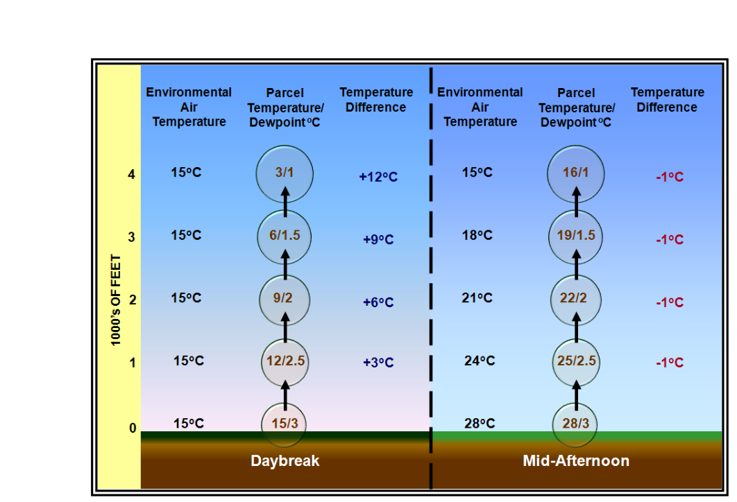
Every pilot has noticed that flying conditions in the early morning feel dramatically different from those on a summer afternoon. The runway density altitude is lower, the air is smoother, and towering cumulus are nowhere in sight — yet by mid-afternoon the same airport can be turbulent, hot, and threatening. These contrasts are the direct result of diurnal temperature variation: the predictable cycle of surface heating and cooling that repeats every 24 hours. Understanding the physical mechanisms behind this cycle, as explained in the FAA Aviation Weather Handbook (FAA-H-8083-28B), Chapter 5, equips pilots to anticipate daily changes in aircraft performance, turbulence, and convective activity before they ever leave the ground.
At its core, diurnal temperature variation is a competition between incoming solar energy and outgoing terrestrial energy. During daylight hours, the surface absorbs more energy than it loses; temperatures rise. After sunset — and often well before, once the sun drops low enough — the surface radiates more energy than it receives; temperatures fall. The magnitude of this daily swing depends on the type of surface, the transparency of the atmosphere, and the angle at which sunlight strikes the Earth.
The Energy Sources: Solar and Terrestrial Radiation
The sun emits radiation concentrated in short, visible wavelengths. The Earth's surface, being far cooler, re-emits that absorbed energy at much longer infrared wavelengths. This is the fundamental asymmetry of the radiation budget. Because the atmosphere is more transparent to incoming visible radiation than to outgoing infrared radiation, the surface can accumulate heat during the day and lose it relatively slowly at night — a greenhouse-style effect that sets the stage for the diurnal cycle.
The intensity of incoming solar radiation at the surface, called insolation, is governed by the solar zenith angle — the angle between the sun and the point directly overhead (the zenith). When the sun is directly overhead (solar zenith angle = 0°), its energy is concentrated on the smallest possible surface area and travels through the least atmosphere. As the sun moves toward the horizon, the same bundle of energy spreads over a larger area and must penetrate a longer path through the atmosphere, where it is scattered and absorbed. This is why mid-day heating is most intense, why summer days produce the greatest temperature swings, and why high-latitude locations experience less extreme heating than tropical ones.
How Heat Reaches the Air: Conduction and Convection
Solar radiation heats the solid or liquid surface directly, but the atmosphere above it is warmed indirectly through two sequential processes: conduction and convection.
Conduction is the molecule-to-molecule transfer of heat energy between substances in physical contact. Heat always flows from the warmer substance to the cooler one, and the rate of transfer depends on the temperature difference and on the thermal conductivity of the materials involved. Crucially, air is a very poor thermal conductor compared with solid materials. This means the ground cannot efficiently conduct heat directly into the overlying air column. Only a very thin layer of air immediately touching the surface is warmed by conduction.
Convection takes over where conduction leaves off. Because air is a fluid, the thin layer warmed by conduction becomes less dense than the air above it, becomes buoyant, and rises — carrying heat energy vertically through the atmosphere. This is the mechanism that creates thermals, which pilots flying sailplanes seek out and VFR pilots in light aircraft must anticipate as afternoon turbulence. Convection is by far the dominant pathway by which the surface transfers heat to the lower troposphere.
How Surface Type Shapes the Daily Temperature Swing
Not all surfaces heat and cool at the same rate, and this difference is one of the most operationally important concepts in weather for pilots. Two physical properties govern a surface's thermal response: specific heat capacity and thermal conductivity.
Specific heat capacity is the amount of heat energy required to raise the temperature of one gram of a substance by one degree. Water has the highest specific heat capacity of any common natural substance — approximately 4.18 J g⁻¹ K⁻¹. Quartz sand, by comparison, has a much lower specific heat capacity, roughly one-fifth that of water or less. This is why beach sand becomes scorchingly hot on a sunny afternoon while the ocean water nearby remains relatively cool: the same amount of solar energy produces a much larger temperature rise in the sand than in the water.
Beyond specific heat capacity, water bodies warm slowly for a second reason: incoming solar radiation penetrates water to significant depths, distributing heat energy through a large volume, while on land surfaces heat can only penetrate a shallow layer via the slow process of conduction. Water's fluid nature also allows convective mixing to distribute heat through great depths, far deeper than the slow conductive heating of soil. The result is that water exhibits high thermal inertia — strong resistance to temperature change — while land surfaces respond quickly.
Dark-colored surfaces such as asphalt absorb more radiation and warm faster than light-colored surfaces. Dry sand, with its low specific heat and low conductivity, heats rapidly. These local surface differences create significant horizontal temperature gradients — even within a single airport environment — that can generate localized convective currents and gusty afternoon winds.
The Diurnal Cycle: A Typical Day at an Inland Airport
The daily temperature cycle at a continental, inland location follows a recognizable pattern. Temperatures reach their minimum near sunrise, not at midnight, because the surface continues losing heat via radiation through the night until the moment solar input once again exceeds radiative loss. After sunrise, the surface heats progressively as the solar zenith angle decreases toward local noon. Surface temperature typically peaks in the early-to-mid afternoon — roughly one to two hours after solar noon — because it takes time for the surface heat to accumulate and transfer to the near-surface air. Temperatures then decline through the afternoon and evening, reaching their overnight minimum near the next sunrise. In desert and dry continental climates, this diurnal swing can be substantial, often on the order of many degrees in a single day. Along the coast or near large lakes, maritime influence moderates the swing to just a few degrees Celsius.
Why It Matters for Pilots
Density altitude: As surface temperature rises through the day, air density decreases. Density altitude climbs, reducing aircraft performance — longer takeoff rolls, slower climbs, degraded engine output. A high-elevation airport that is comfortably within performance limits at 0600 local time may be marginal or dangerous by 1400.
Convective turbulence and thermal activity: Once the surface heats sufficiently to create buoyant thermals, low-level turbulence intensifies. Afternoon flights at low altitude over dark, dry terrain can be rough; the same route flown before sunrise is typically smooth.
Convective weather development: Diurnal heating is the primary trigger for air-mass thunderstorms. Over land, these storms typically initiate in the early-to-mid afternoon, peak in the late afternoon or early evening, and diminish after sunset as surface heating ends. Coastal sea-breeze convergence zones, driven by the temperature contrast between land and water, also peak during the afternoon heating cycle.
Surface winds: Daytime heating generates a deeper, turbulent boundary layer and mixes higher-momentum air downward, increasing surface wind speeds. Overnight cooling stabilizes the boundary layer and surface winds often become light and variable. Pilots planning crosswind departures and arrivals benefit from knowing that wind speed and gustiness typically peak in the early-to-mid afternoon.
Land and sea breezes: The diurnal difference in heating rates between land and water drives a direct circulation. During the day, land heats faster, air rises over it, and cooler marine air flows inland as a sea breeze. At night, the land cools faster than the water, and the circulation reverses to a land breeze. Sea-breeze fronts can generate significant low-level wind shear and, if moisture is sufficient, afternoon convective showers along the coast.
Key Numbers and Rules
- Minimum daily temperature typically occurs near sunrise, not midnight.
- Maximum daily temperature typically occurs one to two hours after solar noon (early-to-mid afternoon).
- Solar zenith angle of 0° = maximum insolation; the sun is directly overhead.
- Specific heat capacity of water: ~4.18 J g⁻¹ K⁻¹ — roughly five times that of quartz sand, which is much lower.
- Heat penetration: solar heating penetrates soil only a shallow depth via slow conduction, while it penetrates water to much greater depths, aided by convective mixing.
- Air's thermal conductivity is among the lowest of common substances, making convection essential for atmospheric heat transport.
- Continental locations experience the largest diurnal swings; maritime locations (islands, coastal cities) experience the smallest.
Common Test Traps
- Minimum temperature at midnight: Students often assume the coldest point of the day is midnight because that is the farthest from noon. The correct answer is near sunrise, when cumulative radiative cooling reaches its maximum.
- Maximum temperature at solar noon: The surface continues absorbing more heat than it loses even after solar noon, so the temperature peak lags by one to two hours into the afternoon.
- Water heats faster than land: False — water's high specific heat capacity and deep mixing mean it heats and cools far more slowly than land, which is why maritime climates are mild and continental climates are extreme.
- Conduction as the primary atmospheric heat transfer mechanism: Because air is a very poor thermal conductor, convection — not conduction — dominates vertical heat transport in the atmosphere. Exams may try to get students to select conduction.
- Dark surfaces vs. light surfaces: Dark surfaces (asphalt runways, dark soil) absorb more radiation and generate more intense convective heating than light surfaces. This affects local turbulence and thermal strength over and downwind of specific terrain types.