One of the most practical skills a Part 107 remote pilot must master is reading a sectional aeronautical chart well enough to determine exactly which class of airspace sits above a proposed flight location — and at what altitude that airspace begins. Unlike manned aircraft pilots who may simply climb through one class into another, drone operators are tightly bound to altitude limits and geographic boundaries that are printed directly on the sectional. Get the symbology wrong, and you may unknowingly fly into controlled airspace without authorization, risking certificate action or worse. This article breaks down every airspace class boundary you'll encounter on a sectional, explains how to read it, and points out the traps that show up repeatedly on the FAA Part 107 knowledge test.
Sectional charts are published by the FAA at a scale of 1:500,000 (one inch equals approximately 6.86 nautical miles) and are updated every six months. They use a carefully standardized color and line system where each airspace class has its own unique visual signature. Learning those signatures — the specific magenta or blue colors, the solid versus dashed lines, and the altitude numbers printed nearby — is the foundation of every sUAS flight-planning decision.
How Airspace Classes Are Depicted
Class B Airspace
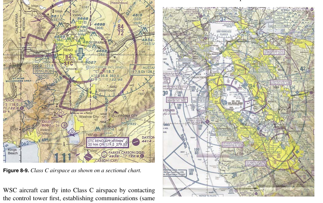
Class B airspace surrounds the nation's busiest airports. On a sectional chart it is drawn with solid blue lines that form a series of concentric rings, often described as an upside-down wedding cake. Each ring represents a separate segment with its own floor and ceiling altitude. Those altitudes are printed inside or adjacent to each ring in the format ceiling over floor — for example, 100/SFC means the floor is at the surface and the ceiling is 10,000 feet MSL (altitudes are in hundreds of feet, so 100 = 10,000 ft). Where you see SFC as the lower number, Class B touches the ground starting at the airport itself. The outermost rings often have floors well above the surface — sometimes 3,000 or 5,000 feet MSL — creating gaps underneath where operations may legally occur without Class B authorization, though other airspace classes (including Class D or Class E) may fill that gap. For Part 107 operations, any flight that would enter Class B requires prior FAA authorization, which in practice means using the LAANC system or DroneZone.
Class C Airspace
Class C airspace surrounds airports with an operational control tower and a radar approach control facility that handle a moderate level of commercial traffic. It is depicted with solid magenta lines arranged in two primary rings. The inner ring (typically a five-nautical-mile radius) generally extends from the surface to 4,000 feet above airport elevation (AGL), while the outer ring (typically ten nautical miles) has a floor above the surface — commonly 1,200 feet AGL — up to the same 4,000-foot-AGL ceiling. Altitudes are printed the same way as Class B: ceiling over floor in hundreds of feet MSL, with the airport elevation factored in. A remote pilot operating under Part 107 must obtain FAA authorization before flying in Class C airspace, including the area directly beneath the outer ring where the floor is above the surface.
Class D Airspace
Class D airspace is the box-shaped controlled zone around airports that have an operating control tower but do not qualify for Class C. On the sectional it appears as a dashed blue line forming a roughly circular boundary — usually a four-to-five-nautical-mile radius around the airport. The ceiling altitude is shown in a box next to the boundary, in hundreds of feet MSL, with a negative sign (e.g., [26] means the ceiling is 2,600 feet MSL). The floor is always the surface. Part 107 operators must obtain LAANC or DroneZone authorization before flying in Class D. Importantly, Class D exists only when the control tower is in operation; when the tower closes, the airspace typically reverts to Class E or G, often without any change to the chart itself. Always check NOTAMs and tower hours.
Class E Airspace
Class E is the most complex airspace class to read on a sectional because it can begin at different altitudes and is shown with multiple different symbols depending on its structure. Understanding its depictions is critical for Part 107 test success.
- Magenta vignette (shaded) boundary: A fuzzy, soft-edged magenta border indicates where Class E begins at 700 feet AGL — the airspace fades from magenta on the controlled side to white. This transition area is commonly drawn around instrument approach corridors near smaller airports.
- Blue vignette (shaded) boundary: A similar soft-edged border in blue indicates Class E beginning at 1,200 feet AGL. In practice, most of the contiguous United States that is not covered by the magenta transition area defaults to Class E starting at 1,200 feet AGL — this broad area is essentially invisible on the chart because it is the background default.
- Dashed magenta line: A dashed magenta boundary defines a Class E surface area — meaning Class E extends from the surface upward. These are typically drawn around airports that have instrument approaches but no operating control tower, protecting instrument operations all the way to the ground. This is not the same as a dashed blue line (which is Class D). The color is the differentiator.
- Class E Federal airways (Victor airways): Shown as light brown lines connecting VORs, these airways are 8 nautical miles wide (4 NM each side of centerline) and Class E from 1,200 feet AGL up to but not including 18,000 feet MSL.
For Part 107 operators whose ceiling is 400 feet AGL by default (or 400 feet above a structure if operating near one), most routine flights in the U.S. countryside will occur beneath Class E airspace that starts at 700 or 1,200 feet AGL — meaning no authorization is needed for those flights as long as no surface Class E or other airspace applies. However, near airports with dashed magenta Class E surface areas, authorization is required even at very low altitudes.
Class A Airspace
Class A airspace extends from 18,000 feet MSL up to and including 60,000 feet MSL (FL600) over the United States, including its territorial waters, per 14 CFR 71.33. It is not individually drawn on sectional charts because it covers everything uniformly. For Part 107 operations, Class A is effectively irrelevant since the regulatory ceiling for sUAS is 400 feet AGL — no drone operating legally will come anywhere near Class A.
Class G Airspace
Class G is uncontrolled airspace. It occupies the space from the surface up to wherever Class E begins (700 or 1,200 feet AGL depending on location). It has no specific boundary lines on the chart; it is simply the airspace that is left over when no controlled class is present. No FAA authorization is required for Part 107 operations in Class G, making it the default environment for many rural sUAS flights.
Why It Matters for Part 107 Operators
Under 14 CFR Part 107, a remote pilot in command must not operate in Class B, C, D, or surface Class E airspace without prior FAA authorization. The penalty for unauthorized airspace incursion can include certificate suspension or revocation and civil penalties. Because a drone at 300 feet AGL is well below the floor of most controlled airspace except where it descends to the surface near airports, the practical skill is identifying whether there is a surface-level controlled airspace boundary overlying your planned flight location. This requires you to zoom into the sectional and look carefully at the colors of the boundary lines nearest the airport.
Additionally, even in airspace classes that don't require authorization, other restrictions may apply — temporary flight restrictions (TFRs), special use airspace such as prohibited, restricted, warning, or military operations areas (MOAs), and national security areas. These are also depicted on the sectional with their own distinct symbology and must be checked separately.
Key Numbers and Rules
- Class B: Solid blue lines; altitudes in hundreds of feet MSL (ceiling/floor); requires authorization for Part 107.
- Class C: Solid magenta lines; standard dimensions ~5 NM inner ring SFC–4,000 AGL, ~10 NM outer ring; requires authorization.
- Class D: Dashed blue line; ceiling shown in brackets (e.g., [26] = 2,600 ft MSL); surface to ceiling; requires authorization; only active when tower is open.
- Class E surface area: Dashed magenta line; extends from surface up; requires authorization for Part 107.
- Class E at 700 ft AGL: Magenta vignette (shaded edge); no authorization needed if staying below 400 ft AGL in most cases.
- Class E at 1,200 ft AGL: Blue vignette or default background; generally no issue for Part 107 below 400 ft AGL.
- Class G: No symbol; no authorization needed; surface to Class E floor.
- Part 107 altitude ceiling: 400 feet AGL by default; up to 400 feet above a structure if within 400 feet of it.
Common Test Traps
- Magenta dashed vs. magenta vignette: A dashed magenta line is a Class E surface area requiring authorization. A soft, fading magenta edge is a 700-ft AGL Class E transition area that generally does NOT require authorization for low-altitude drone work. Many students reverse these.
- Blue dashed vs. blue solid: Dashed blue = Class D (tower airport). Solid blue = Class B (major hub). Confusing these will give you the wrong airspace class and the wrong authorization requirement.
- Class D disappears at night: If the control tower closes, Class D is no longer in effect — but the chart looks identical. Always verify tower operating hours and check NOTAMs before assuming Class D applies or does not apply.
- Altitude notation on Class B rings: The number on top is the ceiling, the bottom is the floor. Students often read these backwards and conclude there is more or less protected airspace than actually exists.
- Class G is not drawn: There are no lines on a sectional chart marking Class G boundaries. Students sometimes think an area with no lines is some kind of special zone. It simply means uncontrolled airspace up to wherever Class E begins — check the surrounding symbols to determine the Class E floor.