Before you ever leave the ground on a cross-country flight, your sectional aeronautical chart is telling you a story about the airspace you will cross. Scattered across every sectional are zones marked with magenta or blue hatching, bold labels like "R-2508" or "MOA," and altitude notations that can mean the difference between a routine flight and a violation—or worse, a mid-air conflict with a military jet. Learning to read these symbols quickly and accurately is one of the most practical skills a student pilot develops, and it is reliably tested on the FAA Private Pilot Knowledge Exam.
The FAA groups non-standard airspace that is set aside for specific, often hazardous activities under the umbrella term special use airspace (SUA). The Pilot's Handbook of Aeronautical Knowledge identifies six distinct categories of SUA, each with its own chart depiction, regulatory status, and operational implications. Understanding each type—not just memorizing a color—prepares you to make smart go/no-go and route decisions.
The Six Types and How Each Looks on a Sectional
Prohibited Areas
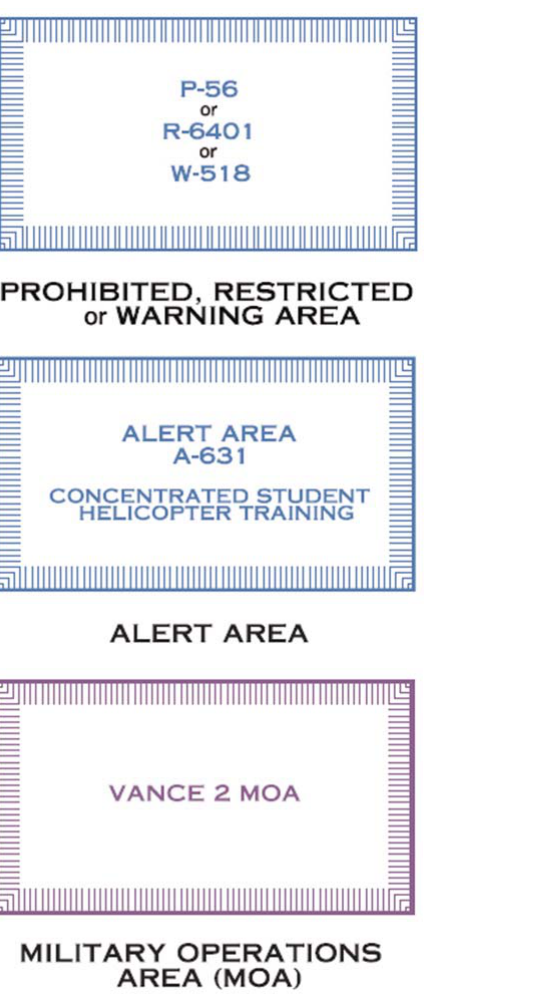
Prohibited areas are parcels of airspace where flight by civil aircraft is entirely forbidden at all times under 14 CFR Part 73. These exist over sites where even momentary penetration poses an unacceptable national security or safety risk—examples include the airspace over the White House (P-56A/B) and Camp David (P-40). On a sectional chart, prohibited areas appear as a blue hatched boundary with a bold blue label such as "P-40". The letter "P" is the first clue: P for Prohibited. Because the regulation carries no provision for ATC clearance or permission, there is simply no way for a civil pilot to legally enter a prohibited area—route around it, period.
Restricted Areas
Restricted areas are among the most commonly encountered SUA in the continental United States. They protect airspace where hazardous activities—artillery fire, aerial gunnery, missile launches—are conducted, but unlike prohibited areas, entry is not always off-limits. Under 14 CFR Part 73, restricted areas may be used by civil aircraft when they are not active, subject to ATC authorization. On a sectional, restricted areas are shown with a blue hatched boundary identical in style to prohibited areas, but the label begins with "R-" followed by a number (e.g., "R-2508"). The chart also shows the altitude limits: for example, "R-2508 / SFC-FL180" means the restricted area runs from the surface to Flight Level 180. Altitudes may be charted as AGL or MSL depending on the area; read the notation carefully. You should always check NOTAMs and contact the controlling agency or the applicable ATC facility to determine whether a restricted area is active before penetrating it.
Warning Areas
Warning areas exist in international airspace (beyond 3 nautical miles from U.S. shores) where hazardous activities similar to those in restricted areas take place. Because the U.S. cannot legally restrict foreign aircraft in international airspace, these zones are designated as warnings rather than restrictions. On a sectional, warning areas appear with a blue hatched boundary and are labeled with a "W-" prefix (e.g., "W-497"). Civil pilots are not legally prohibited from entering warning areas, but the FAA strongly cautions against it without obtaining all available information about the activity taking place. Common activities include air-to-air and air-to-ground weapons testing and supersonic flight.
Military Operations Areas (MOAs)
MOAs are established to separate military training activities—aerobatics, air combat maneuvering, low-altitude tactics—from IFR traffic. They do not prohibit VFR flight, but the FAA's guidance is direct: VFR pilots should exercise extreme caution when an MOA is active, because military aircraft may be operating at high speeds with limited ability to see and avoid. On a sectional, MOAs are depicted with a magenta hatched boundary and are labeled with a name and the word "MOA" (e.g., "TOMBSTONE MOA"). The associated altitude block and hours of operation are printed in a table in the chart's margin or legend. Before crossing an active MOA, contact the controlling agency (listed in the chart supplement) or the nearest FSS to determine activity status. When an MOA is inactive, IFR and VFR aircraft may transit without restriction.
Alert Areas
Alert areas inform pilots of areas where a high volume of pilot training or unusual aerial activity takes place. Unlike MOAs or restricted areas, alert areas do not segregate airspace—both civil and military pilots share the responsibility of collision avoidance within them. Alert areas appear on sectionals with a magenta hatched boundary and an "A-" label (e.g., "A-211"). You are legally permitted to fly through an alert area, but you must remain especially vigilant. Typical activities include heavy student pilot traffic near large flight training bases.
Controlled Firing Areas (CFAs)
Controlled firing areas are unique among SUA because they impose no charting requirements—you will not find a CFA boundary drawn on your sectional chart. Why? Because activities within a CFA must be suspended immediately whenever a spotter aircraft or radar indicates that an aircraft is approaching. The hazard, in other words, accommodates the pilot rather than the other way around. For this reason, you are unlikely to encounter a CFA question on the knowledge test that involves chart identification, but understanding why they are not charted is itself a test topic.
Reading Altitude Limitations on the Chart
Every SUA depiction that does appear on a sectional includes altitude information. You will typically see two numbers separated by a line or slash, such as "FL180 / 8,000 MSL" or "SFC / 10,000 MSL." The upper number (or notation) is the ceiling; the lower is the floor. "SFC" means the area begins at the surface. "AGL" means the altitude is measured above ground level, while "MSL" means it is measured from mean sea level. Always note whether the floor is at the surface—if so, you cannot fly under the area; you must fly around it or obtain the necessary clearance (if the type of SUA permits one).
Why Special Use Airspace Matters
SUA is not bureaucratic paperwork—it represents real hazards. A military fast jet performing an intercept training maneuver inside an active MOA may be traveling in excess of 500 knots. Artillery rounds fired within a restricted area climb to thousands of feet before descending. Unauthorized penetration of a prohibited area can result in intercept by armed military aircraft, emergency procedures, certificate action, and criminal charges under national security statutes. Even in a warning area, where no U.S. law prohibits civil flight, the risk of collision with a military aircraft conducting weapons testing is genuine. Pre-flight planning that identifies and accounts for every SUA along your route is not optional—it is a fundamental duty of command.
Key Numbers and Rules
- Prohibited areas (P-): No civil flight permitted at any time; blue hatched boundary.
- Restricted areas (R-): Entry requires ATC authorization when active; blue hatched boundary; altitude and hours on chart or supplement.
- Warning areas (W-): Beyond 3 NM offshore in international airspace; blue hatched boundary; civil pilots not legally prohibited but strongly cautioned.
- MOAs: VFR flight permitted but extreme caution required when active; magenta hatched boundary; contact controlling agency or FSS for status.
- Alert areas (A-): High volume of pilot training or unusual activity; magenta hatched boundary; all pilots share collision-avoidance responsibility.
- CFAs: Not charted on sectionals; activities cease when aircraft approach; no pilot action required.
- SUA floor labeled "SFC" means the area begins at ground level—no underfly option.
- Always cross-check SUA with current NOTAMs; scheduled times change and temporary activations occur.
Memory Aid
Use the phrase "Pretty Robust Warnings Make Aircraft Cautious" to remember the six SUA types in order: Prohibited, Restricted, Warning, MOA, Alert, Controlled Firing Area. Then pair color with restriction level: blue hatching = harder restriction (Prohibited, Restricted, Warning—the most dangerous or legally binding); magenta hatching = caution zones (MOA and Alert—active sharing or avoidance required). CFAs have no color because they have no chart symbol.
Common Test Traps
- Confusing blue and magenta hatching. Test questions often ask you to identify an area from a chart excerpt. Blue hatching = P, R, or W areas. Magenta hatching = MOA or Alert. Mixing them up is the most common error.
- Assuming restricted areas are always off-limits. Restricted areas are only legally closed to civil aircraft when active. A common distractor answer says you can never enter an R area; the correct answer is that you may enter with ATC authorization or when inactive.
- Thinking MOAs restrict VFR flight. MOAs do not legally prohibit VFR traffic—they only separate military traffic from IFR traffic. The FAA requires extreme caution, not avoidance, for VFR pilots in an active MOA.
- Forgetting that CFAs are not charted. A question may ask which type of SUA does not appear on a sectional chart. The answer is the Controlled Firing Area.
- Misreading altitude blocks. Students often reverse the ceiling and floor, or confuse AGL with MSL. Practice reading the altitude notation on sample chart excerpts until reading "SFC–10,000 MSL" is automatic.