When you unfold a VFR sectional chart for the first time, the overlapping rings, dashed and solid lines, and layers of magenta and blue can look like abstract art. But every line, color, and label on that chart carries a precise regulatory meaning. Understanding how Class B, C, D, and E airspace is depicted — and what each depiction obligates you to do before you fly through it — is one of the most heavily tested topics on the FAA Private Pilot Knowledge Test, and more importantly, one of the most safety-critical skills you will use on every cross-country flight.
This article walks through each airspace class in order from most restrictive to least, explaining the chart symbology, the associated communication and equipment requirements, and the practical "in the cockpit" decisions those symbols demand of you.
How Controlled Airspace Is Organized
The FAA divides the national airspace system into classes labeled A through G. For VFR pilots, the classes most frequently encountered at low and medium altitudes are B, C, D, and E. Class A (above 18,000 feet MSL) is exclusively IFR, and Class G is uncontrolled. Everything in between — B, C, D, and E — is controlled airspace where specific rules apply to VFR flight. The key distinctions between them come down to three things: the services ATC provides, the equipment your aircraft must carry, and what you must do before entering.
Class B Airspace: The Solid Blue Lines
Class B airspace surrounds the nation's busiest airports — think Chicago O'Hare, Los Angeles International, and Hartsfield-Jackson Atlanta. On a VFR sectional chart, Class B is depicted with solid blue lines. Because Class B is designed as a series of concentric "upside-down wedding cake" layers, you will see multiple solid blue circles of different diameters, each annotated with altitude ceilings and floors in the format ceiling/floor. For example, a label reading 80/30 means the floor of that ring is 3,000 feet MSL and the ceiling is 8,000 feet MSL. The innermost ring, directly over the primary airport, typically extends from the surface up to the Class B ceiling.
The regulatory requirement for Class B is unambiguous: you must receive an explicit ATC clearance before entering, not just establish radio contact. The controller must say something to the effect of "cleared to enter Class Bravo airspace." A frequency change instruction or traffic advisory alone does not constitute a clearance. Equipment required includes an operable two-way radio, a Mode C transponder (or ADS-B Out under 14 CFR 91.225), and, for student pilots, a specific logbook endorsement is required to operate at certain Class B primary airports listed in 14 CFR Part 91 Appendix D. The VFR weather minimums inside Class B are 3 statute miles visibility and clear of clouds — a notable exception to the standard cloud clearance rules that apply elsewhere.
Class C Airspace: The Solid Magenta Lines
Class C airspace surrounds airports with a control tower, an operational radar approach control (TRACON), and a significant volume of instrument operations — think Orlando International or Sacramento Executive. On the sectional chart, Class C is depicted with solid magenta lines forming two concentric circles. The inner circle typically has a 5 nautical mile radius and extends from the surface to 4,000 feet above the primary airport elevation. The outer circle typically has a 10 nautical mile radius, with its shelf typically beginning at 1,200 feet AGL and extending up to the same ceiling as the inner core — though actual floor altitudes for the outer shelf can vary by location, so always check the chart and Chart Supplement rather than assuming a fixed value. A third "outer area" extending to 20 nautical miles exists operationally but is not marked on the chart with the same solid lines.
Altitude information for Class C rings appears in the same ceiling/floor format as Class B. To enter Class C airspace, you must establish two-way radio communication with ATC — you do not need an explicit clearance, but you must make contact and receive a response that includes your call sign before entering. If the controller says "aircraft calling, stand by," that is considered two-way communication established; if the controller does not respond with your call sign, you may not enter. Required equipment includes a two-way radio and a Mode C transponder (or ADS-B Out). VFR minimums inside Class C are the standard 3 statute miles visibility, 500 feet below / 1,000 feet above / 2,000 feet horizontal from clouds.
Class D Airspace: The Dashed Blue Lines
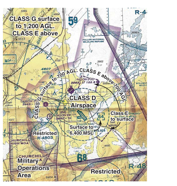
Class D airspace typically surrounds airports with an operating control tower that do not have the radar approach services needed for Class C. It is depicted on the sectional chart with a dashed blue line, usually forming a roughly circular boundary with a radius that extends about 4 to 5 nautical miles from the airport. The ceiling of Class D is typically 2,500 feet AGL, shown in a blue dashed box with the altitude in hundreds of feet enclosed in brackets, such as [25] meaning the ceiling is 2,500 feet MSL, since bracketed Class D ceiling figures on sectional charts are expressed in hundreds of feet MSL by convention. The floor is the surface.
Importantly, Class D airspace only exists when the associated control tower is in operation. When the tower closes, the airspace reverts to Class E or Class G — and the chart will typically note the hours of operation or reference the Chart Supplement. Before entering Class D, you must establish two-way radio communication with the tower. The same "call sign acknowledgment" rule applies as with Class C. No transponder is required solely for Class D (though many aircraft carry one), but you must have an operable radio. VFR weather minimums in Class D are 3 statute miles visibility, 500 feet below / 1,000 feet above / 2,000 feet horizontal from clouds.
Class E Airspace: Magenta and Blue Shading, Dashed Magenta Lines
Class E is the most widespread controlled airspace and the most visually complex on the chart. It has no single depiction; instead, several different chart symbols indicate Class E with different floor altitudes.
- Magenta vignette (shading): A fading magenta border around an airport indicates Class E airspace with a floor at 700 feet AGL. This is common around airports with instrument approaches that do not have a control tower. The shading is darker at the edges and fades inward.
- Blue vignette (shading): A fading blue border indicates Class E airspace beginning at 1,200 feet AGL. This is the default floor for Class E across most of the contiguous United States en route structure.
- Dashed magenta line: This marks the boundary of Class E airspace with a surface floor — meaning Class E extends all the way down to the ground inside the boundary. This is often used around airports that have instrument approaches but no operating control tower, providing protected airspace for arriving and departing instrument traffic near the surface.
- Hard blue border (solid line with tick marks): Occasionally seen where Federal airways or other Class E designations have a defined lateral edge at 1,200 feet AGL.
Class E requires no radio communication or clearance for VFR flight. However, the weather minimums change based on altitude: below 10,000 feet MSL, VFR minimums are 3 statute miles visibility and 500 below / 1,000 above / 2,000 horizontal from clouds. At and above 10,000 feet MSL, the minimums increase to 5 statute miles visibility and 1,000 below / 1,000 above / 1 statute mile horizontal from clouds.
Why It Matters
Misreading airspace boundaries is not a minor chart-reading error — it can result in an airspace violation, a pilot deviation, a potential certificate action, and, in busy terminal areas, a mid-air collision risk. ATC expects VFR pilots to self-separate and to know exactly where they are relative to every ring and boundary. Sectional charts are updated every 56 days precisely because these boundaries change. Always use a current chart and cross-reference it with NOTAMs and the Chart Supplement for tower hours and temporary flight restrictions.
Key Numbers and Rules
- Class B entry: Explicit ATC clearance required; Mode C/ADS-B Out required; VFR minimums — 3 SM, clear of clouds.
- Class C entry: Two-way radio communication (call sign acknowledgment) required; Mode C/ADS-B Out required; VFR minimums — 3 SM, 500/1,000/2,000 ft from clouds.
- Class D entry: Two-way radio communication required; no transponder mandate from the airspace alone; VFR minimums — 3 SM, 500/1,000/2,000 ft from clouds.
- Class E below 10,000 ft MSL: No communication required; VFR minimums — 3 SM, 500/1,000/2,000 ft from clouds.
- Class E at/above 10,000 ft MSL: No communication required; VFR minimums — 5 SM, 1,000/1,000/1 SM from clouds.
- Mode C veil: A transponder (Mode C or ADS-B Out) is required within 30 nautical miles of a Class B primary airport from the surface up to 10,000 feet MSL, regardless of whether you actually enter Class B.
- Class D tower hours: When the tower closes, check the Chart Supplement — airspace may revert to Class E or G, changing your weather minimums.
Memory Aid
A widely used mnemonic for airspace entry requirements is "Charlie Clears, Delta Dials, Bravo Begs Permission" — meaning Class C requires you to establish communication ("clear" to talk), Class D requires you to dial up the tower frequency and make contact, and Class B requires you to beg — that is, specifically request and receive — a clearance. While informal, this captures the ascending level of strictness: communication for C and D, explicit clearance for B.
Common Test Traps
- "Stand by" is good enough for Class C and D, but never for Class B. Many students think any response from ATC allows entry. For B, only an explicit clearance works. For C and D, a response that includes your call sign is sufficient.
- Solid blue vs. dashed blue: Solid blue lines are Class B; dashed blue lines are Class D. Students frequently swap these, especially under time pressure on the test.
- Magenta dashed vs. magenta shaded: A dashed magenta line indicates a Class E surface area (floor at the ground). A fading magenta vignette indicates Class E beginning at 700 feet AGL. These are completely different situations with different implications for how low instrument approaches are protected.
- Class D airspace when the tower is closed: If the tower shuts down at 10 PM and you arrive at 10:05 PM, you are no longer in Class D. The airspace has reverted — check what it becomes and adjust your weather minimums accordingly.
- Mode C veil vs. Class B boundary: The 30 NM Mode C/ADS-B veil around Class B primary airports is not the same as the Class B outer ring. You may be outside the depicted Class B boundary and still legally required to have a transponder operating due to the veil.