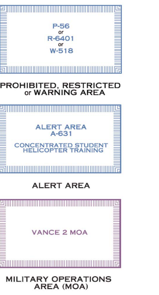
When you unfold a VFR sectional chart — or open its digital equivalent in a planning app — you will immediately notice that the airspace is not one uniform, featureless sky. Blocks of airspace are cordoned off for military training, weapons testing, skydiving, and other activities that make them hazardous or legally off-limits to unauthorized aircraft, including small unmanned aircraft systems (sUAS). The FAA calls these areas Special Use Airspace (SUA), and each type is drawn on sectional charts with a specific color, line style, and alphanumeric label. For a Part 107 remote pilot, being able to read these symbols fluently is not optional — operating in or near SUA without authorization can ground your operation, cost you your certificate, or put people at risk.
This article walks through every category of special use airspace you will encounter on a sectional chart, explains how to decode its label, and covers the practical and regulatory implications for sUAS operations. Everything here is grounded in the FAA's Aeronautical Chart User's Guide and the Pilot's Handbook of Aeronautical Knowledge (FAA-H-8083-25), as well as 14 CFR Part 73 (which governs restricted and warning areas) and Part 107.
The Six Categories of Special Use Airspace
The FAA recognizes six main types of special use airspace. Each has a different regulatory status, a different visual representation on the sectional, and a different implication for remote pilots. Understanding the distinctions between them is critical because some are absolute no-go zones while others require only awareness.
Prohibited Areas
Prohibited areas are depicted on sectional charts with a blue hatched boundary and are labeled with the letter P followed by a number — for example, P-40 (over Camp David) or P-56 (over the White House and Vice President's House). Flight of any aircraft, manned or unmanned, through a prohibited area is forbidden at all times under 14 CFR Part 73. There is no mechanism for ATC to grant entry; these areas exist by regulatory action and the prohibition is absolute. For a remote pilot, this means LAANC authorization does not open a prohibited area — you simply cannot fly there. The sectional legend identifies these with the blue hatch and the note that they are established for national security or other reasons requiring an outright flight ban.
Restricted Areas
Restricted areas are the most commonly encountered SUA on sectionals. They appear as blue hatched boundaries — similar in style to prohibited areas — and are labeled with the letter R followed by a number, such as R-2508 over Edwards Air Force Base in California. Restricted areas contain hazards to nonparticipating aircraft such as artillery fire, aerial gunnery, or guided missile launches. Flight within a restricted area is not always forbidden, but it requires permission from the controlling agency listed in the Chart Supplement (formerly Airport/Facility Directory). When a restricted area is active (hot), entry without clearance is prohibited. When it is inactive (cold), ATC may allow transit. Because sUAS are slow and often limited to low altitudes, the altitude floors and ceilings listed for each restricted area are important — sometimes only a narrow altitude band is restricted. Always check the Chart Supplement for hours, altitude limits, and the controlling agency's contact information.
Warning Areas
Warning areas look identical to restricted areas on the chart — blue hatching — but are labeled with the letter W, such as W-497. The critical difference is jurisdictional: warning areas extend from 3 nautical miles outward from the U.S. coastline into international waters, where the FAA has no authority to prohibit flight. However, the same hazardous activities — weapons testing, aerial gunnery — occur there. No clearance is legally required, but the FAA strongly cautions pilots against entering without coordinating with the controlling agency. For most Part 107 operations, warning areas are unlikely to be directly relevant because sUAS are operated within visual line of sight over land, but coastal operations near offshore warning areas deserve attention.
Military Operations Areas (MOAs)
Military Operations Areas are depicted with a magenta (fuchsia) hatched boundary on sectional charts, making them visually distinct from the blue-outlined prohibited and restricted areas. They are labeled by name rather than an alphanumeric code — for example, CHERRY MOA or SMOKY MOA — and that name is printed along the boundary. MOAs separate high-speed military flight training from IFR traffic and alert VFR pilots to potential hazards. Unlike restricted areas, flight is not prohibited in an MOA; VFR aircraft (and sUAS operating under Part 107) may legally enter. However, the density of fast-moving military aircraft makes the risk significant when the MOA is active. Always check NOTAMs and the Chart Supplement for the operating schedule and altitudes. For remote pilots, the low altitudes at which sUAS operate may actually place them below the floor of many MOAs, but you must verify the altitude range printed on the chart or in the supplement.
Alert Areas
Alert areas are shown with a magenta boundary and labeled with the letter A followed by a number, such as A-231. They notify pilots of a high volume of pilot training, unusual aerial activity, or a high concentration of student pilots. Flight is not restricted in alert areas — all aircraft, both participating and nonparticipating, are equally responsible for collision avoidance. For a remote pilot, an alert area is essentially a heads-up: expect unpredictable or student pilot traffic at lower altitudes and exercise extra vigilance. The remote-in-command must maintain situational awareness of other traffic at all times under 14 CFR 107.37, which requires sUAS to give way to all other aircraft.
Controlled Firing Areas (CFAs)
Controlled Firing Areas are unique in that they do not appear on sectional charts at all. CFAs contain activities — artillery, explosives — that could be hazardous to aircraft, but the controlling agency immediately suspends the activity when a spotter aircraft or radar detects an aircraft approaching. Because the hazard is suspended when aircraft are detected, there is no need to chart them or restrict airspace. However, sUAS are small and may not be detected by spotters or radar, which is an important safety consideration for remote pilots working near military installations even if no charted SUA is present.
Reading the SUA Label
Every SUA depicted on a sectional chart is labeled with key information printed inside or alongside the boundary. A typical restricted area label reads something like: R-2508 / 18000 MSL / TO UNLIMITED. This tells you the designation (R-2508), the lower altitude limit (18,000 feet MSL), and the upper limit (unlimited). A Part 107 remote pilot operating at or below 400 feet AGL is almost certainly below the floor of such an area, but always confirm. MOA labels include the name, and additional altitude and time information appears in the Chart Supplement. Never assume an SUA does not affect your planned altitude without checking all published information.
Why It Matters for Part 107 Pilots
Under 14 CFR Part 107.45, a remote pilot in command may not operate a small unmanned aircraft in prohibited or restricted areas without permission from the controlling or using agency. LAANC (Low Altitude Authorization and Notification Capability) provides near-real-time authorization for some controlled airspace classes, but LAANC does not provide authorization to enter prohibited or restricted areas. For those, you must contact the controlling agency directly. MOAs and alert areas do not require authorization but demand heightened risk management under the hazard identification and risk mitigation principles in FAA-H-8083-2, the Risk Management Handbook. An inadvertent incursion into active restricted airspace — even by an sUAS — constitutes an airspace violation and could result in certificate suspension or revocation, civil penalties, and in worst cases, collision with military aircraft.
Key Numbers and Rules
- Prohibited areas (P-): Blue hatch boundary; entry absolutely forbidden at all times; no authorization pathway for most areas.
- Restricted areas (R-): Blue hatch boundary; entry requires permission from controlling agency when active; check Chart Supplement for hours and altitudes.
- Warning areas (W-): Blue hatch boundary; located ≥3 NM offshore in international waters; no legal prohibition but hazardous; coordinate before entry.
- MOAs: Magenta hatch boundary; labeled by name; flight not prohibited but military traffic hazard; check NOTAMs and Chart Supplement for active times.
- Alert areas (A-): Magenta boundary; flight not restricted; high pilot training activity; all aircraft share collision avoidance responsibility.
- CFAs: Not charted; activity suspended when aircraft detected; sUAS may not be detected — exercise caution near military ranges.
- 14 CFR 107.45: Prohibits sUAS flight in prohibited or restricted areas without permission.
- 14 CFR 107.37: Remote PIC must yield right-of-way to all other aircraft.
Memory Aid
A classic mnemonic for the types of special use airspace is "P-ROW MAC" — though the standard FAA teaching tool for remembering all six SUA types is the phrase "PRoW MAC":
- P — Prohibited
- R — Restricted
- W — Warning
- M — MOA (Military Operations Area)
- A — Alert
- C — Controlled Firing Area
Work through the list in order of most to least restrictive, and recall that the last letter (C, for CFA) is the only one that does not appear on the chart at all — a useful anchor for exam questions that ask which type is not depicted on sectional charts.
Common Test Traps
- Prohibited vs. Restricted confusion: Both use blue hatching, but prohibited areas allow zero entry for anyone ever, while restricted areas may be transited when inactive with ATC permission. The FAA knowledge test exploits this visual similarity.
- MOA boundary color: Students frequently mark MOA boundaries as blue when they are actually magenta. Blue hatching signals a regulatory prohibition; magenta signals a caution or advisory area.
- CFAs not on the chart: A common distractor question asks which SUA type is charted on sectional charts — CFAs are the correct answer for the one type that is not charted.
- LAANC does not cover prohibited or restricted areas: Students sometimes believe that obtaining a LAANC authorization grants blanket airspace access. It does not open prohibited or restricted areas.
- Altitude floors matter: The test may describe an sUAS operating at 200 feet AGL beneath a restricted area with a floor of 5,000 feet MSL and ask whether a violation occurred. If the sUAS was below the floor, there is no violation — but you must read the altitude data on the label and in the Chart Supplement carefully, not assume.