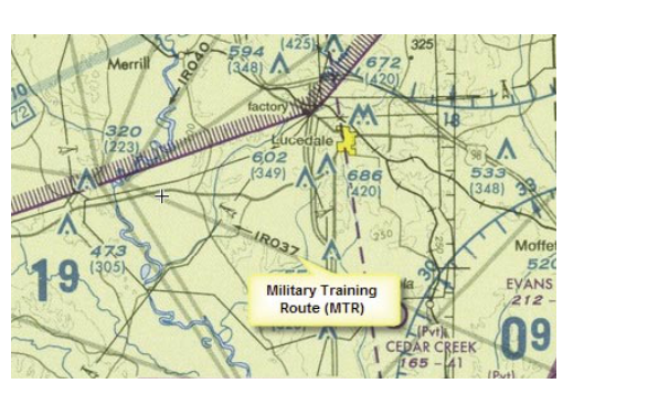
When you unfold a VFR sectional chart, you will notice thin gray lines crisscrossing the map, labeled with combinations of letters and numbers like "VR1205" or "IR207." These are Military Training Routes (MTRs) — corridors of airspace where military aircraft conduct high-speed, low-altitude training operations. The speeds involved can exceed 250 knots below 10,000 feet MSL, and sometimes approach 500 knots or more at very low altitudes. A jet fighter covering the ground at 400 knots gives a civilian pilot almost no time to see and avoid it. Understanding MTRs is not just a knowledge-test topic — it is a genuine safety imperative for any pilot flying cross-country under VFR.
MTRs are established under the authority of the Department of Defense in coordination with the FAA. They are described in detail in the Aeronautical Information Manual (AIM) and depicted on both VFR sectional charts and IFR en route low-altitude charts. The FAA's Pilot's Handbook of Aeronautical Knowledge (FAA-H-8083-25) covers MTRs as part of special-use and other airspace, while the AIM provides the definitive operational guidance pilots need to safely interact with these routes.
The Two Types of MTRs: IR and VR
Every MTR carries a two-letter prefix that tells you the most important thing about it: whether the route is flown under Instrument Flight Rules or Visual Flight Rules.
IR routes (Instrument Routes) are flown by military aircraft under IFR regardless of weather conditions. That means an IR route can be active in instrument meteorological conditions — in the clouds, in rain, in reduced visibility. As a VFR pilot, you might assume that because you can see in all directions, you are safe; but a military aircraft screaming down an IR route at 480 knots in IMC is invisible to you until it is far too late. IR routes have no weather minimums requirement for the military aircraft using them.
VR routes (Visual Routes) are flown under VFR, which generally requires the military aircraft operating on them to maintain visual meteorological conditions of at least a 3,000-foot AGL ceiling and 5 statute miles flight visibility, per DOD FLIP standards. This is a higher weather standard than the basic VFR minimums required of civilian pilots in many airspace classes, but it does not eliminate the collision risk — it simply means the military crew has some chance of seeing traffic, and vice versa.
How Route Numbers Tell You About Altitude
The number attached to an MTR — not just the letters — carries critical information about the route's altitude structure. This is one of the most important and most frequently tested facts about MTRs.
- Routes with 3-digit numbers (e.g., IR207 or VR318) indicate that one or more segments of the route extend below 1,500 feet AGL. This is the danger zone for most light general aviation aircraft flying at typical VFR cruise altitudes of 1,000 to 3,500 feet AGL.
- Routes with 4-digit numbers (e.g., VR1205 or IR4404) indicate that all segments of the route are conducted at or above 1,500 feet AGL. While still potentially conflicting with VFR traffic, these routes generally pose less risk to traffic below that altitude.
Remember: this altitude rule applies to both IR and VR routes equally. A four-digit VR route and a four-digit IR route both remain entirely at or above 1,500 feet AGL. A three-digit route of either type dips below that threshold somewhere along its path.
How MTRs Are Depicted on Sectional Charts
On a VFR sectional chart, MTRs appear as thin gray lines with directional arrows indicating the direction(s) of flight along the route. The route identifier (e.g., VR1205) is printed beside the line. Some routes are unidirectional — traffic flows only one way. Others are bidirectional, with arrows pointing in both directions, meaning military aircraft could be heading toward you from either end simultaneously.
The route lines do not show altitude directly on the sectional. To find the actual altitudes, widths, and times of use for a specific MTR, a pilot must consult the AP/1B — DOD Flight Information Publication (FLIP) Area Planning document, which is the official military publication listing detailed MTR information. As a practical alternative for preflight planning, Flight Service (1-800-WX-BRIEF) can provide current MTR activity information for any route you plan to cross, and this is the recommended step before penetrating MTR airspace on a VFR cross-country flight.
Widths and Dimensions
MTR widths vary considerably. Some narrow routes may be only a few miles wide on each side of the centerline, while others may extend many miles laterally. The route centerline shown on the chart represents the ground track, but military aircraft may maneuver up to the lateral limits of the route. Pilots should not assume that flying a mile or two off the charted centerline makes them safe — the aircraft may be operating anywhere within the defined width, which is only published in the FLIP document or available through Flight Service.
Vertically, route floors can extend from as low as 100 feet AGL on some training routes, particularly those used for terrain-following practice. Ceilings can reach up to 10,000 feet MSL or beyond on some IR routes. Again, the exact vertical limits are not depicted on the sectional itself.
Why MTRs Matter in Practice
The collision risk on an active MTR is extraordinarily high compared to normal airspace. Consider the closure rate: if a Cessna 172 cruises at 110 knots and a military jet travels at 480 knots, the combined closure rate head-on is 590 knots — nearly 10 miles per minute. Even under perfect VMC with unlimited visibility, by the time you see a fast military jet that is one mile away, you have roughly six seconds to react. In practice, visual detection rarely occurs at that range against a small, fast aircraft at low altitude with complex terrain as a background. The FAA's guidance on see-and-avoid (referenced in AC 90-48) acknowledges that human visual performance is limited, and high-speed military aircraft compound that problem significantly.
This is why MTR awareness and active avoidance — not just passive awareness — are the recommended strategy. If your route of flight crosses an MTR, here is the practical approach endorsed by FAA guidance:
- Identify all MTRs that your planned route will cross during preflight chart study.
- Call Flight Service or check NOTAMs to determine whether those routes are scheduled to be active during your flight window.
- If a route is active, consider timing your crossing to coincide with a lull in scheduled activity, or request a weather brief that specifically addresses MTR activation times.
- Cross MTRs at a 90-degree angle where possible to minimize time spent in the corridor.
- Maintain a sharp visual scan and consider announcing your position on the relevant CTAF or guard frequency (121.5 MHz) when crossing an active MTR in a remote area.
Key Numbers and Rules
- IR routes: flown under IFR; no weather minimums required; active in IMC possible.
- VR routes: flown under VFR; DOD FLIP standard minimums call for a ceiling of at least 3,000 feet AGL and visibility of at least 5 miles.
- 3-digit route numbers: at least one segment below 1,500 feet AGL.
- 4-digit route numbers: all segments at or above 1,500 feet AGL.
- Chart depiction: thin gray lines with directional arrows on VFR sectional charts.
- Altitude/width details: not shown on sectional; found in DOD FLIP AP/1B or via Flight Service.
- Speed potential: military aircraft may exceed 250 knots below 10,000 feet MSL when operating under specific military operations specifications or waivers; 14 CFR 91.117 speed limits generally apply to military aircraft as they do to civilian aircraft, but authorized exceptions may permit higher speeds on some MTR segments.
Memory Aid
A reliable way to remember the digit-altitude rule is: "3 digits = dips below; 4 digits = 1,500 or above." Think of it as: the shorter the number, the lower it goes. A three-digit route is "shorter" in number length and also shorter in altitude — it gets down low where you fly. A four-digit route stays high. This is one of the most commonly tested MTR facts on the FAA Private Pilot Knowledge Test.
For the IR/VR distinction, remember: "I" for Instruments — weather doesn't matter; "V" for Visual — must be VMC to fly it."
Common Test Traps
- Confusing IR and VR weather rules: The test may imply that VR routes are safe in IMC. They are not — VR routes require VMC. IR routes can be used in any weather.
- Assuming 4-digit routes are always safe: A 4-digit route is above 1,500 feet AGL on all segments, but that still intersects with typical VFR cruise altitudes — do not dismiss them as irrelevant.
- Thinking MTRs appear in full detail on the sectional: The sectional shows the route centerline and identifier only. Actual altitudes, widths, and operating times must be obtained from the FLIP or Flight Service.
- Confusing MTRs with MOAs or Restricted Areas: MTRs are not shaded or bounded like MOAs. They appear as lines, not areas, and are not restricted airspace — you are not prohibited from flying through them, but doing so without awareness can be fatal.
- Forgetting bidirectional routes: A route with arrows pointing both directions means military traffic may come from either end simultaneously. The test sometimes asks about this, and it is also a practical trap for pilots who only scan in one direction.