Clear air turbulence (CAT) is one of the most operationally significant hazards a professional pilot will encounter at high altitude, precisely because it arrives without any visible warning. No cumulonimbus towers, no precipitation echoes, no lightning—just smooth blue sky and then, in an instant, violent, chaotic motion. For ATP candidates and airline crew, understanding the meteorological origins of CAT, the tools available to detect its probability, and the specific techniques to avoid or penetrate it safely is not merely an exam requirement. It is a foundational safety competency.
What CAT Is and Where It Forms
The FAA's Aviation Weather Handbook (FAA-H-8083-28) defines clear air turbulence as turbulence occurring in air free of clouds or precipitation, typically at altitudes above 15,000 feet MSL, with the highest frequency found near the tropopause and at jet stream levels (generally around FL300–FL450). This range should be understood as a general, typical range rather than a precise defined boundary. The atmosphere does not need visible moisture to be violently disturbed. CAT results primarily from wind shear—the rapid change of wind speed or direction over a short distance—which generates Kelvin-Helmholtz instability, producing breaking waves and chaotic eddies at the shear boundary.
There are four principal environments where CAT develops with high frequency:
- Jet stream shear zones: The polar jet stream and subtropical jet stream both produce intense horizontal and vertical wind shear at their boundaries. Wind speeds can change by roughly 40 knots or more per 150 nautical miles horizontally, or by roughly 5-6 knots per 1,000 feet vertically. The greatest CAT probability is found just above and just below the jet core, and on the polar (cyclonic) side of the stream—not in the core itself, which tends to be laminar.
- Upper-level troughs and ridges: Areas of strong curvature in the upper-level flow, particularly where a jet stream accelerates into or out of a trough, produce divergence and convergence patterns associated with elevated CAT frequency.
- Mountain wave activity: When stable air crosses a significant mountain range at moderate to high speeds, vertically propagating gravity waves can generate severe or extreme CAT in the wave crests and rotor zones. Crucially, these waves can extend hundreds of miles downwind of the generating terrain, producing CAT over seemingly featureless terrain or open ocean far from the mountains themselves.
- Near the tropopause: The transition zone between the troposphere and stratosphere is marked by a sharp temperature inversion and frequently by large wind shear. The tropopause is not a fixed surface; it varies by latitude and season, sitting higher in the tropics and lower near the poles. Aircraft operating near this boundary are at elevated CAT risk.
Why Standard Airborne Radar Cannot Detect CAT
This is one of the most tested and most important facts about CAT: airborne weather radar is useless for detecting it. Weather radar operates by transmitting microwave energy and detecting the energy reflected back by water droplets or ice crystals. CAT occurs in air that is, by definition, free of such particles. There is nothing to reflect the radar beam. A perfectly clean radar scope provides zero protection against CAT at cruise altitude. Pilots who interpret a clear radar display as assurance of smooth air are making a potentially fatal reasoning error.
The same principle applies to satellite imagery used informally in the cockpit. A channel showing cloud tops may confirm a clear-sky region overhead, but it reveals nothing about the invisible shear layers in that clear air. Turbulence in any form cannot be directly observed remotely unless specific LIDAR or forward-looking turbulence detection equipment is installed—technology that remains rare and not universally available across the fleet.
Detection Resources: What Pilots Actually Use
Pilot Reports (PIREPs)
PIREPs remain the most timely and operationally specific CAT detection tool available. When a crew encounters turbulence, they are strongly encouraged—and in some operational contexts expected—to file a PIREP using the standardized intensity scale: light, moderate, severe, or extreme. The AIM provides detailed criteria distinguishing these levels based on aircraft reaction and occupant experience. A fresh PIREP from an aircraft at the same altitude on the same route, filed within the past hour, is the most reliable warning a dispatcher or pilot can receive. Soliciting PIREPs from ATC when forecast products are absent or ambiguous is a legitimate and important crew resource management action.
SIGMETs and AIRMETs
The National Weather Service issues turbulence SIGMETs for severe (intensity 3) or extreme (intensity 4) turbulence expected to affect a defined area and altitude band. AIRMETs—specifically AIRMET Tango—cover moderate turbulence over a wide area. Reviewing all current SIGMETs and AIRMETs is a required element of a proper preflight weather briefing for IFR and high-altitude operations. SIGMETs for CAT specifically are distinct from convective SIGMETs, which address thunderstorm-related turbulence.
Graphical Turbulence Guidance (GTG)
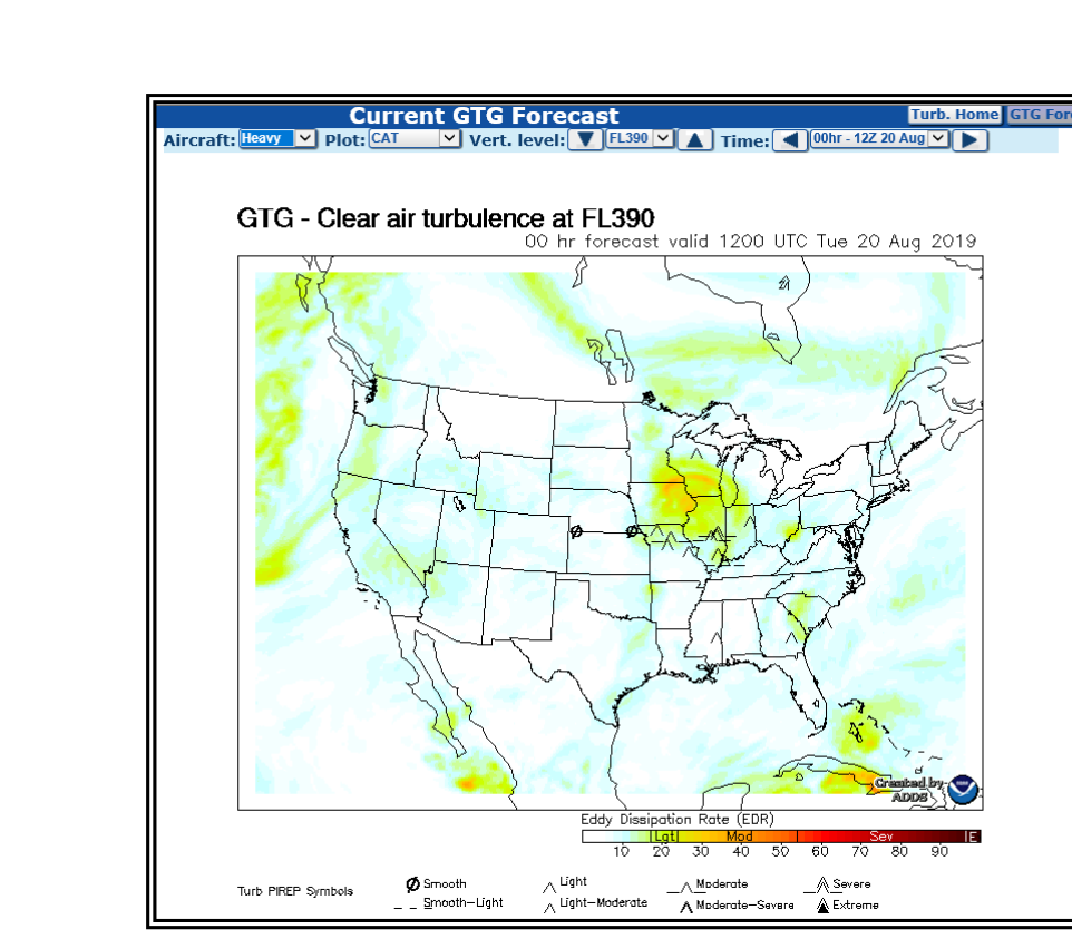
The Graphical Turbulence Guidance product, available through FAA-approved aviation weather services, uses numerical weather prediction model output to compute a composite turbulence index at multiple flight levels. GTG integrates multiple diagnostic algorithms—including wind shear, divergence, and deformation—to assign a probabilistic turbulence intensity estimate across the National Airspace System. It has demonstrated useful skill in identifying CAT regions, particularly when corroborated by PIREPs, and is routinely used in airline dispatch operations for route and altitude planning.
Jet Stream Analysis Charts
Upper-level wind charts and jet stream analysis products depict the position, altitude, and intensity of jet stream cores. By overlaying these on a planned route, dispatchers and pilots can identify where the route crosses or parallels jet stream boundaries—the highest-risk zones. As a rule of thumb: the stronger the jet core and the tighter the isotach gradient (the spacing of wind speed contours), the higher the CAT probability at the edges of that core.
Key Numbers and Rules
- CAT is most commonly found at altitudes above roughly 15,000 feet MSL, with peak frequency near the tropopause and jet stream levels (generally FL300–FL450).
- Highest CAT probability is above, below, and on the polar side of the jet stream core—not inside the core itself.
- Mountain wave CAT can propagate hundreds of miles downwind of generating terrain.
- When CAT is forecast or encountered, altitude changes of 2,000 to 4,000 feet often provide relief by exiting the narrow shear layer.
- Fly at the manufacturer-specified turbulent air penetration speed when CAT is anticipated; on some aircraft this may be published as VB, the design speed for maximum gust intensity, but not every AFM labels its penetration speed this way, so always follow the specific AFM guidance. This speed provides structural protection while maintaining control authority.
- Do not over-control: large, rapid flight control inputs during turbulence amplify structural loads beyond those caused by the turbulence itself.
- Severe turbulence is defined as causing large, abrupt changes in altitude or attitude; occupants are forced violently against restraints. Extreme turbulence is so intense that the aircraft is practically impossible to control and structural damage may occur.
Avoidance and Penetration Techniques
The preferred strategy is always avoidance. If preflight analysis or an en-route PIREP reveals CAT in a specific altitude band, request a route deviation or altitude change before entering the area. Since CAT layers are typically shallow—often only a few thousand feet thick—a modest altitude change frequently solves the problem. ATC turbulence deviations are routinely granted, and crews should not hesitate to request them.
When CAT is encountered unexpectedly, the immediate priorities are: establish the turbulent air penetration airspeed, follow AFM guidance on autopilot use—many AFMs recommend disconnecting the autopilot or switching from altitude-hold to attitude (pitch-attitude) hold during severe turbulence, since altitude-hold modes can command excessive control inputs while chasing altitude deviations in rough air—secure the cabin immediately via the fasten-seatbelt sign, inform ATC and request a new altitude or routing, and file a PIREP as soon as workload permits to protect subsequent aircraft. The NTSB has consistently found that unsecured occupants—often flight attendants caught in the aisle—account for the overwhelming majority of turbulence-related injuries aboard transport-category aircraft. Early, proactive use of the seatbelt sign is a direct, evidence-based injury prevention measure.
Common Test Traps
- Radar confirms smooth air: Completely false. Airborne weather radar detects precipitation, not shear or turbulence in clear air. A clean scope is not a guarantee of smooth flight.
- CAT is only a mountain hazard: False. Jet stream CAT develops independently of terrain and is found over oceans and flat plains. Mountain wave CAT is a separate, additive hazard.
- Fly faster to get through turbulence quickly: False and dangerous. Exceeding the turbulent air penetration speed dramatically increases structural loads. Slow to the manufacturer's recommended penetration speed.
- AIRMET vs. SIGMET intensity thresholds: Moderate turbulence = AIRMET Tango. Severe or extreme turbulence = SIGMET. Candidates frequently confuse these boundaries.
- CAT is always at jet stream altitude: False. Mountain wave activity generates CAT from near the surface upward through the stratosphere, and any level with strong wind shear is a candidate regardless of proximity to the jet core.