Among all the weather hazards cataloged in the Aviation Weather Handbook (FAA-H-8083-28), the embedded thunderstorm stands in a class of its own. A discrete cumulonimbus visible against a clear sky gives a crew the most fundamental avoidance tool available — eyesight. Strip that away with a thick overcast, widespread stratiform precipitation, or a mature frontal system, and you are left with a convective cell that generates hail, severe turbulence, structural icing, and lightning with zero visual warning. The aircraft can be cruising in what feels like routine IMC when it transitions, in seconds, into the interior of a violent storm. Understanding how to detect, interpret, and avoid embedded convection is not merely an ATP written-test topic; it is a core competency that the ACS traces directly to aeronautical decision-making under real operational risk.
Why Embedded Thunderstorms Are Uniquely Dangerous
A thunderstorm embedded in a stratiform cloud layer is dangerous for reasons that go beyond the storm itself. First, the surrounding cloud masks every visual cue — the anvil, the wall cloud, the precipitation shaft — that would otherwise trigger avoidance. Second, the meteorological environment that breeds embedded convection (warm, moisture-laden air overrunning a frontal boundary, or a slow-moving low with widespread lift) also produces icing, low ceilings, and reduced visibility that push crews deeper into IMC before they realize convection is nearby. Third, convective cells embedded in stratiform precipitation can develop with startling speed; a cell can intensify from moderate to severe in ten minutes or less, outpacing even the best situational awareness tools if crews become complacent.
The FAA-H-8083-28 specifically notes that thunderstorms embedded in large cloud systems are among the most hazardous phenomena in aviation precisely because normal visual strategies are unavailable. This is not a caveat — it is the central planning assumption every ATP crew must internalize on every flight that penetrates widespread IMC associated with frontal or large-scale lifting mechanisms.
How Airborne Weather Radar Works — and Where It Fails
The Physics of Radar Return
Airborne weather radar transmits microwave energy pulses and measures the energy reflected back by water droplets and ice particles. The critical principle, tested repeatedly on ATP-level knowledge exams, is that radar detects precipitation, not turbulence. The intensity of the return is governed primarily by droplet size and water content (reflectivity, expressed in dBZ). Large liquid water drops — characteristic of a convective cell's heavy rain core — produce strong returns. Dry ice crystals above the melting layer reflect far less energy. This means a violently turbulent glaciated storm top can produce a weak or even absent radar return, leading an unwary crew to interpret the area as safe when it is not.
Color Coding and Gain Management
Modern color weather radar displays use a standardized intensity scale: green for light precipitation, yellow for moderate, red for heavy, and magenta for extreme returns on systems that support a fourth color level. At the ATP level, yellow must be treated with significant caution, and red returns in IMC should be considered impassable. Gain management — the process of adjusting the radar receiver's sensitivity — is essential to extract accurate information. Excessive gain introduces ground clutter and precipitation clutter that can obscure cell cores; insufficient gain may render light but significant returns invisible. The pilot must actively manage gain rather than leave it on automatic, especially during en route penetration of widespread precipitation areas.
Antenna Tilt and Range Selection
Antenna tilt is one of the most operationally important and most frequently mismanaged radar controls. Tilting too high samples the cold, glaciated tops of a cell and shows a weak return for what may be a violent storm below. Tilting too low at long range drives the beam into terrain returns, masking weather. The correct technique involves systematic tilt management: sweep low at close range to see the cell base and rain core, then tilt upward to examine storm tops and assess vertical extent. Range selection matters equally — at 200 nautical miles, a return that looks manageable may resolve into a solid line of red at 40 miles.
Radar Attenuation — The Hidden-Cell Trap
Attenuation is the single most dangerous limitation of airborne weather radar and generates some of the most reliably tested questions in ATP meteorology. When the radar beam passes through a region of heavy precipitation, a significant portion of the energy is absorbed and scattered before it can reach whatever lies behind that cell. The result is that a more intense storm hidden behind the first cell appears as a weak return — or no return at all — on the display. A crew seeing what looks like a corridor of lighter returns between two red cores may be looking directly at an attenuated shadow cast by one of those cores. A radar gap is not a safe corridor; it may be a concealed, more intense cell. The only way to confirm that a gap is real is to verify from multiple tilt angles and, ideally, cross-check with ground-based radar if time and planning permit.
Ground-Based Radar and Datalink Weather
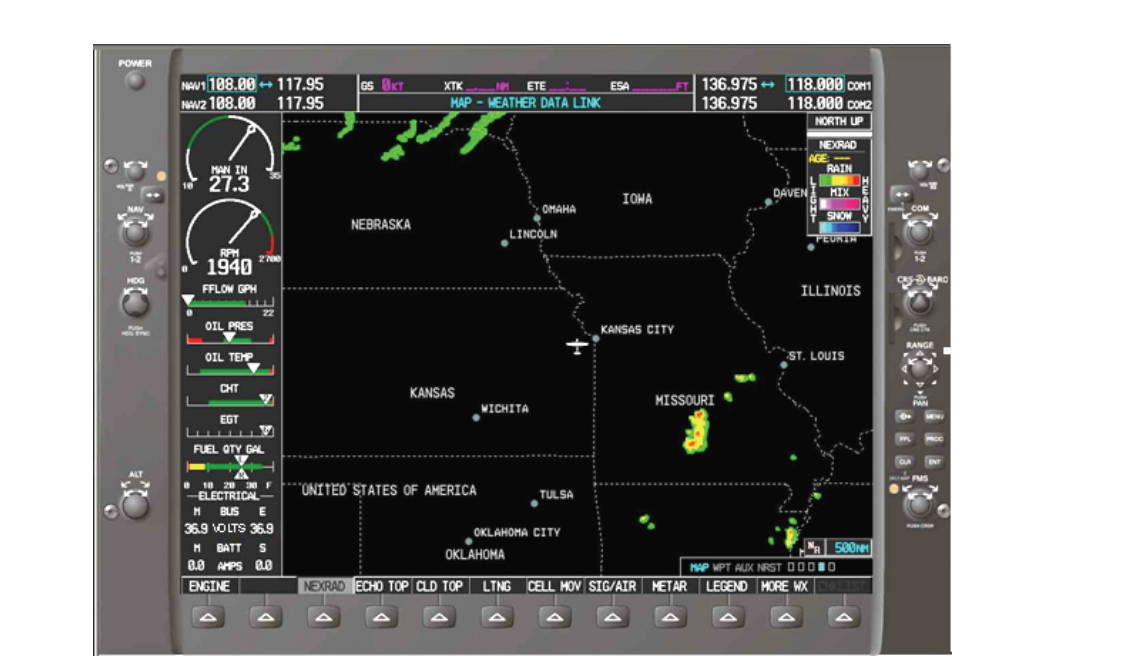
NEXRAD-derived datalink weather displayed on a cockpit moving map or multifunction display is an enormously powerful strategic tool — and a genuinely dangerous tactical crutch. The FAA is explicit on this point: datalink weather products carry an inherent time delay that can range from several minutes to fifteen minutes or more between the time the NEXRAD radar scans a volume of atmosphere and the time that picture appears on the cockpit display. A convective cell can intensify dramatically, propagate tens of miles, or spawn a new cell entirely within that window. Using datalink imagery for tactical, moment-to-moment deviation decisions in IMC violates the fundamental purpose of the product. Its appropriate use is pre-departure planning, en route strategic routing to remain clear of convective areas, and big-picture situational awareness — never a substitute for airborne radar in real-time avoidance.
Lightning Detection Systems
Passive lightning detection systems — commercially known by names such as Stormscope and Strikefinder — sense the electromagnetic discharge of lightning strikes and plot them on a cockpit display. Unlike radar, they do not depend on precipitation reflectivity, so they can detect electrically active cells even when radar returns are weak due to glaciation or attenuation. Their primary limitation is bearing accuracy: at longer ranges, electromagnetic bearing errors can place a strike 20 or more degrees off its true position, potentially misrepresenting the location of a cell. Lightning detectors and airborne radar are complementary — when a radar gap coincides with a cluster of lightning strike symbols, the combination is a strong indicator of an attenuated, active cell rather than a genuine gap in convection.
Thunderstorm Avoidance and Inadvertent Penetration
Avoidance Priorities
The overarching ATP principle is unambiguous: do not penetrate a thunderstorm. Avoidance begins long before the aircraft is close to the hazard. During preflight, forecasts, SIGMETs (particularly convective SIGMETs issued by the Aviation Weather Center), PIREPs, and NEXRAD composites establish where embedded convection is likely along the route. In flight, the crew should request deviations from ATC early — well before the radar picture demands an immediate turn — to preserve options and keep the aircraft clear of areas where attenuation could be hiding the worst conditions.
Inadvertent Penetration Procedures
When inadvertent penetration of a thunderstorm occurs, established guidance requires an immediate power reduction to the published turbulence penetration speed — commonly designated VA or VB depending on the aircraft's flight manual — which is specifically structured to balance gust load protection against the need for adequate control authority. Wings should be leveled. The autopilot may be used if the aircraft flight manual supports it; many modern transport aircraft are designed with autopilots that handle turbulence penetration effectively. Critically, altitude must not be chased aggressively. Updrafts and downdrafts inside a thunderstorm can move an aircraft thousands of feet per minute; attempting to hold altitude with large pitch and power changes amplifies structural loads. Maintain pitch attitude, accept altitude excursions, and fly through. Attempting a 180-degree turn inside an active cell prolongs exposure and imposes additional maneuvering loads on an already-stressed airframe.
Key Rules and Numbers
- Minimum lateral clearance advisory: The AIM recommends remaining at least 20 nautical miles laterally from a severe thunderstorm (AIM 7-1-28); greater distances are preferred for severe or extreme cells.
- Convective SIGMET issuance: Convective SIGMETs are issued for tornadoes; lines of thunderstorms at least 60 nautical miles long affecting at least 40% of the line; areas of thunderstorms covering at least 3,000 square miles affecting at least 40% of the area; and embedded, severe, or frequent thunderstorms. Severe thunderstorm criteria within these definitions include surface winds of 50 knots or greater or surface hail 3/4 inch or greater. Convective SIGMETs are valid for 2 hours.
- Datalink delay: FAA guidance (AIM 7-1-11; AC 00-45) indicates NEXRAD datalink imagery in the cockpit can be several minutes to fifteen minutes or more old; treat it as a planning tool, never a real-time deviation tool.
- Radar color scale: Green = light, Yellow = moderate, Red = heavy, Magenta = extreme (where supported). Yellow in IMC demands active avoidance planning.
- Attenuation rule: Never assume a radar gap between two cells is penetrable; treat gaps in heavy returns with the same suspicion as red returns.
Common Test Traps
- Radar detects turbulence directly. False — radar detects water droplets. Severe turbulence in dry, glaciated storm tops or in clear air adjacent to convection produces no radar return.
- A gap between red returns is safe to fly through. False — attenuation from the closer cell may be masking a hidden, more intense storm.
- Datalink NEXRAD provides real-time avoidance guidance. False — the FAA explicitly warns that inherent delays make datalink weather unsuitable for tactical, in-flight thunderstorm avoidance.
- During inadvertent penetration, altitude must be maintained at all costs. False — attitude control takes priority; chasing altitude in a thunderstorm aggravates structural loads.
- Lightning detectors replace airborne radar in IMC convection avoidance. False — they are complementary tools; lightning detectors have bearing error limitations and do not provide the precipitation intensity picture that radar does.
- Turning around is always the best response to inadvertent penetration. False — a 180-degree turn inside an active cell may increase total exposure time and structural stress; maintaining controlled flight through is often the safer option depending on penetration depth.