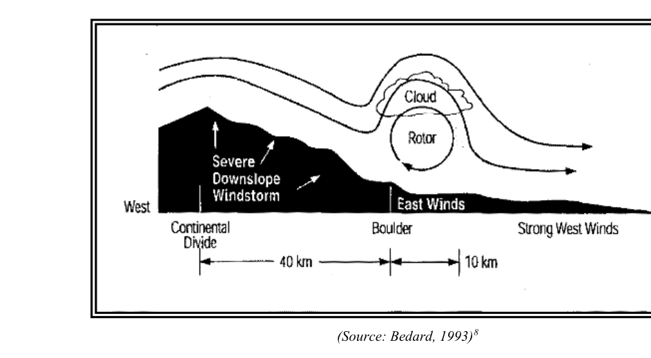
When stable air flows across a mountain ridge at sufficient speed, it can generate a series of powerful standing waves on the downwind (lee) side — a phenomenon the FAA Aviation Weather Handbook (FAA-H-8083-28) identifies as one of the most dangerous forms of atmospheric turbulence pilots encounter. Unlike convective turbulence, mountain wave activity is often invisible, can persist for hours or days, and routinely affects aircraft at cruise altitude hundreds of miles from the nearest terrain. For Airline Transport Pilot candidates, a thorough understanding of wave mechanics, rotor zone dynamics, and the operational decisions they demand is essential both for the written test and for safe high-altitude operations.
How Mountain Waves Form
Think of mountain wave development the way you would ripples forming downstream of a submerged boulder in a fast-moving river. The mountain ridge is the obstacle; the atmosphere is the river. When the flow is just right, the air does not simply separate and reattach over the ridge — instead it oscillates in a train of waves that can extend hundreds of miles downwind and propagate well into the lower stratosphere.
Three atmospheric ingredients must align for a well-organized wave to develop:
- Wind speed: FAA-H-8083-28 identifies approximately 25 knots or more at ridge level as a threshold for significant wave generation. Lighter winds tend to produce only weak, poorly organized oscillations.
- Wind direction: Flow must be within roughly 30 degrees of perpendicular to the ridge axis. Winds that run parallel to the ridge do not provide the necessary uplift and displacement.
- Atmospheric stability profile: A stable layer at or just above ridge-top altitude, sandwiched between less-stable layers above and below, creates the ideal waveguide. The stable layer resists vertical displacement, so once the air is forced upward by the ridge, buoyancy restores it — but the momentum carries it past the equilibrium point, and oscillation begins.
When all three conditions exist, the displaced air rebounds in a series of crests and troughs downwind. Each crest is a region of powerful updrafts; each trough contains equally powerful downdrafts. Extreme mountain wave events have produced very strong vertical velocities capable of exceeding the maximum climb capability of transport-category aircraft, though the FAA Aviation Weather Handbook does not publish a specific numeric benchmark for this. A crew experiencing a strong wave downdraft may find the aircraft descending at full thrust with the altimeter unwinding, while the attitude indicator shows a seemingly normal pitch.
Anatomy of the Wave System
Wave Crests and Lenticular Clouds
At each wave crest, air rises and cools to the dew point. If moisture is present, a lenticular cloud (altocumulus standing lenticular, or ACSL) forms — a smooth, lens-shaped cloud that appears stationary because air flows through it continuously, condensing on the upwind side and evaporating on the downwind side. Multiple lenticular clouds stacked vertically are sometimes called a pile d'assiettes (stack of plates). A cap cloud may form draped over the summit itself, obscuring terrain and marking the initial uplift. Lenticular clouds are a reliable visual warning of wave activity, but they require moisture to form. In the arid western United States, waves of equal or greater intensity often exist in completely clear air.
The Rotor Zone
The single most hazardous element of the mountain wave system is the rotor — a violently turbulent, cylindrical circulation of air that develops beneath each wave crest, typically at or below the height of the ridge. Picture a horizontal vortex rolling along the surface: the top surface moves in the direction of the prevailing wind, while the underside moves against it. The turbulence inside the rotor can reach extreme intensity (the FAA's highest category), capable of causing structural damage, immediate loss of control, and sudden, violent altitude and airspeed excursions within seconds.
If moisture is present, a rotor cloud — ragged, churning, and clearly different from the smooth lenticular above it — marks the rotor's location. The rotor cloud is the visual counterpart to the rotor, just as the lenticular is the counterpart to the wave crest. A pilot flying a visual approach or maintaining low-altitude terrain clearance on the lee side of a ridge may enter the rotor with no warning other than a sudden onset of extreme turbulence. The proximity to terrain compounds the danger enormously.
Clear-Air Turbulence and the Radar Trap
Mountain wave turbulence and its associated clear-air turbulence (CAT) produce no radar return. Airborne weather radar detects precipitation-sized water droplets, not turbulence itself. A completely clear radar display in mountainous or post-mountainous terrain provides no assurance of smooth air. This distinction is among the most frequently tested points on the Airline Transport Pilot written examination and is operationally critical: crews who rely on radar to identify turbulence risk being surprised by severe or extreme wave turbulence in apparently clear skies.
Geographic Extent and Altitude Range
A common misconception is that mountain wave effects are confined to the immediate vicinity of the generating ridge. FAA-H-8083-28 and operational experience both confirm that wave trains routinely propagate hundreds of miles downwind and can reach altitudes of 40,000 feet or higher. Aircraft operating at flight levels well above the terrain and far removed from the mountains may still encounter significant wave turbulence. The Rocky Mountains, Sierra Nevada, Appalachians, and Cascades are all prolific wave generators, but similar phenomena occur over any substantial ridge worldwide.
Weather Products and Pilot Reports
Several FAA-recognized weather products address mountain wave hazards:
- SIGMET (Significant Meteorological Information): Issued for severe or extreme turbulence, including mountain wave activity, affecting all aircraft. A Mountain Wave SIGMET demands immediate attention during flight planning and in-flight decision making.
- AIRMET Tango: Issued for moderate turbulence, including turbulence associated with mountain waves, affecting all aircraft.
- AIRMET Sierra: Covers IFR conditions and mountain obscuration — relevant when cap clouds or rotor clouds reduce visibility and ceiling near terrain.
- PIREPs (Pilot Reports): The single most timely and geographically specific source of real-time wave information. Because waves can be invisible and numerical forecast models sometimes underpredict wave intensity, pilot reports from other flights on the same route are invaluable. Filing PIREPs when encountering wave turbulence benefits all subsequent traffic.
- Graphical Turbulence Guidance (GTG): An algorithmically generated product available through aviation weather services that can help identify areas of likely CAT, including mountain wave CAT, though PIREPs remain the ground truth.
Operational Procedures and Best Practices
When mountain wave activity is forecast or known, the following procedures — consistent with FAA guidance and good airmanship — apply:
- Use turbulence penetration speed (VB): If significant turbulence is anticipated, slow to turbulence penetration speed (VB) before entering the affected area. VB is the design speed for maximum gust intensity and is distinct from maneuvering speed (VA); slowing appropriately minimizes structural loads and reduces the risk of exceeding design limits during sudden gust encounters.
- Cross ridges at a 45-degree angle: Mountain flying technique generally recommends a quartering crossing angle, which allows a faster escape turn away from terrain if severe turbulence or a downdraft is encountered near the ridge.
- Maintain adequate ridge clearance: General mountain flying guidance suggests crossing with at least 1,000 to 2,000 feet of clearance above ridge level depending on conditions, with more strongly preferred when wave activity is suspected. This keeps the aircraft farther from the rotor zone and provides altitude margin if a downdraft is encountered.
- Avoid the lee side at low altitude: The rotor zone is most intense close to the ridge and at low altitude on the downwind side. Low-altitude operations — including visual approaches, medevac flights, and terrain-following profiles — in the rotor area carry extreme risk.
- File and solicit PIREPs: Before departure, obtain all available PIREPs for the route. In flight, contribute your own observations so other crews can benefit.
- Monitor AIRMETs and SIGMETs continuously: Conditions can change between your preflight weather briefing and your time over the mountains. In-flight weather updates through the appropriate communication facilities are essential.
Key Numbers and Rules
- Wind speed threshold for significant wave development: approximately 25 knots at ridge level
- Wind angle criterion: within 30 degrees of perpendicular to the ridge
- Rotor location: at or below ridge height, on the lee side, beneath each wave crest
- Wave downwind extent: can reach hundreds of miles downwind of the generating ridge
- Altitude extent: can reach stratospheric levels (40,000 feet and above)
- Turbulence intensity in rotor: up to extreme — the highest FAA category
Common Test Traps
- Rotor altitude: Exam scenarios may describe the rotor as being at wave crest level or above the ridge. The rotor forms below the wave crest at or below ridge height — this is consistently tested.
- Radar reliance: Mountain wave turbulence and CAT produce no radar return. A clear radar display does not indicate smooth air in or downwind of mountainous terrain.
- Wave extent: Questions may imply wave effects are limited to the mountains themselves. Waves propagate hundreds of miles downwind and affect aircraft far from any visible terrain.
- Clear-air waves: Lenticular and rotor clouds require moisture. In dry conditions, severe wave turbulence can exist with no clouds whatsoever — hence the absolute reliance on PIREPs and forecasts rather than visual observation alone.
- Wind speed minimum: 25 knots at ridge level is the recognized threshold. Students sometimes cite lower values; waves generated by lighter winds are generally too weak to be significant hazards.
Memory Aid
"Lenticular = Wave Crest Warning / Rotor Cloud = Extreme Danger Below / Clear Sky = No Guarantee" — lenticular clouds mark each wave crest and indicate turbulence is present in the wave; ragged rotor clouds directly beneath mark the most violent region of the entire wave system; but both the wave and the rotor can exist with no clouds at all in dry air. Always consult PIREPs, AIRMETs, and SIGMETs rather than relying on visual observation of clouds to confirm or deny wave activity.