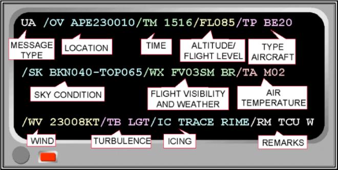
No weather sensor network can match the density of aircraft flying through the atmosphere every day. A Pilot Weather Report — universally called a PIREP — is an in-flight observation made by a pilot and relayed to an air traffic facility or Flight Service Station (FSS) for distribution to other pilots and meteorologists. Because PIREPs describe what is actually happening at altitude right now, they are among the most operationally valuable weather products available to any pilot planning or conducting a flight.
For the FAA knowledge test and, more importantly, for real-world decision-making, you need to understand the two types of PIREPs, how each field in the encoded report is read, what the intensity scales mean, and where the gaps and limitations lie. This article walks through all of it.
Two Types of PIREPs: UA and UUA
The FAA classifies PIREPs into two categories based on the urgency and severity of what is being reported.
A routine PIREP is identified by the header UA. It covers ordinary flight conditions — perhaps a smooth ride at cruise altitude, a cloud base, or light turbulence. Routine PIREPs are filed voluntarily and are transmitted on a scheduled basis alongside other weather products.
An urgent PIREP carries the header UUA. It is filed and transmitted immediately when a pilot encounters conditions that pose a significant hazard to other aircraft. The FAA requires that urgent PIREPs be issued whenever a pilot reports any of the following: severe or extreme turbulence, severe icing, a tornado, waterspout, funnel cloud, low-level wind shear (LLWS), or hail. Because these hazards develop and move quickly, the urgent designation ensures other pilots receive the information with minimum delay.
The Standard PIREP Encoding Format
Every PIREP, routine or urgent, follows the same structured format. Each element is introduced by a two- or three-letter abbreviation called a descriptor, followed by a slash. Knowing these descriptors lets you decode any PIREP in seconds.
- UA or UUA — Type of PIREP (routine or urgent). Always the first element.
- /OV — Location. Expressed as a VOR identifier, a VOR radial and distance (e.g., OV ABC045025 means 25 NM on the 045° radial from ABC VOR), or as a fix/waypoint name.
- /TM — Time. Given in UTC (Zulu) using four digits, e.g., /TM 1530.
- /FL — Altitude or flight level. Altitude in hundreds of feet MSL, e.g., /FL085 means 8,500 feet MSL. UNKN is used if altitude is unknown.
- /TP — Type of aircraft, e.g., /TP C172. This is important context — a Boeing 737 and a Cessna 172 experience turbulence very differently, and knowing aircraft type helps the reader calibrate the report.
- /SK — Sky condition. Cloud layers expressed similarly to METARs: base and top of layers, coverage, and whether the sky is clear.
- /WX — Flight visibility and weather. Uses standard weather symbols such as FV for flight visibility, RA for rain, SN for snow, FG for fog.
- /TA — Air temperature in degrees Celsius. Temperature is always reported in Celsius in PIREPs.
- /WV — Wind direction in degrees true and speed in knots, e.g., /WV 27045KT.
- /TB — Turbulence. Intensity, whether it is in cloud or clear air (CAT for clear-air turbulence), and duration or frequency.
- /IC — Icing. Type and intensity.
- /RM — Remarks. Free-text field for anything not captured above, such as the location of a mountain wave, a pirouetting altimeter, or the absence of forecast hazards.
Not every PIREP will contain every field. A report filed primarily to describe an icing encounter may omit wind and temperature if the pilot did not record them. The /OV, /TM, /FL, and /TP fields are considered essential — the FAA expects them in every report because without location, time, altitude, and aircraft type, the report loses most of its value.
Turbulence Intensity Scale
The FAA defines turbulence intensity in four levels, and you must know them cold for both the test and practical flying.
- Light — Slight, erratic changes in altitude or attitude. Occupants feel slight strain against seat belts. Loose objects may shift slightly. Intensity symbol: LGT.
- Moderate — Similar to light but of greater intensity. Changes in altitude or attitude occur but the aircraft remains in positive control at all times. Occupants feel definite strain against seat belts. Unsecured objects are dislodged. Intensity symbol: MDT.
- Severe — Large, abrupt changes in altitude or attitude. Aircraft may be momentarily out of control. Occupants are forced violently against seat belts. Unsecured objects are tossed about. This is a UUA trigger. Intensity symbol: SEV.
- Extreme — The aircraft is violently tossed about and practically impossible to control. Structural damage is possible. Intensity symbol: EXTRM. Also a UUA trigger.
Two additional terms describe frequency, not intensity: Occasional (less than one-third of the time), Intermittent (one-third to two-thirds of the time), and Continuous (more than two-thirds of the time). A turbulence entry might read /TB MDT-SEV OCNL CAT, meaning moderate to severe, occasional, clear-air turbulence.
Icing Intensity Scale
Like turbulence, icing is reported in standardized intensity levels.
- Trace — Ice becomes perceptible. Rate of accumulation is slightly greater than sublimation. Not hazardous unless encountered for more than one hour.
- Light — The rate of accumulation may create a problem if flight is prolonged in the condition (more than one hour). Anti-icing equipment prevents accumulation or eliminates it.
- Moderate — The rate of accumulation is such that even short encounters are potentially hazardous and use of de-icing or anti-icing equipment, or diversion, is necessary.
- Severe — The rate of accumulation is such that anti-icing/de-icing equipment fails to reduce or control the hazard. Immediate diversion is necessary. Severity triggers a UUA.
Icing type is also reported: RIME (opaque, rough ice that forms quickly in supercooled water droplets — common in stratiform clouds), CLEAR (smooth, dense, hard ice that forms when large supercooled droplets spread out before freezing — common in cumuliform clouds and generally the most aerodynamically hazardous type), and MIXED (combination of rime and clear). An icing entry might look like /IC SEV CLR — severe clear icing.
Why PIREPs Matter: The Safety Case
Ground-based sensors — RADARs, surface weather stations, radiosondes — can infer a great deal, but they cannot directly sense clear-air turbulence, the vertical extent of icing layers, or the precise base and top of a cloud deck over mountainous terrain. PIREPs fill those gaps. A forecaster issuing a SIGMET or AIRMET relies partly on PIREPs to anchor where hazardous conditions actually are, not just where models predict them.
For VFR pilots, PIREPs help answer the most critical preflight question: can I actually see well enough, and is the cloud base where the TAF says it is? A PIREP filed an hour ago from a pilot who flew through the same area can confirm or contradict the forecast. For IFR pilots, turbulence and icing PIREPs influence altitude and route choices. ATC uses PIREPs to issue real-time safety advisories.
Equally important: filing PIREPs yourself is a professional obligation. The FAA and AIM encourage all pilots to file PIREPs, especially during IMC, when hazards are encountered, or when conditions are better than forecast (that negative report is also valuable data). You can file via radio directly with Center, Approach, or FSS, or electronically through apps that communicate with FSS.
Key Numbers and Rules
- Urgent PIREPs (UUA) are required for: severe or extreme turbulence, severe icing, tornadoes, waterspouts, funnel clouds, hail, and low-level wind shear.
- Altitude in PIREPs is expressed in hundreds of feet MSL (not FL pressure altitude, unless above 18,000 feet).
- Temperature is always in degrees Celsius.
- Wind direction in PIREPs is degrees true, matching upper-wind conventions.
- A PIREP with unknown altitude uses UNKN for the /FL field — it still has value for reporting phenomena such as a tornado location.
- Aircraft type (/TP) is critical for calibration: a heavy jet in moderate turbulence may be mild chop for another heavy, but the same report means something different for a light GA aircraft.
Common Test Traps
- Routine vs. urgent confusion: Students sometimes think moderate turbulence triggers a UUA. It does not — only severe or extreme turbulence requires an urgent PIREP. Moderate turbulence goes in a routine UA.
- Temperature units: The FAA test has asked about PIREP temperature encoding. The answer is always Celsius, not Fahrenheit.
- Wind direction true vs. magnetic: Surface winds in METARs and TAFs are magnetic; winds in PIREPs (and FDs — Winds and Temperatures Aloft) are true. This is a classic mixed-unit trap.
- Altitude encoding: /FL085 means 8,500 feet MSL, not 8,500 feet AGL and not FL085 (which is a pressure altitude used above 18,000 feet). Don't confuse PIREP altitude notation with flight level notation.
- Icing type vs. intensity: The test may describe an encounter with smooth, dense ice building on leading edges and ask you to identify the type. That description points to clear icing — generally the most hazardous type due to its density and adhesion — not rime, which is rough, opaque, and typically forms in stratiform clouds with small supercooled droplets.