Of all the weather products available to pilots, the Convective SIGMET — formally called the Convective Significant Meteorological Information — stands at the top of the severity ladder when it comes to thunderstorm-related hazards. Unlike an ordinary SIGMET, which covers a broad range of non-convective hazards, or a pilot weather report that documents conditions a single aircraft encountered, the Convective SIGMET is a dedicated, regularly scheduled, operationally standardized product designed to alert every pilot that conditions exist which can threaten any aircraft regardless of its capability. Understanding when these products are issued, what triggers them, and how to read them is a core requirement for the FAA Private Pilot Knowledge Test — and, more importantly, for safe flight planning every time you leave the ground.
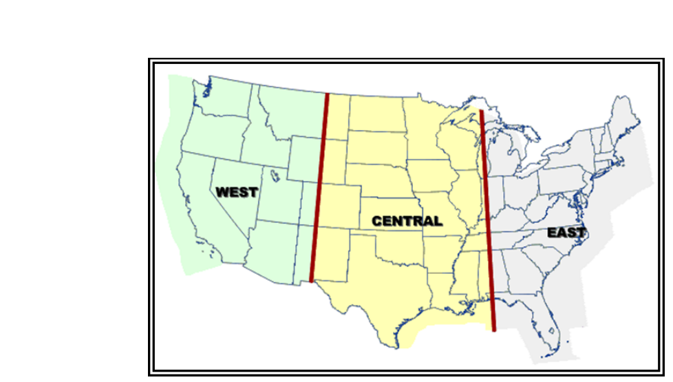
Convective SIGMETs are issued by the Aviation Weather Center (AWC), which is operated by the National Weather Service. The country is divided into three regions for this purpose: the eastern United States (E), central United States (C), and western United States (W). Each region produces its own series of bulletins, so you will see references like "WSUS31 KKCI" in the header of a decoded product, or simply identifiers like "CONVECTIVE SIGMET 14E" on a preflight weather briefing. Knowing the regional breakdown helps you quickly locate the bulletin most relevant to your route.
Issuance Schedule
Convective SIGMETs are issued on a fixed schedule regardless of whether conditions exist. Bulletins go out at 55 minutes past each hour for each region. If no hazardous convective activity is occurring or forecast in a region, the bulletin still transmits — it simply states "NONE" to confirm to pilots and dispatchers that the product was evaluated and no phenomena met the issuance threshold. This scheduled cadence is critical: it means you should expect a fresh update approximately every hour, and a product you pulled at the beginning of a long preflight could already be approaching its expiration by the time you are ready to taxi.
In addition to the scheduled hourly bulletins, Special Convective SIGMETs (also called unscheduled or special issuances) can be issued at any time when a new, rapidly developing hazard arises between the normal 55-minute cycles. These specials carry the same authority and format as a scheduled bulletin and are identified as a SPECIAL in the text. If you are airborne and receive an update from ATC or Flight Watch, it may well be one of these special issuances.
Each Convective SIGMET is valid for a maximum of two hours from the time of issuance, with one important exception: tornado, hail, or wind shear SIGMETs may be issued for shorter intervals if the meteorologist expects the phenomenon to end sooner. For most practical purposes, however, you should treat the two-hour validity window as the standard and always check the expiration time printed in the header before relying on a product.
Issuance Criteria — What Triggers a Convective SIGMET
The AWC meteorologist issues a Convective SIGMET when observed or forecast conditions meet at least one of several defined thresholds. It is essential to understand that these thresholds are specific and objective — a Convective SIGMET is not issued simply because it is raining or because there is some lightning nearby. The following phenomena each individually qualify for issuance:
- Severe thunderstorms: A thunderstorm is considered severe when it contains surface winds gusting to 50 knots or greater, hail at the surface of 3/4 inch (¾ in) in diameter or greater, or tornadoes. Any one of these three conditions alone is sufficient to trigger issuance for a severe thunderstorm.
- Embedded thunderstorms: Thunderstorms hidden within a layer of non-convective cloud (embedded in IFR conditions) are especially dangerous because pilots operating on instruments may inadvertently penetrate them. Even if the storm itself does not meet the severe threshold, being embedded qualifies for a Convective SIGMET.
- A line of thunderstorms: A squall line or organized line of storms at least 60 nautical miles long qualifies, provided thunderstorms affect at least 40 percent of its length. The line criterion captures the hazard of a widespread, organized band that a pilot might try to "pick through," not realizing the continuous nature of the threat.
- An area of thunderstorms: A cluster or area covering at least 3,000 square miles with thunderstorms affecting at least 40 percent of the area qualifies. This threshold recognizes that even if individual cells are scattered, the sheer geographic extent creates an unacceptable penetration risk.
It is worth noting that the Convective SIGMET always describes observed conditions at the time of issuance or forecast conditions anticipated within the valid period. When forecast conditions are the trigger, the bulletin will state clearly that the hazard is expected to develop, giving pilots advance warning even before the activity fully matures.
Geographic Boundaries and Airspace Coverage
Convective SIGMETs apply to all altitudes within contiguous United States (CONUS) airspace. Unlike a standard SIGMET for turbulence or icing, which specifies a flight level range, the convective variety covers from the surface upward without an upper altitude limit. This reflects the nature of convection — a thunderstorm tops can reach 50,000 feet or higher, and no general aviation aircraft ceiling makes an aircraft immune. Alaska and Hawaii receive their own separate Convective SIGMET-equivalent products issued by their respective Weather Service Forecast Offices.
The affected area is described using standard VOR radials, fixes, and geographic references, defining a polygon in plain language. For example, a bulletin might describe the area as "FROM 20 NW OKC TO 40 SW MKC TO 30 SE MCI," creating a triangular area that a pilot can plot on a sectional or low-altitude enroute chart. When a line of storms is the hazard, the bulletin describes the centerline of the line and specifies a width corridor — typically expressed as "10 NM either side" of the line.
Why Convective SIGMETs Matter to Every Pilot
Many student pilots initially treat Convective SIGMETs as something relevant only to instrument-rated commercial pilots flying turbine equipment. This is a dangerous misconception. Thunderstorms generate hazards that can overwhelm any aircraft: extreme updrafts and downdrafts that exceed structural load limits, large hail that can destroy windscreens and engine intakes within seconds, lightning that can cause temporary blindness or avionics failure, and microbursts that produce wind shear capable of causing unrecoverable loss of control during approach or departure. The FAA makes clear in the Aeronautical Information Manual (AIM) and the Aviation Weather Handbook that no aircraft is certified for flight in or through thunderstorms. A Convective SIGMET is therefore a hard stop for penetration, not merely a caution to be weighed against schedule pressure.
Beyond avoidance, Convective SIGMETs affect your flight planning and fuel decisions. If a valid Convective SIGMET lies across your route, you need an alternate routing, added fuel for the detour, and updated weather for the new path — all of which may push your departure time and require a fresh weather briefing cycle.
Key Numbers and Rules
- Issued at 55 minutes past each hour for eastern, central, and western US regions.
- Valid for up to two hours from issuance; check the expiration time on every product.
- Special (unscheduled) issuances can occur at any time between hourly bulletins.
- Severe thunderstorm criteria: surface winds ≥ 50 kt, hail ≥ ¾ inch, or tornado.
- Line of storms: at least 60 NM long, thunderstorms covering at least 40% of the line.
- Area of storms: at least 3,000 square miles, thunderstorms covering at least 40% of the area.
- Applies to all altitudes — no upper limit ceiling applies.
- Covers the contiguous United States (CONUS); separate products exist for Alaska and Hawaii.
- If no hazards exist, the bulletin still transmits with the word "NONE" for each region.
Common Test Traps
- Confusing the issuance time with validity. Convective SIGMETs are issued at 55 past the hour but are valid for up to two hours. Students sometimes assume the next update is at the top of the hour, or that two hours runs from the top of the hour rather than from the actual issuance time. Always check the FROM and UNTIL times in the product header.
- Mixing up the line-of-storms length and area thresholds. The FAA test may present distractors that swap the 60 NM length requirement with the 3,000 square mile area requirement, or change the 40% coverage figure. Memorize both pairs together: 60 NM / 40% for lines, 3,000 sq mi / 40% for areas.
- Assuming a Convective SIGMET has an altitude ceiling. Unlike standard SIGMETs that list a flight level range, Convective SIGMETs cover all altitudes. Do not assume flying at a high altitude above a storm is addressed by a different product — the Convective SIGMET still applies.
- Thinking "NONE" means no product was issued. When conditions do not meet criteria, the scheduled bulletin still transmits with the word NONE. If you cannot find an active Convective SIGMET, verify you are reading a current bulletin, not simply assuming no product exists.
- Overlooking embedded thunderstorm criteria. Students often memorize only the severe storm criteria and forget that a non-severe thunderstorm hidden inside IMC clouds also qualifies. On a cross-country IFR scenario, this is exactly the kind of trap the FAA knowledge test is designed to exploit.