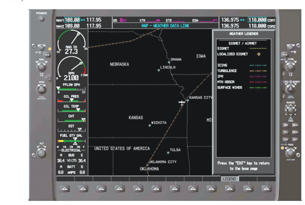
Before every flight, a responsible pilot reviews the available weather products to understand what conditions lie ahead. Among the most critical of these products are SIGMETs (Significant Meteorological Information) and AIRMETs (Airmen's Meteorological Information). Both are official advisories issued by the Aviation Weather Center (AWC) and alerting pilots to hazards that are not already adequately captured in standard forecasts. Understanding the difference between them — which hazards trigger each, which aircraft types they affect, and how long they remain valid — is essential both for passing the FAA Knowledge Test and, more importantly, for making sound go/no-go decisions in the real world.
The fundamental distinction is severity and scope. SIGMETs address phenomena considered hazardous to all aircraft. AIRMETs address conditions that may be hazardous primarily to small aircraft or to pilots with limited experience. Think of a SIGMET as a red alert and an AIRMET as a yellow alert — both deserve your full attention, but they describe very different levels of danger.
What Is a SIGMET?
A SIGMET is an unscheduled advisory issued whenever meteorological conditions are expected to be hazardous to all categories of aircraft — from small single-engine trainers up through heavy transport jets. The National Weather Service (NWS) Aviation Weather Center is responsible for issuing these products. SIGMETs are identified by an alphabetic designator (for example, SIGMET NOVEMBER 3) and carry specific validity periods depending on the type of hazard involved.
There are two subcategories of SIGMETs: non-convective SIGMETs and convective SIGMETs.
Non-Convective SIGMETs
Non-convective SIGMETs cover hazards unrelated to thunderstorm activity. The phenomena that can trigger one include:
- Severe or extreme turbulence not associated with thunderstorms
- Severe icing not associated with thunderstorms
- Widespread dust storms or sandstorms lowering surface visibility below 3 miles
- Volcanic ash — any eruption that injects ash into the airspace
A non-convective SIGMET is valid for up to 4 hours. However, if it is issued for volcanic ash or tropical cyclones, the validity extends to 6 hours. The area covered must be at least 3,000 square miles.
Convective SIGMETs (WST)
Convective SIGMETs are a special category dealing exclusively with convective (thunderstorm-related) activity. They are issued by the AWC and designated with the identifier WST (the old teletype code for Convective SIGMET). These are issued for any of the following conditions:
- Severe thunderstorms with surface winds of 50 knots or greater, hail at the surface of 3/4 inch or greater, or tornadoes
- Embedded thunderstorms
- A line of thunderstorms at least 60 miles long with thunderstorms affecting at least 40% of its length
- An area of thunderstorms covering at least 40% of an area of 3,000 square miles or more
Convective SIGMETs are issued at 55 minutes past each hour, or more frequently as conditions warrant (special convective SIGMETs can be issued at any time). Each is valid for up to 2 hours. The bulletin covers the contiguous 48 states and is divided into three geographic regions: Eastern (E), Central (C), and Western (W). A bulletin with no convective activity to report will read: CONVECTIVE SIGMET... NONE.
What Is an AIRMET?
AIRMETs are scheduled weather advisories aimed at a narrower audience: primarily single-engine and light twin-engine aircraft, VFR pilots, and pilots without instrument ratings. They are issued every 6 hours, with amendments added as needed, and each is valid for 6 hours. The AWC produces AIRMETs for the contiguous U.S. Three distinct types of AIRMETs exist, each designated by a name and a letter code:
- AIRMET Sierra (S) — IFR Conditions and Mountain Obscuration: This advisory warns of ceilings below 1,000 feet and/or visibility below 3 miles affecting at least 50% of an area over 3,000 square miles. It also covers widespread mountain obscuration.
- AIRMET Tango (T) — Turbulence: Issued for moderate turbulence, sustained surface winds of 30 knots or more, or low-level wind shear at altitudes below 2,000 feet AGL.
- AIRMET Zulu (Z) — Icing: Issued for moderate icing and provides freezing level heights. It is worth noting that moderate icing is described as a condition where the rate of accumulation is such that even short encounters become potentially hazardous, and the use of de-icing/anti-icing equipment or flight diversion becomes necessary. Unlike SIGMETs, AIRMETs for icing do not reach the threshold of severe icing.
A practical mnemonic for remembering the three AIRMETs: STZ — Sierra, Tango, Zulu. Picture a salsa club in a time zone: Sierra nights are foggy, Tango is a bumpy dance, and Zulu time is when ice forms on the clock.
Why These Advisories Matter
SIGMETs and AIRMETs fill a critical gap in weather products. METARs report current surface conditions at specific airports. TAFs forecast conditions at specific airports. Area Forecasts (FA) and Prog Charts provide broad regional pictures. But none of these automatically highlight specific corridors or regions where hazardous phenomena are actively observed or expected en route. SIGMETs and AIRMETs do exactly that — they give you location, altitude range, and time window for dangerous phenomena along your route.
Consider a VFR cross-country flight in a Cessna 172. You check the TAFs at your departure and destination airports — both look fine. But an AIRMET Sierra covering your intended route warns of widespread mountain obscuration and ceilings below 1,000 feet in the valleys between. Without checking AIRMETs, you might launch into conditions that rapidly trap you. The advisory exists precisely to prevent that scenario.
For instrument pilots, Convective SIGMETs are equally critical. Even if you hold an instrument rating and your aircraft is certified for IFR, you are never cleared to fly into a thunderstorm. Convective SIGMETs mark territory that demands deviation, delay, or cancellation — full stop.
Key Numbers and Rules
- SIGMET (non-convective): Valid up to 4 hours; 6 hours for volcanic ash or tropical cyclones.
- Convective SIGMET: Valid up to 2 hours; issued at H+55 each hour and as specials any time.
- AIRMET: Valid for 6 hours; issued every 6 hours with amendments as needed.
- Convective SIGMET triggers: Severe thunderstorms with 50+ kt winds, 3/4" hail, or tornadoes; embedded thunderstorms; 60-mile line of storms (40%+ coverage); 3,000 sq mi area of thunderstorms (40%+ coverage).
- AIRMET Sierra triggers: Ceiling below 1,000 ft and/or visibility below 3 miles over 3,000+ sq mi affecting 50%+ of the area.
- AIRMET Tango triggers: Moderate turbulence or sustained surface winds 30+ knots, or low-level wind shear below 2,000 ft AGL.
- AIRMET Zulu triggers: Moderate icing; also provides freezing level data.
- Non-convective SIGMET triggers: Severe/extreme turbulence (not convective), severe icing (not convective), widespread dust/sandstorms below 3 SM visibility, volcanic ash.
Memory Aid
Use STZ to recall the three AIRMET types in order of their common identifier letters:
- S = Sierra → IFR conditions (low ceilings, low visibility) and mountain obscuration
- T = Tango → Turbulence (moderate), strong surface winds, low-level wind shear
- Z = Zulu → icing (moderate) and freezing levels
And remember: SIGMETs = all aircraft; AIRMETs = primarily small/light aircraft. If a condition is bad enough for a SIGMET, it is considered dangerous even for airliners.
Common Test Traps
- Confusing SIGMET icing vs. AIRMET icing: SIGMETs cover severe icing not associated with thunderstorms. AIRMETs cover moderate icing. The FAA test frequently presents both and asks which advisory applies to a described scenario — always focus on the severity word.
- Mixing up validity periods: Students routinely confuse the 4-hour non-convective SIGMET, the 2-hour Convective SIGMET, and the 6-hour AIRMET. Know all three cold.
- Assuming AIRMETs don't apply to instrument pilots: AIRMETs are primarily aimed at light aircraft, but an IFR-rated pilot flying a small plane still faces all the same physical hazards — icing, turbulence, and IFR conditions are dangerous regardless of your rating.
- Convective SIGMET issue time: Test questions sometimes ask when Convective SIGMETs are routinely issued. The answer is 55 minutes past each hour (H+55), not on the hour. Special issues can come at any time.
- Forgetting that "no convective activity" still gets a bulletin: If the AWC finds no conditions warranting a Convective SIGMET, it still broadcasts a bulletin stating "CONVECTIVE SIGMET... NONE" for each region. The absence of a bulletin does not mean no thunderstorm data was checked.