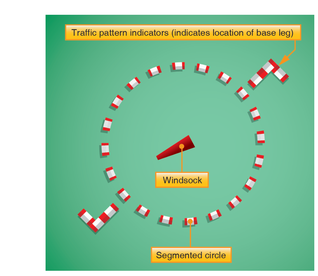
When you approach an uncontrolled airport without a control tower or ATIS, how do you know which runway is active and which direction to fly the traffic pattern? The answer is often painted and mounted right on the airport grounds: the segmented circle system. This standardized visual aid — described in the FAA's Pilot's Handbook of Aeronautical Knowledge (PHAK) — combines several individual indicators into one integrated display that communicates runway use and traffic pattern direction at a glance. Understanding it thoroughly is essential both for the knowledge test and for the real-world safety of operating at the thousands of non-towered airports across the country.
The segmented circle is especially important because pilot self-separation at non-towered airports depends on everyone sharing the same mental model of the active pattern. Misreading the indicators — or ignoring them entirely — can put you on a collision course with another aircraft flying the established traffic pattern. This article breaks down each component of the system, explains how to read them, and flags the exam traps that catch students off guard.
The Segmented Circle: Structure and Purpose
The segmented circle itself is a large circle marked on the airport surface, usually near the wind indicators and typically located at the center of the airport or at a position clearly visible from the traffic pattern altitude. The circle is formed by individual segments (short lines or panels arranged in an arc) with gaps between them — hence the name. This distinctive broken-ring appearance makes it easy to spot from the air and distinguishes it from other markings.
The circle serves as the base structure on which other indicators are mounted or displayed. By itself, the circle says simply: "look here for pattern information." The real information comes from the devices attached to or positioned within it.
The Wind Cone (Windsock)
Typically located at or near the center of the segmented circle, the wind cone (commonly called a windsock) shows the current wind direction and gives an approximate sense of wind speed. The large open end faces into the wind — meaning the sock points into the wind, or upwind — while the small, tapered end trails away, pointing in the direction the wind is blowing toward (downwind). Because aircraft land into the wind, you would select the runway that aligns most closely with the direction the large, open end of the windsock is facing.
Wind speed is estimated by how extended the sock is. A fully extended windsock indicates winds of approximately 15 knots or greater. At lower wind speeds the sock droops, giving a qualitative sense of the intensity. While not a precision instrument, the windsock provides immediately actionable information even before you tune any radio frequency.
Some airports also use a wind tee or a tetrahedron in place of or in addition to a windsock. These devices point into the wind, like an aircraft on approach — in other words, the nose (or point) of the tee or tetrahedron indicates the direction you should land. The tetrahedron in particular can be manually repositioned by airport personnel and may not always reflect actual wind conditions, so it should be used in conjunction with other cues.
Traffic Pattern Indicators (Landing Direction Indicators)
Mounted on the segmented circle itself are the most specific pieces of information: traffic pattern indicators, also called landing direction indicators or pattern direction indicators. These are L-shaped devices (sometimes described as resembling a small hockey stick) positioned at the ends of the segmented circle that correspond to each runway.
Here is how to read them:
- Each L-shaped indicator corresponds to a specific runway. The indicators are positioned around the circle to represent the compass orientation of their respective runways.
- The upright portion of the L indicates the runway direction (final approach course).
- The horizontal arm of the L indicates the direction of the base leg — and therefore tells you which side of the runway the traffic pattern is flown on.
- If the horizontal arm of the L extends to the left of the upright, the pattern is a standard left-hand traffic pattern.
- If the horizontal arm extends to the right, the pattern is a right-hand traffic pattern for that runway.
This distinction is critical. By default, FAA regulations (14 CFR 91.126 and 91.127) require left-hand traffic patterns at airports without an operating control tower, unless otherwise indicated by traffic pattern indicators or a Notice to Air Missions (NOTAM). The L-shaped indicator on the segmented circle is one of the official, FAA-recognized ways to designate a right-hand pattern for a given runway.
When multiple runways exist, you will see multiple L-shaped indicators around the circle, each positioned at the compass point corresponding to its runway. Take care to identify which indicator applies to the runway you intend to use — at a busy multi-runway airport the circle can look complex at first glance, but methodically matching each L to its runway direction clears up the picture.
How to Use the System in Flight
When arriving at an unfamiliar non-towered airport, the standard practice is to overfly the field at a safe altitude (the PHAK and AIM suggest overflying at approximately 500 feet above the traffic pattern altitude, which is itself usually 1,000 feet AGL for piston aircraft) to observe the segmented circle system. From this altitude you can:
- Identify the windsock or wind tee and determine the favored landing direction.
- Locate the segmented circle and its L-shaped indicators for the runway(s) in use.
- Confirm whether a right-hand pattern is designated for that runway.
- Descend to pattern altitude and enter the pattern, typically at a 45-degree angle to the downwind leg.
This overhead observation technique is especially valuable at an airport with no CTAF activity — you are gathering current, visual, on-the-spot information that no sectional chart or NOTAM can fully replace.
Why the Segmented Circle System Matters
Non-towered airports handle a significant proportion of all general aviation operations in the United States. Without a controller to sequence traffic, pilots depend entirely on standardized visual cues and radio self-announcement to maintain separation. The segmented circle system provides a common language that any certificated pilot should be able to read instantly, regardless of what airport they are visiting for the first time.
Failing to check or correctly interpret the segmented circle has real consequences. A pilot who assumes a standard left-hand pattern when a right-hand pattern is designated could fly directly into the path of aircraft flying the correct pattern. This is not a theoretical risk — mid-air collision statistics consistently cite non-towered airport pattern operations as a high-risk environment.
Key Numbers and Rules
- Standard traffic pattern altitude: 1,000 feet AGL for piston-engine aircraft (AIM 4-3-3).
- Default pattern direction: Left-hand turns, per 14 CFR 91.126(b) (Class G) and 91.127(b) (Class E), unless otherwise indicated.
- Windsock full extension: Approximately 15 knots of wind.
- Tetrahedron caution: May be manually set and might not reflect actual wind; always cross-check with the windsock.
- Right-hand pattern authority: Designated by traffic pattern indicators on the segmented circle, by published Airport/Facility Directory (Chart Supplement) information, or by NOTAM.
- Overfly altitude for observation: Approximately 500 feet above TPA (traffic pattern altitude) — commonly 1,500 feet AGL for a 1,000-foot TPA airport.
Memory Aid
For the L-shaped traffic pattern indicator, remember: "The arm shows where base lives." The horizontal arm of the L points in the direction of the base leg. If that arm is on the left side of the upright, base is to the left — left-hand pattern. If the arm is on the right, base is to the right — right-hand pattern. Once you internalize this, reading any combination of indicators around a segmented circle becomes straightforward.
Common Test Traps
- Windsock direction confusion: The open, large end of the windsock faces into the wind (upwind). Many students misread this and select the wrong landing direction. Remember: land toward the large end, which means landing into the direction it faces.
- Tetrahedron vs. windsock: The tetrahedron points like an aircraft — into the wind, indicating the landing direction. The windsock's large end also faces into the wind, but a wind tee also points into the wind (nose into the wind). These all agree in principle but test questions phrase them differently. Know each device's geometry.
- Default left-hand assumption: Students often forget that any runway can be assigned a right-hand pattern. If the segmented circle shows a right-hand indicator, that overrides the default — even if it seems unusual.
- Reading the wrong L: At multi-runway airports, matching the correct L-shaped indicator to the runway in use is essential. Each L is positioned to represent its runway's compass orientation; mismatching them leads to flying the wrong pattern.
- Tetrahedron reliability: The FAA notes that the tetrahedron can be manually repositioned and may not always reflect actual winds. Overreliance on it without cross-checking the windsock is a trap both on the test and in real operations.
Mastering the segmented circle system means you can walk into any non-towered airport situation with confidence. It is a small investment of study time that pays dividends every time you fly into an unfamiliar field — and it is consistently tested on the FAA Private Pilot knowledge exam.