When you're planning a small unmanned aircraft system (sUAS) flight under 14 CFR Part 107, one of the most important preflight tasks is understanding the airspace overhead your intended flight area. The FAA divides airspace into many categories, and a broad group called Special Use Airspace (SUA) deserves particular attention. SUA identifies volumes of airspace where flight activities must be confined, restricted, or at least conducted with extra caution — either because of national security, ongoing military operations, or other hazardous activities taking place in that airspace. For the Remote Pilot Certificate knowledge test and for day-to-day operations, you need to know the three most commonly tested SUA designations: Prohibited Areas, Restricted Areas, and Warning Areas.
Each of these has a distinct legal standing, a specific set of operational rules, and a different level of access for remote pilots. Confusing them is one of the most frequent mistakes on the Part 107 knowledge exam — and in real-world operations, entering one without authorization can carry serious legal and safety consequences. Let's walk through each designation in detail.
Prohibited Areas
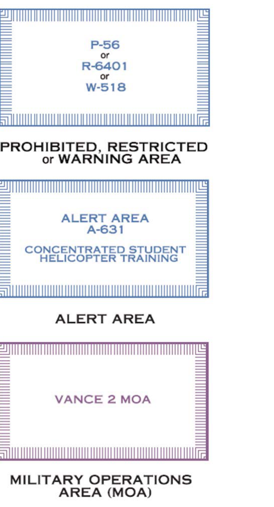
A Prohibited Area is exactly what the name implies: flight within its boundaries is flatly prohibited to all aircraft, including sUAS, at all times. These areas exist to protect locations of extreme national importance — most famously, the airspace over the White House and the United States Capitol. The FAA establishes prohibited areas under 14 CFR Part 73, and they are charted on sectional aeronautical charts with the same blue hashed boundary symbol used for other special use airspace, distinguished by the prefix "P" followed by a number (for example, P-40 over Camp David).
There are no exceptions, waivers, or authorizations available to a remote pilot for flight within a prohibited area. The prohibition is absolute. As a practical matter, these areas are relatively small in number across the National Airspace System, but they are non-negotiable. Before any flight, you must verify your planned route and operating area do not overlap any prohibited area. Tools like the FAA's B4UFLY app, ArcGIS sectional viewer, or LAANC system will flag these boundaries for you, but the ultimate responsibility for compliance rests with the remote pilot in command (RPIC).
Restricted Areas
A Restricted Area is airspace where flight is not prohibited outright but is subject to restrictions because of the existence of unusual, often invisible hazards to aircraft — such as artillery firing, aerial gunnery, guided missile testing, or other military exercises. Restricted areas are also established under 14 CFR Part 73 and are charted on sectional charts with a blue hashed boundary and the prefix "R" (for example, R-2508 over the Edwards Air Force Base complex).
The key distinction from prohibited areas is that restricted areas may be active or inactive depending on scheduled activities, and access for non-participating aircraft — including sUAS — is possible under the right conditions. Each restricted area has a controlling agency (usually a military authority) and a using agency. When the restricted area is not active (i.e., the hazardous activity is not taking place), the controlling agency may release the airspace back to the FAA for normal use, and flight through it may be permitted.
For a Part 107 remote pilot, the procedural implication is important: you may not enter a restricted area without prior authorization from the controlling agency or the FAA, unless that airspace has been officially released and is confirmed inactive. The hours of activity and the altitudes affected are noted both in the Chart Supplement (formerly known as the Airport/Facility Directory) and in relevant NOTAMs. Failing to check both sources is a common mistake. Just because a restricted area is not active every day does not mean it is safe to enter without verification.
Note that restricted areas carry a potential hazard to any aircraft — manned or unmanned — that intrudes without authorization. Ongoing weapons testing, artillery, or other ordnance activity is genuinely life-threatening, which is why the FAA takes unauthorized entry very seriously.
Warning Areas
A Warning Area is similar in character to a restricted area — it contains the same types of hazardous activities, including military training, weapons testing, and high-density flight operations — but with one crucial geographic difference: warning areas extend from 3 nautical miles outward from the U.S. coastline, into international airspace. Because the U.S. cannot legally regulate foreign-flagged aircraft in international airspace the way it can in domestic airspace, the FAA cannot formally prohibit or restrict flight in these areas. Instead, the FAA warns pilots of the potential danger, hence the name.
Warning areas are charted on sectional charts with the same blue hashed boundary style as restricted areas, but with the prefix "W" (for example, W-497 off the coast of Florida). For Part 107 purposes, the practical relevance is that most sUAS operations take place well inland, so warning areas are less frequently encountered. However, coastal drone operations — think aerial photography along a beach or maritime survey work — can bring a remote pilot into close proximity to warning area boundaries.
The FAA strongly cautions all pilots against operating in warning areas, particularly during active military exercises. While the legal framework differs from restricted areas, the physical dangers are identical. As a remote pilot, treating a warning area with the same level of caution and pre-coordination as a restricted area is the conservative and safest approach.
Why It Matters for Remote Pilots
Under Part 107, the remote pilot in command bears direct legal responsibility for every preflight action — including airspace research. Violating a prohibited or restricted area can result in certificate suspension or revocation, civil penalties, and potential criminal liability depending on the severity and circumstances. Unlike manned aviation, where ATC often provides real-time traffic advisories, sUAS operations are largely self-directed. There is no controller calling you on frequency to warn you that you're approaching a restricted boundary. The responsibility is entirely yours.
Additionally, the FAA's LAANC (Low Altitude Authorization and Notification Capability) system, which provides automated airspace authorization for many controlled airspace operations, does not grant authorization to enter prohibited or restricted areas — that is a separate and more complex process, if it is available at all. LAANC is primarily designed for Class B, C, D, and E surface airspace, not for special use airspace.
Key Numbers and Rules
- Prohibited Areas (P-series): Absolute no-fly zones. No authorization available. No exceptions under Part 107.
- Restricted Areas (R-series): Flight not prohibited by default, but requires authorization from the controlling agency when active. Check NOTAMs and Chart Supplement for activity schedules.
- Warning Areas (W-series): Begin 3 nautical miles offshore in international airspace. No formal prohibition applies, but hazards are real — treat with extreme caution.
- Charting: All three are depicted on sectional aeronautical charts using the same blue hashed boundary symbol, distinguished only by the P-, R-, or W- prefix and number.
- LAANC does not authorize SUA entry. Special coordination with the controlling agency is required for restricted areas when active.
- NOTAMs are essential: Restricted area schedules and activations are published via NOTAM. A pre-flight NOTAM check is required under Part 107 before every flight.
- Altitude and time limits: Each restricted or warning area specifies the altitudes affected (surface to a given altitude, or between two altitudes) and the times of use (continuous, intermittent, or by NOTAM).
Common Test Traps
- Confusing Prohibited with Restricted: The exam may offer scenarios where you can "contact the controlling agency" — this applies only to restricted areas, not prohibited areas, where there is no path to authorization.
- Assuming a restricted area is always inactive: The times printed on a chart reflect normal schedules, but the area can be activated outside those times via NOTAM. Always check current NOTAMs, not just the chart.
- Thinking LAANC covers SUA: LAANC grants authorization for certain controlled airspace (Classes B/C/D/E surface), not for prohibited or restricted areas. Many students confuse these systems.
- Warning Area geography: Test questions may ask why the FAA uses the term "warning" rather than "restricted" for coastal military airspace. The answer is that U.S. regulations cannot restrict foreign aircraft in international airspace — so the FAA can only warn, not restrict.
- Ignoring altitude floors: Some restricted areas start above the surface (for example, from 100 feet AGL to FL 180). An sUAS operating below the floor of such an area may technically be legal, but misreading the altitude range is a common and dangerous error on both the exam and in real operations.