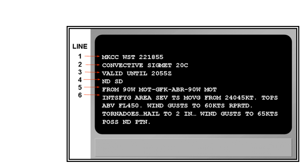
Of all the weather hazards an instrument-rated pilot encounters, convective activity ranks among the most life-threatening. A single mature thunderstorm cell can produce wind shear severe enough to overwhelm aircraft structural limits, hail that destroys windshields and engines in seconds, and turbulence that renders the aircraft uncontrollable. The FAA created the Convective SIGMET specifically to alert pilots — particularly those operating IFR — to convective conditions that demand immediate attention. Understanding exactly what these products say, why they are issued, and how to use them in flight planning and execution is not simply a knowledge-test topic; it is foundational airmanship for every instrument pilot.
This article walks through the structure of the Convective SIGMET product, the unique hazard of thunderstorms embedded within instrument meteorological conditions (IMC), and the practical decision-making and avoidance techniques that keep pilots alive when convective weather is nearby.
What Is a Convective SIGMET?
A SIGMET (Significant Meteorological Information) is an in-flight weather advisory intended for all aircraft. The FAA Aviation Weather Services divides SIGMETs into two broad categories: non-convective SIGMETs (covering phenomena such as severe icing, severe turbulence, and volcanic ash) and Convective SIGMETs, which deal exclusively with thunderstorm-related hazards. Because of the extreme danger involved, Convective SIGMETs receive their own dedicated issuance criteria, format, and urgency level separate from all other advisories.
The Aviation Weather Center (AWC), which issues Convective SIGMETs on behalf of the FAA, divides the contiguous United States into three areas — Eastern (E), Central (C), and Western (W) — and numbers each bulletin sequentially from 01 to 99 each day, restarting at 01 at midnight UTC. This means a valid Convective SIGMET might be labeled MKCC WST 01C for the first Central issuance of the day.
Issuance Criteria: When Do They Get Issued?
A Convective SIGMET is issued for any of the following conditions, as described in FAA weather guidance and the Aviation Weather Handbook (FAA-H-8083-28):
- Severe thunderstorms: Storms producing surface winds of 50 knots or greater, hail at the surface 3/4 inch diameter or larger, or tornadoes.
- Embedded thunderstorms: Thunderstorms obscured within a broader cloud mass — particularly dangerous because pilots may penetrate them without visual warning.
- A line of thunderstorms: A line at least 60 nautical miles long with at least 40% of the line affected by thunderstorm activity.
- An area of thunderstorms: Thunderstorms covering at least 40% of an area of 3,000 square miles or more.
Convective SIGMETs are issued on a scheduled basis every hour at H+55 (55 minutes past each hour) for each of the three regions. However, they are also issued as needed between scheduled times whenever rapidly developing or unexpected severe conditions warrant immediate pilot notification. Each Convective SIGMET is valid for a maximum of two hours from issuance, with tornado-specific bulletins valid for only one hour.
Reading a Convective SIGMET
Every Convective SIGMET follows a standard format: the area identifier, the hazard type, the location (defined by geographic references or latitude/longitude), the movement and speed of the phenomenon, the intensity, and the valid period. A Convective SIGMET might describe a line of thunderstorms moving from 270 degrees at 25 knots, with tops to flight level 430 (43,000 feet MSL), affecting a corridor through the southern Great Plains. Pilots must be able to decode this information rapidly and correlate it with their route of flight.
One critical detail: the advisory describes conditions at the time of issuance and forecasts movement over the valid period. Because convective cells develop, merge, and dissipate unpredictably, a Convective SIGMET should always be considered a floor — actual conditions may be worse. Cross-referencing with real-time weather radar, pilot reports (PIREPs), and METARs is essential.
The Embedded Thunderstorm Hazard
Of all convective scenarios, embedded thunderstorms pose a uniquely insidious threat to IFR pilots. An embedded thunderstorm is one that lies hidden within a large cloud layer — stratiform cloud systems associated with warm fronts, occluded fronts, and areas of widespread precipitation are classic breeding grounds. From the outside, the cloud mass looks like ordinary instrument conditions. There is no visual cue that a violent, mature thunderstorm cell is lurking inside.
An IFR pilot who inadvertently enters an embedded cell may encounter:
- Extreme turbulence: Updrafts and downdrafts can reach 6,000 feet per minute or more in mature cells. These vertical velocities can exceed the structural design limits of most general aviation and many transport-category aircraft.
- Severe icing: The large supercooled water droplets found in convective clouds cause extremely rapid ice accretion, potentially overwhelming even certified anti-icing systems in seconds.
- Wind shear: Both horizontal and vertical wind shear near and within cells can cause sudden, dramatic airspeed changes — leading to stall or structural overload depending on the direction of the shear.
- Precipitation static (P-static): Heavy precipitation can cause radio interference, degrading communications and navigation capability at precisely the moment they are needed most.
- Hail: Hail stones can be ejected from the upper portions of severe cells and travel miles from the visible storm. The FAA guidance notes that hail can exist well beyond the radar returns of a cell.
- Lightning: While direct lightning strikes rarely cause structural failure in modern aircraft, they can damage avionics, temporarily blind pilots, and ignite fuel vapor in rare circumstances.
Why Embedded Thunderstorms Are Especially Dangerous for IFR Pilots
A VFR pilot can often see a thunderstorm and simply fly around it. An IFR pilot in the clouds lacks that option. Without an onboard weather radar or an approved Stormscope/lightning detection system, an IFR pilot relying solely on ATC and published advisories may receive insufficient warning before entering a cell. ATC radar displays precipitation intensity, but controllers are not certified weather forecasters and by regulation cannot provide weather avoidance guarantees — they assist with avoidance to the extent traffic and airspace allow, but the pilot in command is ultimately responsible for avoiding hazardous weather.
Airborne weather radar, when properly operated, is the most effective tool for real-time embedded thunderstorm detection. However, radar requires correct interpretation: the pilot must tilt the antenna to assess storm tops and detect potential hail shafts above the radar beam. A common fatal error is interpreting a radar gap between cells as a safe passage when the gap may actually be a low-reflectivity hail shaft or a region where cells have merged aloft.
Datalink weather products (such as SiriusXM Weather or ADS-B FIS-B weather) present composite radar and Convective SIGMET overlays in the cockpit, but carry a significant time delay — up to 15–20 minutes for some products. This latency means a datalink radar image showing clear air ahead may actually depict conditions that existed 15 minutes ago, during which time a rapidly developing cell could have become severe. Datalink weather is best used for strategic planning and situational awareness, not for threading gaps between cells in real time.
Key Numbers and Rules
- Valid period: Convective SIGMETs are valid for up to two hours; tornado advisories are valid for one hour.
- Scheduled issuance: Every hour at H+55 (55 minutes past the hour) for each region, plus special issuances as needed.
- Areal coverage trigger: 40% or more of an area of at least 3,000 square miles covered by thunderstorms.
- Line trigger: At least 60 NM long with 40% or more of the line active.
- Severe thunderstorm surface wind: 50 knots or more.
- Severe hail threshold: 3/4 inch diameter at the surface.
- Avoidance recommendation: The FAA and aircraft manufacturers generally recommend remaining at least 20 nautical miles laterally from any thunderstorm cell, and more in the presence of severe or extreme activity. Hail can be found well beyond visual and radar returns.
- Tops: Severe thunderstorm tops routinely reach FL400 or above — above the cruise altitude of nearly all piston-powered aircraft and many turboprops. Flight over the top is generally not a viable option in general aviation.
Memory Aid: STOP
When convective weather is encountered or anticipated on an IFR flight, use STOP to structure your decision-making:
- S — Stop and assess: Pause and evaluate all available weather information before proceeding.
- T — Turn: If avoidance is not possible on the current heading, turn to a safe heading rather than pressing into the hazard.
- O — Options: Consider all options — divert, hold, descend below the weather if VMC exists below, or request vectors from ATC.
- P — Priorities: Maintain aircraft control first, navigate second, communicate third — and never sacrifice structural integrity for schedule.
Common Test Traps
- Confusing valid periods: A Convective SIGMET is valid for up to two hours — but tornado advisories are only one hour. Tests commonly mix these up.
- Assuming ATC will keep you safe: ATC provides traffic separation and assistance, but cannot guarantee weather avoidance. The pilot in command bears final responsibility for weather decisions under 14 CFR Part 91.
- Thinking datalink radar is real-time: FIS-B and datalink weather products have a lag of up to 15–20 minutes. Treat them as strategic tools, not tactical guidance for threading convective gaps.
- Ignoring hail beyond the radar return: FAA guidance explicitly warns that hail can extend beyond the visible precipitation return of a cell. Maintaining 20 NM lateral separation from cells helps account for this risk.
- Underestimating embedded thunderstorms: Because embedded cells produce no visible cue, some pilots assume the non-convective SIGMET criteria (e.g., icing or turbulence) adequately describe the risk. Embedded thunderstorms meet Convective SIGMET criteria because the hazard level is categorically different from ordinary IMC turbulence or icing.
Mastering Convective SIGMETs and embedded thunderstorm awareness is not just about passing the instrument knowledge test — it is about building the weather literacy that keeps instrument pilots alive when the forecast fails and the real atmosphere delivers something worse than expected. Treat every Convective SIGMET as a direct, authoritative warning and plan your flight accordingly.