Turbulence is one of the most frequently encountered and potentially dangerous weather phenomena in aviation. According to the FAA Aviation Weather Handbook (FAA-H-8083-28B), Chapter 19, turbulence arises from three primary atmospheric sources: convective currents, obstructions to wind flow (mechanical turbulence), and wind shear. A fourth operationally critical category — wake turbulence — is generated by aircraft themselves rather than the atmosphere, but it produces the same hazardous bumps and rolls that can challenge or overwhelm a crew. Understanding how each type forms, where it is most likely to be found, and how severe it can become is essential knowledge for every pilot from student to ATP.
The FAA classifies turbulence intensity on a four-level scale: light, moderate, severe, and extreme. Light turbulence causes slight, erratic changes in altitude and attitude. Moderate turbulence is similar but of greater intensity, making unsecured objects move about. Severe turbulence causes large, abrupt changes in altitude or attitude and may briefly cause loss of control. Extreme turbulence is violent enough to cause structural damage. Knowing which type of turbulence you are facing helps predict its likely intensity and the best avoidance or escape strategy.
Convective Turbulence
Convective turbulence results from the vertical motions generated by convective currents — the rising and sinking columns of air driven primarily by differential surface heating. When the sun heats the surface unevenly, warm bubbles of air break away and rise through the cooler surrounding air. For every rising current, a compensating downdraft must exist. Importantly, those downdrafts tend to be spread over a broader area than the tighter, faster-rising updraft cores, so they move more slowly but cover more horizontal space.
Convective currents are most vigorous on warm summer afternoons with light surface winds — the textbook recipe for afternoon bumpiness over the plains or desert. Barren, dark, or dry surfaces like rocky soil, asphalt, or plowed fields absorb and re-radiate heat much more efficiently than vegetated ground or open water. This uneven heating creates a patchwork of rising and sinking air cells that can vary dramatically over just a few miles. A pilot flying low over a patchwork landscape on a hot afternoon will feel this as rapid, unpredictable jolts.
As air rises, it cools at the dry adiabatic lapse rate. If it cools to the dewpoint before losing buoyancy, a cumuliform cloud forms, capping the updraft. The cloud top is therefore a useful visual marker for the upper limit of the convective column. Pilots should expect turbulence beneath and within those billowy cumulus clouds; above their tops, air is generally smooth. When convection is strong enough to build towering cumulus (TCU) or cumulonimbus (CB), turbulence intensifies dramatically and can reach extreme levels inside the cloud.
Thunderstorm Turbulence
Thunderstorms represent the most dangerous form of convective turbulence. The FAA states plainly that turbulence is present in all thunderstorms and that severe or extreme turbulence is common. The strongest turbulence within a cumulonimbus occurs at the interfaces between updrafts and downdrafts, where wind shear between adjacent columns is highest. Gust loads can be severe enough to stall an aircraft at maneuvering speed (VA) or cause structural damage at cruise speed.
Hazards extend well beyond the visible cloud. Shear turbulence has been encountered several thousand feet above and up to 20 nautical miles laterally from a severe thunderstorm. Clear-air turbulence (CAT) associated with the anvil cloud — sometimes called Convectively Induced Turbulence (CIT) — can be found 20 or more miles from the anvil edge. The gust front, which is the boundary between the cold outflow and the surrounding warm surface air, can race up to 15 miles ahead of the storm's precipitation and produce an extremely turbulent low-level wind-shear zone. A roll cloud or shelf cloud on the storm's leading edge visually marks this zone. The critical pilot takeaway: never fly through a thunderstorm, and treat the airspace within 20 miles of a severe storm with extreme caution.
A special note on technique: if inadvertently caught in a thunderstorm, the FAA recommends maintaining a constant attitude rather than struggling to hold a constant altitude. Trying to hold altitude by pulling and pushing greatly increases structural stress on the airframe; stress is minimized when the pilot accepts altitude deviations and keeps the wings and pitch as steady as possible.
When the air is too dry for clouds to form, convective currents still exist — these are called thermals or dry convection. Because there are no visible clouds to signal their presence, a pilot has little or no advance warning before encountering the turbulence. Glider pilots deliberately seek thermals for lift; power pilots flying low over desert terrain on a sunny afternoon should expect an invisible bumpy ride.
Mechanical Turbulence
Mechanical turbulence is caused by physical obstructions that disrupt smooth (laminar) airflow and break it into a chaotic tangle of rotating eddies. Obstructions range from trees and buildings at low altitude to mountain ridges at higher altitudes. Any time wind encounters a solid obstacle, it is deflected, separated, and set spinning downstream in irregular vortices. An aircraft flying through these eddies will experience sudden, irregular jolts.
Two factors control mechanical turbulence intensity: wind speed and surface roughness. Higher wind speeds over rougher terrain produce the most intense mechanical turbulence. A 10-knot wind over a flat prairie creates minimal eddies; a 40-knot wind funneling through a mountain pass or over a jagged ridgeline can produce severe to extreme turbulence. The eddies are carried downwind; how far they travel before dissipating depends on both wind speed and atmospheric stability. Unstable air allows larger eddies to form but breaks them up quickly; stable air produces smaller but more persistent eddies that dissipate slowly and can extend far downwind.
Mountain waves are a specialized, large-scale form of mechanical turbulence. When stable air flows over a mountain range, it can set up a train of standing waves extending hundreds of miles downwind and up to the tropopause. Rotors — violently turbulent horizontal vortices — form beneath the wave crests, particularly below the lenticular (lens-shaped) clouds that mark each wave crest. Mountain wave turbulence can be severe to extreme, and the rotor zone near the surface is especially dangerous for low-altitude flight. Lenticular clouds are a visual warning sign that mountain waves are present.
Wind Shear Turbulence
Wind shear is a change in wind speed and/or direction over a short distance — either horizontally or vertically. Wherever two adjacent air masses are moving at significantly different speeds or in different directions, the boundary between them becomes turbulent. The FAA notes that wind shear may occur at any level of the atmosphere and is associated with both wind-speed gradients and wind direction shifts.
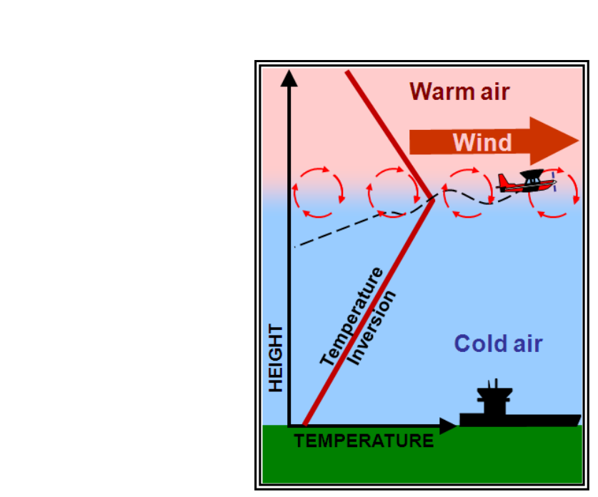
Temperature inversions are a prime low-altitude source of wind shear turbulence. An inversion is a layer where temperature increases with altitude rather than decreasing. Inversions develop from nighttime radiational cooling, along frontal boundaries, or when cold air is trapped in a valley. The calm, stable air below the inversion and the faster-moving air above it create a strong shear zone right at the inversion layer. Pilots descending through this layer on approach may experience sudden airspeed and vertical velocity changes — a particular hazard during takeoff and landing.
Clear-air turbulence (CAT) is defined as sudden severe turbulence occurring in cloudless regions. It is predominantly a high-altitude phenomenon, typically above 15,000 feet MSL, and is most strongly associated with the jet streams. The polar front jet stream and the subtropical jet stream are the two jet streams most relevant to aviation in the contiguous United States. CAT is generated by intense wind shear between the high-speed jet core and the slower-moving air on its poleward flank. CAT is most commonly found on the cold, low-pressure (poleward) side of the jet core, near the tropopause, rather than at any fixed left/right direction, since jet stream orientation varies from flight to flight.
CAT is particularly insidious because it often occurs without any visual clue — no clouds, no precipitation, no visible atmospheric features to warn the pilot. It can appear and disappear abruptly. Common locations to suspect CAT include: near the tropopause on the poleward side of the jet core, near jet stream maxima (areas of locally stronger winds within the jet), at and just upwind of the base of deep upper-level troughs, and in the zone where the polar front jet stream converges with the subtropical jet stream. The wind shear between the two confluent jets can produce highly turbulent conditions immediately downstream of the confluence point.
Wake Turbulence
Wake turbulence is not caused by atmospheric conditions but by the aircraft itself. Whenever a wing generates lift, it creates a pressure differential between its upper and lower surfaces. At each wingtip, high-pressure air from below spills upward around the tip and rolls into a pair of counter-rotating vortices that trail behind the aircraft. These wingtip vortices are the core of wake turbulence. The heaviest aircraft at the slowest speed and highest angle of attack — typically during takeoff and landing — generate the most powerful vortices.
Vortices sink at roughly 300–500 feet per minute and tend to drift with any crosswind component, moving the upwind vortex back toward the runway centerline and the downwind vortex away. They persist for roughly 1–3 minutes in calm conditions and can be encountered several miles behind the generating aircraft. On approach, a following aircraft must maintain proper separation (mandated by ATC wake turbulence separation standards based on aircraft weight categories) and be alert if visual approach spacing is used. Crossing the wake at an upward angle, if possible, keeps the following aircraft above the descending vortex cores.
Key Numbers and Rules
- Thunderstorm lateral hazard: Shear turbulence up to 20 miles laterally; CAT (CIT) 20+ miles from the anvil cloud edge.
- Gust front advance: Can race up to 15 miles ahead of associated precipitation.
- CAT altitude: Typically above 15,000 ft MSL; most common near the tropopause (~30,000–40,000 ft).
- Mechanical turbulence rule: Intensity increases with higher wind speed AND rougher obstructions.
- Thunderstorm technique: Maintain constant attitude, not constant altitude, if caught in a storm.
- Inversion turbulence: Strong wind shear commonly found right at the top of low-level temperature inversions — significant takeoff/landing hazard.
- Vortex sink rate: Wingtip vortices sink approximately 300–500 feet per minute after generation.
Common Test Traps
- Above cumulus = smooth: Students sometimes expect turbulence above a convective cloud top. The FAA states air above cloud tops is generally smooth; turbulence is below and inside the clouds.
- Dry thermals are invisible: When the air is too dry for clouds to form, convective turbulence still exists. No clouds does NOT mean no turbulence.
- CAT is not just near thunderstorms: CAT specifically excludes thunderstorms by definition; it is primarily a jet-stream wind-shear phenomenon. Don't conflate CIT (Convectively Induced Turbulence) with classic CAT.
- Stable vs. unstable eddies: Unstable air creates larger eddies that dissipate quickly; stable air produces smaller but longer-lasting eddies. Students often reverse these.
- Thunderstorm altitude technique: The correct technique is to hold attitude constant, NOT to fight to maintain altitude, when caught in a thunderstorm. Attempting to hold altitude dramatically increases structural stress.