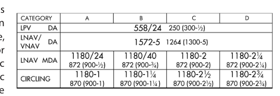
When you pull out an RNAV (GPS) approach plate, you will often see multiple rows of minimums stacked on top of each other: LPV, LNAV/VNAV, LNAV, and sometimes LP or LNAV/VNAV with a circling line. Each row represents a distinct line of minima — a combination of approach category, decision altitude or minimum descent altitude, and visibility requirement. Understanding which line applies to your aircraft and avionics is not just an academic exercise; it determines how low you can legally descend and how much lateral and vertical guidance your equipment is actually providing. The FAA grounds these definitions in AIM Section 1-1-18, which addresses Performance-Based Navigation (PBN) and the WAAS/GPS architecture that makes these approaches possible.
This article breaks down each line of minima — what it requires, how the underlying navigation technology works, and why the differences matter operationally. Mastering this material is essential for the ATP written, the instrument rating practical test, and every actual approach in IMC.
The Foundation: RNAV and RNP
All three lines of minima appear on RNAV (GPS) approach charts, which are predicated on area navigation rather than ground-based navaids. The aircraft computes its position using GPS signals, and WAAS (Wide Area Augmentation System) satellites and ground reference stations can refine that position to sub-meter accuracy. The key concept from AIM 1-1-18 is Required Navigation Performance (RNP) — a statement of the navigation accuracy required to fly the procedure, combined with the aircraft's ability to monitor that accuracy and alert the crew if it degrades. Different lines of minima demand different levels of RNP performance.
LPV: Localizer Performance with Vertical Guidance
LPV stands for Localizer Performance with Vertical Guidance. It is the most precise line of minima on an RNAV (GPS) approach and is enabled by WAAS. LPV approaches use angular lateral and vertical guidance that narrows as the aircraft approaches the runway threshold — identical in concept to a traditional ILS. The lateral full-scale deflection is approximately 350 feet at the runway threshold, and the glidepath is typically 3 degrees, just like an ILS glideslope.
Because LPV provides both lateral and vertical guidance, the pilot uses a Decision Altitude (DA) rather than a Minimum Descent Altitude (MDA). The pilot descends on the glidepath and makes a go/no-go decision at the DA. LPV minimums can be as low as 200 feet HAT (height above touchdown) and 1/2 statute mile visibility — equivalent to a Category I ILS. However, LPV is not an ILS and does not satisfy requirements that specifically call for an ILS unless the operator's operations specifications explicitly permit it.
To fly to LPV minimums, the aircraft must have a WAAS-capable GPS navigator (a TSO-C146 unit or equivalent) and the approach must be loaded from an approved database. The avionics will annunciate LPV in the approach mode display. No baro-altimeter input is required for vertical guidance because the vertical information comes entirely from the WAAS GPS signal.
LNAV/VNAV: Lateral Navigation / Vertical Navigation
LNAV/VNAV stands for Lateral Navigation / Vertical Navigation. Like LPV, it provides both lateral and vertical guidance, so the pilot uses a Decision Altitude (DA). However, the vertical guidance source is different — and that difference produces higher minimums than LPV.
LNAV/VNAV vertical guidance is derived from either of two sources:
- Baro-VNAV: The FMS or GPS navigator computes vertical guidance using barometric altitude. This is the most common source in transport-category aircraft. Baro-VNAV is highly sensitive to altimeter errors, particularly in cold temperatures, and many approaches include temperature restrictions — if the OAT is below a charted temperature limit, baro-VNAV minimums may not be used without cold temperature compensation.
- WAAS LNAV/VNAV: Some WAAS receivers will fly to LNAV/VNAV minimums (rather than LPV) when WAAS vertical accuracy is sufficient for LNAV/VNAV but not quite good enough for the tighter LPV standard. The avionics will annunciate accordingly.
Because baro-VNAV vertical accuracy is not as tight as WAAS-derived LPV guidance, LNAV/VNAV decision altitudes are typically higher than LPV DAs — often by 40 to 100 feet or more. Lateral accuracy is the same RNP 0.3 nautical mile standard used for LNAV, so lateral guidance does not narrow angularly like LPV or an ILS; it remains a constant corridor width.
LNAV: Lateral Navigation Only
LNAV stands for Lateral Navigation. It provides only lateral (horizontal) course guidance — no vertical glidepath. This makes LNAV structurally similar to a traditional VOR or NDB non-precision approach: the pilot descends to a Minimum Descent Altitude (MDA) and must acquire the runway environment before descending below MDA. The crew must level off at the MDA and fly level until either the runway is in sight or the missed approach point is reached.
LNAV uses a Required Navigation Performance of RNP 0.3 NM — meaning the total system error must remain within 0.3 nautical miles of the centerline 95% of the time. Most certified IFR GPS units (even non-WAAS, TSO-C129 receivers) can provide LNAV guidance when a RAIM check confirms sufficient satellite geometry. LNAV minimums are the highest (least favorable) of the three main lines because there is no vertical guidance and the missed approach point may be well before the runway threshold.
The operational technique differs from LPV and LNAV/VNAV. Instead of tracking a glidepath to a DA and then immediately deciding, the pilot levels at MDA, maintains visual scan ahead, and must see the runway environment — runway lights, threshold markings, approach lighting — before descending. The visual descent point (VDP), when charted, indicates where a normal 3-degree descent from MDA would reach the runway touchdown zone, helping avoid a dangerously steep visual segment.
LP: Localizer Performance (a Note)
Some plates also contain an LP line of minima — Localizer Performance — which uses WAAS for angular lateral guidance (narrowing like an LPV) but provides no vertical guidance. LP uses an MDA like LNAV. LP minimums may be lower than LNAV minimums because the tighter lateral accuracy allows a narrower obstacle clearance area. LP is less common but worth recognizing on the plate.
Why It Matters Operationally
The practical hierarchy flows directly from the guidance provided: more guidance = lower minimums = greater access in low visibility. The order from lowest to highest minimums is typically LPV → LNAV/VNAV → LP → LNAV. Modern transport-category aircraft with WAAS FMS will almost always reach LPV or LNAV/VNAV minimums, but understanding the fallback lines is critical when WAAS signal is degraded, a NOTAM downgrades available service, or temperatures affect baro-VNAV.
Importantly, the FAA emphasizes in AIM 1-1-18 that WAAS provides service over a very wide geographic area and that LPV approaches now number in the thousands — more instrument approaches with ILS-equivalent minimums exist via LPV than via traditional ILS. Yet pilots must verify their avionics annunciation; the aircraft, not the chart, determines which line of minima is active.
Key Numbers and Rules
- LPV DA: Can be as low as 200 feet HAT / RVR 2400 (1/2 SM visibility). Requires WAAS GPS (TSO-C146 or equivalent). Vertical guidance is GPS-derived. Uses Decision Altitude.
- LNAV/VNAV DA: Typically 250–400 feet HAT range, though varies by procedure. Requires baro-VNAV or WAAS LNAV/VNAV capability. Check temperature restrictions for baro-VNAV. Uses Decision Altitude.
- LNAV MDA: Highest minimums; no vertical guidance. Requires RNP 0.3 NM (TSO-C129 GPS with RAIM or WAAS). Uses Minimum Descent Altitude. Visual Descent Point may be charted.
- RNP for LNAV and LNAV/VNAV lateral: 0.3 NM total system error within 95% of flight time.
- Baro-VNAV cold temperature limit: Temperature restrictions are published on the approach plate; cold temperatures cause baro altimeters to read high, meaning the aircraft is actually lower than indicated — a significant safety hazard.
- WAAS availability: WAAS is a U.S. FAA system; it does not provide LPV service outside its coverage area. Check NOTAMs for WAAS outages.
Common Test Traps
- DA vs. MDA confusion: LPV and LNAV/VNAV both use a Decision Altitude (DA) because they provide vertical guidance. LNAV uses an MDA because it does not. The exam will test whether you know which type of altitude applies to each line.
- LPV ≠ ILS: LPV provides ILS-like guidance and can have equivalent minimums, but it is NOT an ILS. Operations specs that require an ILS for certain operations are not satisfied by LPV unless explicitly authorized.
- Cold temperature and baro-VNAV: If you are flying LNAV/VNAV using baro-VNAV and the temperature is below the charted limit, you cannot legally use those minimums (or must apply a cold temperature correction). The exam loves this edge case.
- Avionics annunciation determines the line: The aircraft must annunciate LPV (or LNAV/VNAV) for those minimums to be used. If the box annunciates LNAV, you fly LNAV minimums — period — even if LPV is charted.
- RAIM for non-WAAS GPS: Non-WAAS TSO-C129 receivers require a RAIM check before the approach. WAAS receivers provide their own integrity monitoring. Confusing these architectures is a common error.