Introduction
Barometric Vertical Navigation (Baro-VNAV) is a form of approach guidance that constructs a computed vertical flight path using the aircraft's air data system — specifically barometric altitude — rather than a ground-based glideslope transmitter or satellite-based geometric altitude. When a GPS or FMS computes a constant-angle descent path to a runway using baro-altitude as the reference, that system is said to be using Baro-VNAV. The result, displayed as a linear deviation indicator (LDI) or flight path angle cue, gives pilots approach-with-vertical-guidance (APV) capability on many instrument approaches, enabling lower minima than a non-precision approach while avoiding the infrastructure cost of an ILS.
The critical limitation of Baro-VNAV is rooted in basic altimetry physics: a standard altimeter setting corrects for local sea-level barometric pressure, not for non-standard temperature — altimeters do not correct for temperature deviations from the ISA model at all, and that uncorrected error is the entire basis of cold-temperature risk. When the actual atmosphere is colder than the International Standard Atmosphere (ISA), the air is denser than the altimeter model assumes, meaning the aircraft is physically lower than the instrument indicates. On a Baro-VNAV approach, the computer flies you to a pressure altitude that represents the correct geometric altitude only at standard temperature. In cold weather, following the computed path will place the aircraft below the intended geometric profile — potentially into terrain or obstacles. Understanding temperature limits and how corrections are applied is therefore essential for every airline transport pilot who flies RNAV (GPS) or RNP AR approaches using vertical guidance.
How the Vertical Path Is Constructed
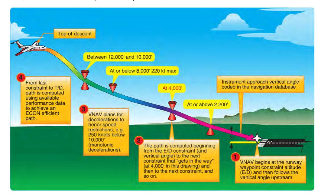
A Baro-VNAV vertical path originates at the final approach fix (FAF) or a path terminator defined by the procedure designer and projects a constant flight path angle (typically 3.00°) to the landing threshold point (LTP) or fictional threshold point (FTP) at a specific height. The FMS or GPS navigator continuously computes the target baro-altitude at each along-track distance from the fix, creating a series of altitude checkpoints the autopilot or flight director follows.
Because this entire path is expressed in pressure altitude units, the underlying assumption is that pressure altitude equals geometric altitude — a condition met only at ISA standard temperature (15°C at sea level, decreasing 2°C per 1,000 feet). When the temperature deviates below standard, the relationship breaks down. A rule of thumb widely used in instrument flight is that for every 1°C below ISA, the altimeter over-reads by approximately 4 feet per 1,000 feet of height above the altimeter setting source. At an airport elevation of 5,000 feet MSL on a day that is 20°C below ISA, this error compounds to roughly 400 feet — the aircraft could be 400 feet below the computed path in geometric terms while the altimeter reads exactly on the path altitude.
VNAV Path Angle and Threshold Crossing Height
The procedure designer selects a flight path angle (FPA) — most commonly 3.00° but sometimes steeper for terrain avoidance — so that the threshold crossing height (TCH) and all intermediate altitudes provide the required obstacle clearance surface (OCS). That OCS is evaluated geometrically. When cold temperature compresses the actual altitude below the baro-indicated altitude, the aircraft pierces the OCS even while following the computed VNAV path perfectly. This is why approach charts publish either a temperature limit below which Baro-VNAV may not be used, or a table of baro-altitude corrections the pilot must add to all segment altitudes.
AC 90-105A: The Regulatory and Advisory Framework
Advisory Circular 90-105A, Approval Guidance for RNP Operations and Barometric Vertical Navigation in the U.S. National Airspace System and in Oceanic and Remote Continental Airspace, is the primary FAA document governing Baro-VNAV operations. It establishes the airworthiness criteria, operational approval requirements, and temperature compensation standards that operators must follow.
AC 90-105A defines two methods for managing cold-temperature error on Baro-VNAV approaches:
- Temperature limit method: The approach chart publishes a minimum airport temperature (for example, −15°C). If the reported temperature at the airport is at or below that limit, Baro-VNAV vertical guidance is not authorized and the pilot must fly the approach using LNAV minima (lateral navigation only, treating the procedure as non-precision).
- Cold temperature compensation (CTC): Certain aircraft FMS units include an approved automatic cold temperature compensation function that adjusts the computed baro-VNAV path to account for the difference between actual and standard temperature. When the avionics are so approved and the function is active, Baro-VNAV may be used below the published temperature limit without manual pilot corrections. Operators must verify that their OpSpec or LOA explicitly authorizes CTC and that it is enabled for the approach.
AC 90-105A also addresses the requirement for pilots to apply manual altitude corrections to intermediate and missed approach segment altitudes at airports where cold temperature corrections are required by chart note, even when using LNAV-only minima. The ICAO cold-temperature correction tables (commonly used worldwide) or FAA-published correction tables must be used, and ATC must be informed when non-standard altitudes are being flown so that separation is not compromised.
Why It Matters: Safety and Obstacle Clearance
The consequences of ignoring temperature limits are not theoretical. Cold weather operations at mountainous or high-elevation airports present genuine CFIT (controlled flight into terrain) risk. A crew flying a Baro-VNAV path on a night approach to a 6,000-foot airport when the temperature is −30°C could be 500 feet or more below the intended geometric path at the FAF. Tall terrain features or communication towers that the procedure designer cleared by 300 feet geometrically would have their clearance eliminated.
The missed approach is equally critical. Minimum descent altitudes and missed approach waypoint crossing altitudes specified on the plate are barometric values. In severe cold, the aircraft may reach the minimum baro-altitude and begin climbing while still physically lower than the design geometry requires. For this reason, AC 90-105A requires cold-temperature altitude corrections on the missed approach segment as well, and many approach charts now carry explicit notes instructing pilots to apply ICAO Doc 9905 corrections to intermediate, final, and missed-approach fix altitudes when operating below a specified temperature.
Key Numbers and Rules
- Standard lapse rate assumed by baro-VNAV: ISA — 15°C at MSL, −2°C/1,000 ft.
- Typical temperature limit on U.S. Baro-VNAV approaches: commonly −15°C to −20°C; the specific value is chart-dependent and must be read from the approach plate notes.
- Approximate error magnitude: roughly 4 ft of under-read per 1,000 ft of height AGL per 1°C below ISA — a useful mental check, not a certified correction formula.
- Correction method authority: ICAO cold-temperature correction tables or the FAA equivalent, applied to all affected altitude segments.
- ATC notification: Required when flying non-published (corrected) altitudes; phrase: "Unable [procedure] due cold temperature, request [corrected altitude or alternate routing]."
- OpSpec/LOA requirement: Part 121 and 135 operators must hold appropriate operations specifications (OpSpec B034 for RNP AR, or applicable authorization) to fly Baro-VNAV approaches; Part 91 operators must meet the equipment and training standards in AC 90-105A.
- FMS CTC activation: Even when the avionics are capable, the pilot must confirm CTC is active before commencing an approach below the published temperature limit — it is not always enabled by default.
Memory Aid: "COLD PATH FALLS"
Remember: Cold air = Over-read altimeter = Lower actual altitude = Danger. The PATH the computer flies is too low geometrically; the aircraft FALLS short of obstacle clearance. When temperatures drop, either stay above the limit, apply corrections, or revert to LNAV. This mnemonic is an instructor teaching device; the authoritative check remains AC 90-105A and the approach plate notes.
Common Test Traps
- Confusing direction of error: Cold temperatures make the altimeter over-read, meaning the aircraft is lower than indicated — not higher. Students frequently reverse this, believing cold air makes you think you are lower than you are.
- Assuming CTC is always active: An FMS equipped with cold-temperature compensation does not automatically apply it. The pilot must verify the function is enabled and that operational authorization exists. Selecting VNAV on the mode control panel does not confirm CTC is running.
- Ignoring the missed approach segment: Many candidates know to correct final approach altitudes but forget that missed approach altitudes are equally affected by cold temperature and must also be corrected or avoided.
- Misidentifying when to revert to LNAV: The temperature limit on the chart applies to the use of Baro-VNAV (LPV or LNAV/VNAV minima); it does not prohibit flying the approach at all. The pilot reverts to LNAV minima (higher MDA) when below the temperature limit without CTC.
- Overlooking ATC coordination: When applying cold-temperature corrections, the pilot will be flying altitudes not published on any chart. Failing to notify ATC is both an operational error and a regulatory issue, as it disrupts IFR separation standards.