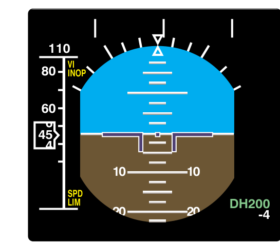
When flying a precision or precision-like instrument approach, the published minimum descent point is not a suggestion—it is a hard decision point. The pilot must determine, at that exact moment, whether the runway environment is in sight and whether a safe landing can be made. Miss that moment and continue descending blindly, and the outcome can be fatal. Two closely related terms define this critical point: Decision Altitude (DA) and Decision Height (DH). Though they refer to the same operational concept, the way each is measured—and the equipment required to use each—are fundamentally different, and confusing the two is one of the most common ATP written exam errors.
This article explains what DA and DH mean, how they are measured, when each applies, and why the radio altimeter is not merely a convenience but a safety-critical requirement for certain approaches. A thorough understanding of these concepts is mandatory for any pilot operating under instrument flight rules, and especially for those pursuing an Airline Transport Pilot certificate.
Defining Decision Altitude and Decision Height
Decision Altitude (DA) is referenced to mean sea level (MSL). It is expressed as an MSL elevation—just like any other altitude in the altimeter system—and the pilot monitors it using the barometric altimeter. When the altimeter winds down to the published DA value, the pilot must initiate a missed approach unless the required visual references are clearly in sight and the aircraft is in a position from which a normal landing can be made.
Decision Height (DH), by contrast, is referenced to the threshold elevation of the runway, making it a height above ground level (AGL) at the runway threshold. Because DH is an AGL measurement, it cannot be reliably indicated by a barometric altimeter, which measures pressure altitude corrected to MSL. Instead, DH is monitored using a radio altimeter (also called a radar altimeter), which continuously measures the actual geometric distance between the aircraft and the terrain or surface directly below. The pilot watches the radio altimeter's readout and, when it counts down to the published DH value, makes the land-or-go-missed decision.
How Each Applies: Approach Categories
The distinction between DA and DH tracks directly with the type of approach being flown.
- ILS (Instrument Landing System) approaches to Category I minimums — These use a DA, referenced to MSL, monitored on the barometric altimeter. A typical Cat I DA is 200 feet above the touchdown zone elevation, which translates to a specific MSL altitude published on the approach plate. No radio altimeter is required for Cat I operations by regulations, though many airlines mandate its use.
- ILS approaches to Category II and Category III minimums — These use a DH, referenced to threshold elevation and monitored on the radio altimeter. A Cat II DH is typically 100 feet above the touchdown zone elevation; Cat IIIa may have a DH as low as 50 feet; Cat IIIb may have a DH of less than 50 feet or, in some authorizations, no DH at all. The radio altimeter is a required system for Cat II and III operations.
- RNAV (GPS) and LPV approaches — Those with vertical guidance down to 200 feet use a DA, just like an ILS Cat I. The barometric altimeter is the primary reference. The approach plate will show the DA as an MSL altitude with the equivalent AGL height noted in parentheses for situational awareness.
- GLS (GBAS Landing System) approaches — These may use either DA or DH depending on the category of operation and the specific authorization.
The Radio Altimeter: How It Works and Why It Matters
A radio altimeter transmits a continuous radio frequency signal (typically in the 4.2–4.4 GHz band) straight down toward the surface. The unit precisely measures the time it takes for that signal to reflect off the ground and return to the aircraft's receiver. Because the speed of electromagnetic radiation is constant, the round-trip travel time directly and accurately yields the geometric altitude above the surface—not above sea level, not corrected for temperature, but the true vertical distance to whatever is below the aircraft at that moment.
This matters enormously in the approach environment. As an aircraft descends on the ILS glideslope, it passes over terrain that may vary in elevation before reaching the flat, paved surface of the runway threshold. The radio altimeter reads actual height above that varying terrain in real time. For Cat II and Cat III approaches, where decision heights can be 100 feet or less, the barometric altimeter simply does not have sufficient resolution or accuracy—temperature errors, altimeter setting errors, and instrument tolerances can collectively introduce errors of tens of feet. A 50-foot DH approached with a barometric altimeter carrying a 30-foot cold-temperature error is a recipe for controlled flight into terrain.
The radio altimeter also provides crucial inputs to other avionics. Ground Proximity Warning Systems (GPWS) and Enhanced GPWS (EGPWS) rely on radio altimeter data to trigger timely alerts. Autoflight systems on transport-category aircraft use the radio altimeter to initiate the flare during autoland sequences. In Category IIIb autoland operations, the radio altimeter effectively replaces the pilot's eyes for determining proximity to the runway surface.
Key Numbers and Rules
- Cat I ILS: DA at or above 200 feet AGL (published as an MSL DA); RVR 2,400 feet (or 1,800 feet with certain equipment). Radio altimeter not required by regulation for the approach, but required for many airline ops specs.
- Cat II ILS: DH between 100 feet and less than 200 feet above the touchdown zone elevation; RVR as low as 1,200 feet, and as low as 1,000 feet depending on the specific approach authorization. Radio altimeter required. Pilots must be specifically authorized for Cat II operations.
- Cat IIIa ILS: DH less than 100 feet (commonly 50 feet); RVR not less than 700 feet. Radio altimeter required.
- Cat IIIb ILS: DH less than 50 feet, or no DH; RVR less than 700 feet down to 150 feet. Full autoland with radio altimeter required.
- DA vs. DH nomenclature on plates: Approach plates will show DA(H) for precision approaches, with the MSL value first and the AGL height in parentheses. The letter in parentheses distinguishes DA from DH at a glance—if the approach requires a radio altimeter for the minimums, the plate notes DH; otherwise, it is DA.
- Temperature correction: DA is subject to cold-temperature altitude errors because it is barometric. On very cold days, the aircraft may be significantly lower than the altimeter indicates at the DA. Pilots should apply cold-temperature corrections per the AIM or use airport-published cold temperature restricted airports (CTRAs) procedures. DH measured by radio altimeter is not subject to temperature error.
- Required visual references: At DA or DH, the pilot must have the runway environment in sight—runway lights, threshold, touchdown zone, or other specified visual references—and be in a position to execute a normal landing. If not, a missed approach must be initiated immediately.
Why It Matters Operationally
The practical consequence of confusing DA and DH can go beyond a wrong answer on a written test. If a crew flying a Cat II approach monitors their barometric altimeter for a DH that should be referenced to the radio altimeter, they may initiate the missed approach at the wrong point—too early, wasting a legitimate approach opportunity in marginal weather, or too late, continuing below decision height without the required visual references. Airlines address this through crew training, standard callout procedures, and avionics that automatically annunciate when the radio altimeter passes through the pre-selected DH.
For general aviation pilots transitioning to turbine equipment and pursuing ATP certificates, the key takeaway is that the type of altimeter being used defines the term. Barometric = DA (MSL reference). Radio altimeter = DH (AGL reference). The moment the approach category requires a radio altimeter, the terminology and the reference point change.
Common Test Traps
- Confusing MSL vs. AGL reference: Exam questions often provide both values and ask which instrument monitors each. Remember: DA uses the barometric altimeter (MSL), DH uses the radio altimeter (AGL).
- Assuming Cat I requires a radio altimeter: 14 CFR Part 91 does not require a radio altimeter for a standard Cat I ILS approach. Many airline ops specs do, but the regulation itself does not. Know the distinction.
- Thinking DH can be zero: Cat IIIb authorizations can indeed specify no DH (zero-zero approaches in some autoland authorizations), which surprises many students. The radio altimeter still operates, but the limiting factor becomes RVR, not DH.
- Applying temperature corrections to DH: Cold-temperature corrections apply to barometric altimeter readings—meaning DA. They do not apply to radio altimeter–based DH, because the radio altimeter is a direct geometric measurement unaffected by atmospheric temperature.
- Missing the action requirement: DA/DH is the point where the decision must be initiated, not completed. The missed approach procedure begins at DA/DH, not after the pilot spends another few seconds deciding. Examiners test whether candidates understand that any continued descent below DA/DH without required visual references is non-compliant.