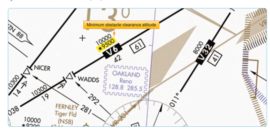
When flying IFR along a published airway, two altitude values appear on your enroute chart that look similar but serve very different purposes: the Minimum Enroute Altitude (MEA) and the Minimum Obstruction Clearance Altitude (MOCA). Both protect you from hitting terrain and obstacles, but only one guarantees that your navigation radio will reliably receive the ground-based navaid defining the airway. Confusing the two—or not understanding when you can legally use one versus the other—is a classic instrument rating trap that can bite you both on the knowledge test and in actual IMC.
This article breaks down exactly what each altitude provides, the regulatory and operational differences between them, and the situations where a pilot might legitimately fly at MOCA rather than MEA. Mastering this distinction is fundamental to safe IFR enroute operations and a staple of FAA written-exam questions.
What Is the Minimum Enroute Altitude (MEA)?
The MEA is the lowest published altitude between two fixes on an airway that simultaneously satisfies two independent requirements. First, it provides the required obstacle clearance: in non-mountainous areas, the MEA guarantees at least 1,000 feet of clearance above the highest obstacle within the protected airway width. In designated mountainous areas, that buffer increases to 2,000 feet. Second—and this is what distinguishes the MEA from MOCA—it ensures acceptable navigation signal coverage from the VOR, VORTAC, or other navaid that defines the route segment.
On a standard IFR enroute low-altitude chart (the L-series), the MEA is printed in large bold numbers above the airway centerline. For example, you might see "8000" on a segment, meaning you must fly at or above 8,000 feet MSL to comply with MEA requirements. If ATC assigns you an altitude at or above MEA, you can assume both obstacle clearance and navaid reception are guaranteed for that segment.
The FAA establishes MEAs through a careful analysis of terrain, obstruction data, and signal coverage testing of the navaid involved. Because VOR signals follow line-of-sight principles—they do not bend around mountains—the altitude required to receive a reliable signal can sometimes be considerably higher than what terrain alone would dictate. This is why two otherwise similar-looking airway segments can have dramatically different MEAs.
What Is the Minimum Obstruction Clearance Altitude (MOCA)?
The MOCA, printed on the chart with a leading asterisk (for example, *6200), is the lowest altitude on a route segment that provides the required obstacle clearance—1,000 feet in non-mountainous terrain, 2,000 feet in mountainous terrain—but does not guarantee usable VOR reception along the entire segment. The MOCA only guarantees VOR navigation signal reception within 22 nautical miles of the VOR that defines the route.
This distinction has a very direct practical implication. If you are flying a 90-nautical-mile airway segment at MOCA, you will have acceptable VOR signal strength only when you are within 22 nm of the station at either end of the segment. In the middle of that segment, your CDI needle may wander, the OFF flag may appear, or the signal may become unreliable—and at MOCA, that is perfectly legal by design. You are essentially accepting the trade-off of lower terrain clearance altitude in exchange for potentially degraded navaid coverage for portions of the route.
The 22 nm figure comes from FAA signal coverage standards. Below MEA, the FAA only certifies that a VOR can reliably provide navigation guidance within that radius from the station. Beyond 22 nm from the VOR, the signal may be too weak or too distorted by terrain to be usable at the lower MOCA altitude.
When Can You Fly at MOCA Instead of MEA?
Under 14 CFR Part 91.177, a pilot operating IFR on a Federal airway must fly at or above the MEA. However, 91.177(a)(2) provides a specific exception: on a route segment where a MOCA is published, a pilot may operate below the MEA — but not below the MOCA for that segment — while within 22 nautical miles of the VOR from which the MOCA is designated. This is not a general-purpose option available on any segment; it applies only where a MOCA has actually been published for that route and only within the 22 NM radius of the defining VOR. ATC may also assign an altitude at or above MOCA when a lower altitude is necessary for operational reasons, provided the controller is satisfied with separation and the pilot is close enough to the navaid for signal reception.
In practice, this provision is most useful in areas of rapidly changing terrain—perhaps beginning a descent earlier than the MEA would normally permit—as long as a MOCA is published for that segment and you remain within 22 nm of the defining VOR. It is worth emphasizing: flying at MOCA is not a shortcut to save time or fuel. It is a legitimate, carefully designed operational option, but it narrows your margin and should be exercised with clear situational awareness.
How MEA and MOCA Appear on Charts
On the FAA's IFR Enroute Low Altitude charts, the visual presentation makes the distinction quick to identify once you know the code:
- MEA — printed as a plain number above or near the airway centerline, e.g., 6000. This is the altitude you plan to fly as your minimum under normal circumstances.
- MOCA — printed with a leading asterisk, e.g., *5200. The asterisk is your visual reminder that obstacle clearance only is guaranteed at this altitude.
- When both altitudes are published for a segment, you may see them stacked or side by side, such as 6000 / *5200, with the MEA on top.
- A Maximum Authorized Altitude (MAA) may also appear on some segments, setting an upper bound where signal interference from multiple navaids becomes a concern—don't confuse it with MEA or MOCA.
The Role of GNSS and Modern Navigation
With GPS-based RNAV increasingly common in the IFR environment, it is worth noting that MEAs established for GPS or RNAV routes focus primarily on obstacle clearance, since GPS satellites are not terrain-constrained the way ground-based VORs are. However, on conventional VOR airways, the MEA/MOCA distinction remains fully applicable, and the FAA knowledge test absolutely tests it in the context of traditional ground-based navigation. Even if your aircraft is GPS-equipped, understanding the VOR-based MEA/MOCA framework is essential for reading enroute charts and for flying in environments where RNAV routes are not available.
Why This Distinction Matters for Safety
The reason both altitudes exist is rooted in a fundamental tension: sometimes the altitude needed for reliable VOR reception is higher than the altitude needed to clear obstacles. Requiring pilots to always fly at MEA would provide consistent navigation, but could also force unnecessarily high altitudes in some segments. Publishing both values gives pilots—and ATC—flexibility while clearly communicating the trade-offs involved.
The safety risk of misunderstanding this distinction is real. A pilot who descends to MOCA when more than 22 nm from the VOR may find their navigation unreliable precisely in the area where terrain is already closer than usual. In mountainous terrain with 2,000-foot obstacle clearance requirements, even a small navigational deviation from centerline at MOCA could reduce terrain separation significantly. Understanding why the MEA exists—not just that it is a number on a chart—leads to better aeronautical decision-making.
Key Numbers and Rules
- MEA obstacle clearance: 1,000 ft in non-mountainous areas; 2,000 ft in designated mountainous areas.
- MOCA obstacle clearance: Same as MEA — 1,000 ft / 2,000 ft — but navaid reception only guaranteed within 22 nm of the VOR.
- VOR reception at MOCA: Guaranteed only within 22 nautical miles of the defining VOR.
- Regulatory reference: 14 CFR §91.177 governs minimum altitudes for IFR operations, including MEA requirements; §91.177(a)(2) specifically permits descent to a published MOCA within 22 NM of the defining VOR.
- Chart symbol: MOCA is always preceded by an asterisk (*) on enroute charts.
- When MOCA is usable: Only on a segment where a MOCA is actually published, when you are within 22 nm of the VOR, and either operating under ATC clearance at that altitude or the regulations explicitly permit it.
Memory Aid
A proven way to keep MEA and MOCA straight is the phrase: "MEA = Everything Assured; MOCA = Obstacles Cleared Always (navaid only close)." More specifically, remember the asterisk on MOCA as a warning star — it signals a limitation. And for the 22-mile rule: think of "MOCA = 22", because 22 nm from the VOR is the boundary of guaranteed signal reception when flying at the lower altitude. MEA gives you the full package; MOCA gives you the floor only.
Common Test Traps
- Assuming MOCA provides full navaid coverage: The most common mistake. MOCA only guarantees VOR reception within 22 nm of the station — not along the entire segment.
- Forgetting the asterisk symbol: On the knowledge test, MOCA is always shown with an asterisk (*). If you see a plain number, it is the MEA. Misreading the symbol leads to wrong answers about which altitude applies.
- Misapplying the 22 nm rule: Some students think 22 nm applies to MEA as well. It does not. The 22 nm limitation is exclusive to MOCA signal coverage.
- Confusing mountainous vs. non-mountainous obstacle clearance: The obstacle clearance standard changes from 1,000 to 2,000 feet in designated mountainous areas. FAA questions sometimes specify terrain type to test whether you know the correct buffer.
- Thinking MOCA is always lower than MEA: On many segments MOCA and MEA are the same value — the navaid signal coverage happens to be adequate at the obstacle clearance altitude. In those cases, only the MEA is published, because there is no operational difference to communicate.