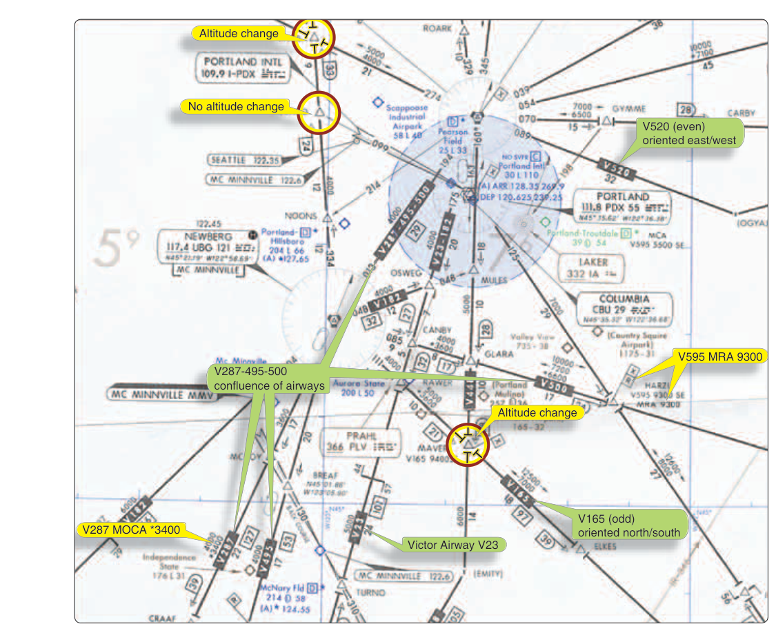
When you earn your instrument rating, you gain access to the airway system — a structured network of invisible highways crisscrossing the country at various altitudes. Among the most fundamental of these are Victor airways, the backbone of low-altitude IFR navigation in the United States. Understanding how Victor airways are constructed, what altitudes apply, and why those numbers matter is essential both for passing your instrument knowledge test and for planning safe, legal IFR flights in the real world.
Victor airways exist so that IFR pilots can navigate predictably between VOR stations along pre-defined routes that have been carefully evaluated for obstacle clearance and radio reception. When you file a flight plan along a Victor airway, you are operating within a published, regulated structure — not just pointing at a waypoint and hoping for the best.
How Victor Airways Are Constructed
Victor airways, also called VOR Federal Airways, are defined by courses drawn directly between VOR (VHF Omnidirectional Range) stations or between a VOR and a named intersection. Each airway is identified by the letter V followed by a number — for example, V23 or V105. These designations appear on IFR Enroute Low Altitude charts (commonly called "Lo" charts), which are the primary chart product for low-altitude IFR navigation.
Each Victor airway is 8 nautical miles wide — 4 nautical miles on each side of the centerline. This width is not arbitrary; it accounts for the aircraft's ability to track the VOR radial accurately at the distances involved and provides a lateral buffer against terrain and obstacles near the route.
Victor airways exist in the low-altitude enroute structure, which spans from 1,200 feet AGL up to but not including 18,000 feet MSL. Above 18,000 feet MSL, you enter Class A airspace, where Jet Routes (the "J" routes) and eventually RNAV routes take over. Victor airways are therefore the tool of choice for most piston-powered general aviation aircraft flying IFR cross-countries.
Minimum Enroute Altitude (MEA)
Every segment of a Victor airway has a published Minimum Enroute Altitude (MEA). The MEA is arguably the most important number associated with any airway segment, and it serves two simultaneous guarantees:
- Obstacle clearance: The MEA ensures at least 1,000 feet of clearance above all obstacles within the airway's protected area in non-mountainous terrain, and at least 2,000 feet of clearance in designated mountainous areas.
- Navigation signal reception: At or above the MEA, you are guaranteed to receive an adequate VOR signal from the defining navaid(s) for the route segment. This is a critical point — the MEA is not just about rocks; it's about being able to actually navigate the airway.
MEAs are shown on the Lo chart in bold alongside each airway segment, between the two fixes that define that segment. When you fly IFR on a Victor airway, flying at or above the MEA is a legal requirement under IFR, not just a suggestion. ATC may assign you an altitude at or above the MEA, but they cannot legally assign you below it while you are flying that segment — and if an off-route altitude would place you below the MEA for a segment you will cross, that's a problem to catch during planning.
Other Published Altitudes on Lo Charts
Victor airways frequently show additional altitude values beyond the MEA, and students often confuse them on test day. Understanding each one is critical.
Minimum Obstruction Clearance Altitude (MOCA)
The MOCA guarantees obstacle clearance (the same 1,000/2,000 feet buffers as the MEA), but only guarantees VOR signal reception within 22 nautical miles of the VOR. Beyond 22 nm, signal reception at the MOCA is not assured. On the chart, a MOCA is shown with an asterisk preceding the altitude value (e.g., *3400). If ATC clears you to an altitude at or above the MOCA but below the MEA, you must be within 22 nm of the VOR to rely on that navaid for navigation. In practice, the MOCA is useful in emergencies or for temporary descent when the aircraft needs lower altitude for pressurization or weather avoidance, but only close to the VOR.
Minimum Reception Altitude (MRA)
An MRA applies at specific intersections along an airway. It is the lowest altitude at which an aircraft can receive the off-course VOR or DME signals needed to identify that particular intersection. MRAs are shown on Lo charts with the letters "MRA" and the altitude value near the intersection. If you are below the MRA for an intersection, you cannot reliably identify that fix, which matters for step-down approaches, holds, or reporting points.
Maximum Authorized Altitude (MAA)
Some airway segments have a published MAA, which is the highest altitude at which you may fly that airway segment and still receive reliable navigation signal. Flying above the MAA can cause signal interference from more distant VOR stations on the same frequency. MAAs are not extremely common on Lo charts but are worth recognizing when they appear.
Minimum Crossing Altitude (MCA)
An MCA applies when a higher MEA begins on the next segment of an airway and terrain or signal requirements mean the aircraft must already be at that next segment's MEA before crossing the fix — not after. An MCA is shown with a flag symbol and the letters "MCA" near the fix. If you are cruising at a lower MEA and approaching a fix where the next segment has a significantly higher MEA, you need to begin climbing early enough to cross the fix at or above the MCA.
Why Victor Airways and MEAs Matter
The practical safety value of MEAs is immense. Imagine flying through mountainous terrain in IMC — zero visibility, no visual reference to terrain whatsoever. The MEA is your guarantee that the terrain below you is at a known, safe distance. Deviating below the MEA without ATC authorization in IMC is one of the most dangerous things a pilot can do, akin to gambling with controlled flight into terrain (CFIT), which remains one of the leading causes of fatal aviation accidents.
MEAs also ensure that you can navigate. In a single-pilot IFR environment, losing reliable VOR reception partway through a segment can be disorienting and potentially dangerous. The MEA takes away that guesswork — if you're at or above it, the system works as published.
From a flight planning perspective, MEAs on individual segments may vary considerably along a route. A cross-country flight through mountainous terrain may require substantially higher cruising altitudes than flat midwest terrain just to meet MEAs on each individual segment. Always review each segment's MEA during preflight planning, not just the overall route.
Key Numbers and Rules
- Airway width: 8 nautical miles total (4 nm each side of centerline).
- Victor airway altitude range: 1,200 feet AGL up to but not including 18,000 feet MSL.
- MEA obstacle clearance (non-mountainous): 1,000 feet above all obstacles in the protected area.
- MEA obstacle clearance (mountainous): 2,000 feet above all obstacles in the protected area.
- MOCA VOR reception guarantee: within 22 nautical miles of the VOR only.
- MOCA on chart: preceded by an asterisk (*) before the altitude value.
- MCA purpose: ensures aircraft has climbed to the next segment's MEA before crossing the fix.
- Airway identifier format: letter V followed by a number (e.g., V23, V105).
Memory Aid
To remember the key difference between MEA and MOCA, use this phrase: "MEA = Everything Assured; MOCA = Only Close (22 nm)." The MEA guarantees both obstacle clearance AND full VOR reception across the entire segment. The MOCA only guarantees obstacle clearance and reception near (within 22 nm of) the VOR. When you see an asterisk, think "almost" — it almost guarantees everything, but not quite as far as the MEA does.
Common Test Traps
- Confusing MEA and MOCA: The FAA loves to ask which altitude guarantees signal reception across the entire segment (MEA) versus only within 22 nm of the VOR (MOCA). Remember the asterisk on the MOCA.
- Forgetting the asterisk notation: Students often can't identify a MOCA on a chart excerpt because they forget it's marked with an asterisk. Any altitude on a Lo chart preceded by * is a MOCA, not an MEA.
- Thinking MEA = route MEA: Each individual segment of an airway has its own MEA. A route may include segments with very different MEAs. You must meet the MEA for each segment you fly through, not just the highest or the starting one.
- Ignoring MCA requirements: If an upcoming airway segment has a higher MEA, you can't wait until you cross the fix to start climbing. An MCA tells you the altitude you must already be at when you cross that fix — early climb planning is required.
- Victor airway altitude ceiling: Students sometimes think Victor airways extend into Class A airspace. They do not — Victor airways top out just below 18,000 feet MSL. Above that, Jet Routes and RNAV High routes take over in Class A.