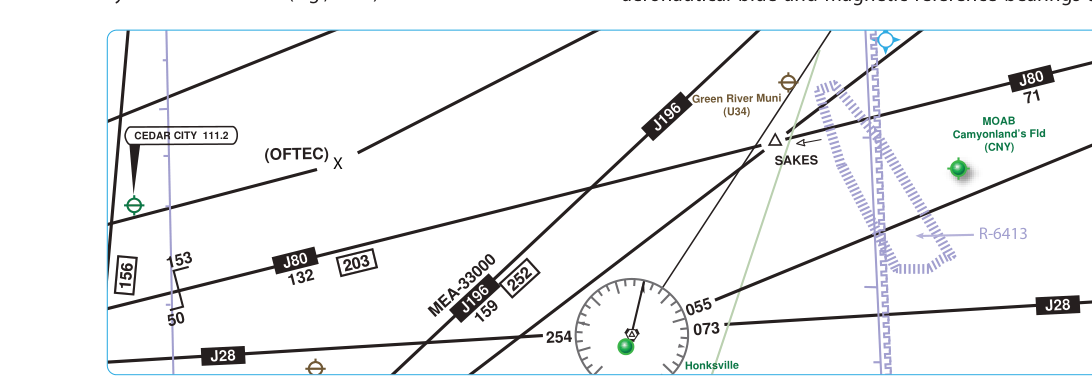
When an airline flight departs from New York bound for Los Angeles, or a corporate jet climbs through the flight levels en route to a business meeting across the country, neither flight is simply wandering through the sky. They are following a precisely defined grid of high-altitude airways that form the backbone of the United States instrument route structure. These airways — known as Jet Routes (J-Routes) and the newer Q-Routes — exist exclusively in the upper reaches of controlled airspace, providing organized, protected corridors for IFR traffic operating at or above 18,000 feet MSL.
Understanding how these routes are constructed, how they differ from one another, and how they are used is essential knowledge for any pilot pursuing an instrument rating. Even pilots who fly light general aviation aircraft should understand this system because it governs the airspace they may one day transit, and the FAA knowledge test expects familiarity with the definitions, altitudes, and operational rules that apply to J-Routes and Q-Routes.
The High-Altitude Airspace Environment
Before diving into the routes themselves, it helps to understand where they live. The Federal Aviation Regulations define Class A airspace as the airspace from 18,000 feet MSL up to and including Flight Level (FL) 600 — that is, from 18,000 feet up to approximately 60,000 feet. Within Class A airspace, all operations must be conducted under Instrument Flight Rules (IFR), regardless of weather conditions. This means every aircraft in Class A must be on an IFR clearance, equipped and current for IFR flight, and in radio contact with ATC.
Altitudes in Class A airspace are expressed in terms of flight levels, which are based on a standard altimeter setting of 29.92 inches of mercury (1013.2 hPa). FL180 corresponds to 18,000 feet on the standard altimeter, FL350 corresponds to 35,000 feet, and so on. The transition to flight levels occurs at the 18,000-foot floor of Class A airspace. Pilots transitioning from lower altitudes set their altimeters to 29.92 when climbing through 18,000 feet MSL, and reset to the local altimeter setting when descending back through that altitude.
Jet Routes (J-Routes): The Traditional High-Altitude Airway
Jet Routes are the high-altitude equivalent of the Victor airways (V-Routes) found in the low-altitude airspace structure. Like Victor airways, Jet Routes are defined by VOR radials — they connect VOR (Very high frequency Omnidirectional Range) navigation stations across the country, creating a web of navigable paths through Class A airspace.
Each Jet Route is identified by the letter J followed by a number, such as J80, J146, or J580. These routes are depicted on Enroute High Altitude charts (often called H-charts or IFR Enroute High Altitude charts), which are published by the FAA and updated on a 56-day cycle. The charts show the J-Route identifier, the VORs that define the route, magnetic courses between stations, and mileage information.
Federal airways, including Jet Routes, generally have a protected width of 4 nautical miles on each side of the centerline near the defining navaid. However, this width is not a fixed 8 nautical miles for the entire length of the route — the protected area splays (widens) with increasing distance from the VOR, since the protected width is based on angular divergence from the station rather than a constant linear distance. This protected corridor ensures that IFR-separated traffic remains clear of terrain, obstacles, and other aircraft operating outside the route structure.
Jet Routes begin at FL180 (18,000 feet MSL) and extend upward to FL450 (45,000 feet MSL). Above FL450, the airspace transitions to the ICAO high-level airspace structure used for supersonic and very high-altitude operations, though this is beyond the scope of typical instrument rating operations.
Because J-Routes are based on VOR signals, their use does require VOR reception capability. VOR signals are line-of-sight, but at high altitudes the reception range is significantly greater than at low altitudes. A high-altitude VOR (called an HVORTAC or simply a high-altitude VOR) has a standard service volume of 130 nautical miles between 18,000 feet and FL450; above FL450 up to 60,000 feet, the standard service volume is 100 nautical miles. (Below 18,000 feet, high-altitude VORs also provide 40 NM service from 1,000 to 14,500 feet AGL and 100 NM from 14,500 to 18,000 feet.) This extended service volume ensures that aircraft operating on J-Routes can maintain VOR guidance throughout the route structure, even across the longer segments typical of high-altitude flying.
Q-Routes: Area Navigation at High Altitude
As GPS and RNAV (Area Navigation) technology matured and became commonplace in cockpits, the FAA established a new category of high-altitude airways that take advantage of satellite-based navigation rather than ground-based VOR stations. These are the Q-Routes, identified by the letter Q followed by a number — for example, Q13, Q105, or Q903.
Q-Routes are high-altitude RNAV routes that are defined by geographic waypoints rather than VOR radials. Because they are not dependent on VOR ground station locations, Q-Routes can be positioned more flexibly — they can take more direct routing, follow more efficient paths over oceanic or remote areas, and be established in regions where VOR coverage is limited or nonexistent.
To fly a Q-Route, an aircraft must be equipped with an FAA-approved RNAV system — typically GPS. The required navigation accuracy for Q-Routes is RNAV 2, meaning the aircraft must be capable of maintaining lateral navigation accuracy within 2 nautical miles for at least 95 percent of flight time. Most modern flight management systems (FMS) and GPS navigators satisfy this requirement, but pilots must verify their equipment's RNAV capability and ensure the navigation database is current before filing and flying Q-Routes.
Like J-Routes, Q-Routes are depicted on Enroute High Altitude charts and apply in the FL180 to FL450 altitude range. They also carry a protected width near the centerline similar to J-Routes, though the protected area for RNAV routes is defined according to the route's navigation specification rather than VOR radial divergence. In terms of ATC procedures, Q-Routes are handled identically to J-Routes — pilots file them in their IFR flight plans and ATC issues clearances along them in the same manner.
Why These Routes Matter
The J-Route and Q-Route system exists for several critically important reasons. First, it provides organized traffic flow at high altitudes, allowing ATC to maintain separation between the many aircraft operating simultaneously in the flight levels. Without defined routes, high-altitude IFR traffic would be extremely difficult to separate and sequence.
Second, the route system enables efficient flight planning. Pilots and dispatchers can construct flight plans using established airways rather than building custom direct routes from scratch. Air traffic control computer systems are optimized to process route-based flight plans, and published airways often reflect efficient routing that has been refined over years of operational experience.
Third, the airways provide a common situational framework between pilots and controllers. When a controller clears you to fly J80, both parties immediately understand exactly where that route goes, what altitudes it covers, and what communication and navigation requirements apply.
Key Numbers and Rules
- Class A airspace floor: 18,000 feet MSL (FL180); all operations must be IFR.
- Class A airspace ceiling: FL600 (60,000 feet MSL).
- J-Route altitude range: FL180 to FL450.
- Q-Route altitude range: FL180 to FL450.
- Route width (both J and Q): 4 nautical miles each side of centerline near the navaid, splaying wider with distance from the station — not a fixed 8 NM total for the entire route.
- J-Routes are VOR-based: Aircraft must be able to receive the defining VORs.
- Q-Routes require RNAV: Specifically RNAV 2 capability (typically GPS).
- High-altitude VOR service volume: 130 nautical miles between FL180 and FL450; 100 nautical miles from FL450 up to 60,000 feet.
- Altimeter setting in Class A: Standard — 29.92 in Hg — set when climbing through 18,000 feet MSL.
- Chart source: FAA Enroute High Altitude charts, updated every 56 days.
- Airspace designation for both routes: Class A (IFR mandatory, ATC clearance required at all times).
Practical Cockpit Considerations
When a pilot files an IFR flight plan at high altitude, the flight plan route string uses the J or Q designator followed by the route number, which ATC computers recognize immediately. For example, a route might read: KORD ..KUBBS.. J80 FNT J584 DUNKK..KJFK — a string of fixes, airways, and departure/arrival identifiers that defines the complete route of flight.
Before departing on a high-altitude flight, pilots must confirm that their navigation equipment is approved and current. For Q-Routes, the GPS database must be up to date, and the system must provide RNAV 2 accuracy monitoring. Many GPS and FMS units will display a message if required accuracy cannot be guaranteed. In such cases, the pilot should not begin or continue on a Q-Route and must advise ATC.
ATC may vector aircraft off established airways for traffic sequencing, weather, or other operational reasons. When operating in Class A airspace off an airway, IFR separation is still provided, but the pilot should be aware that the terrain and obstacle protection provided by the published airway no longer applies.
Common Test Traps
- Confusing the altitude floor: J-Routes and Q-Routes begin at FL180, not FL180 exclusive. FL180 is included — you may be cleared on a J-Route at exactly FL180.
- Mixing up route types: J-Routes are VOR-based; Q-Routes are RNAV (GPS)-based. The FAA test will ask which equipment a particular route type requires.
- Forgetting the altimeter rule: Pilots must set 29.92 in Hg when reaching 18,000 feet MSL on the way up, and reset to the local altimeter setting when descending back through 18,000 feet. Failing to do so leads to altitude errors and is a common knowledge test question.
- Assuming J-Routes extend to FL600: Both J and Q routes top out at FL450. Above that, operations are outside the standard J/Q airway structure entirely.
- Overlooking RNAV 2 requirements for Q-Routes: Not every GPS installation qualifies. The aircraft's GPS must be approved for IFR RNAV operations and the database must be current — simply having GPS aboard is not enough.