When you fly IFR in the enroute environment, you cannot simply pick any altitude you like and hope for the best. The FAA has published specific minimum altitudes for every segment of the airway system, calculated to keep you safely above terrain and obstacles while also ensuring your navigation equipment actually works. Two of the most fundamental — and most frequently confused — are the Minimum Enroute Altitude (MEA) and the Minimum Obstruction Clearance Altitude (MOCA). Mastering these two values, including what each guarantees, where they appear, and how to use them operationally, is essential for both the FAA Instrument Rating knowledge test and safe real-world IFR flight.
Both altitudes are depicted on IFR enroute low-altitude charts (commonly called "Enroute Low" or "L-charts") and high-altitude charts as appropriate. They apply to Federal airways (Victor airways below 18,000 feet MSL) and other published routes. The altitudes are established by the FAA through an aeronautical study of each route segment and are legally binding minimums for IFR operations under 14 CFR Part 91.
What the MEA Guarantees
The Minimum Enroute Altitude is the lowest published altitude for an airway segment that simultaneously provides two critical assurances: obstacle clearance and acceptable navigation signal reception. When you are at or above the MEA, you are guaranteed at least 1,000 feet of clearance above all obstacles within the protected airspace corridor in non-mountainous areas, and at least 2,000 feet of clearance in designated mountainous areas. At the same time, you can be confident that your ground-based navigation receiver — a VOR, for example — will receive a usable signal from the navaid defining that airway segment.
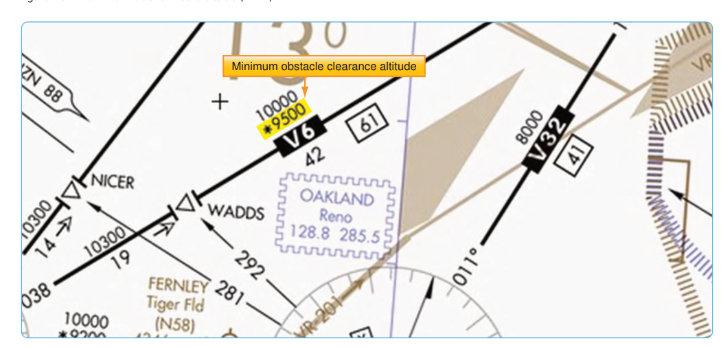
The MEA is always printed directly on the airway line on the enroute chart, typically in blue or black depending on chart edition, without any special symbol. For example, you might see "6000" printed along a Victor airway between two VORs. That means 6,000 feet MSL is the minimum you can fly that segment IFR. If two different MEAs apply to the same segment in opposite directions (directional MEAs), they will both be printed, with an arrow indicating which applies in each direction. This is common in mountainous terrain where a climb gradient requirement may differ depending on the direction of travel.
What the MOCA Guarantees
The Minimum Obstruction Clearance Altitude provides the same obstacle clearance as the MEA — 1,000 feet in non-mountainous areas, 2,000 feet in mountainous areas — but it makes no guarantee about navigation signal reception across the entire segment. Instead, the MOCA only promises acceptable VOR signal reception within 22 nautical miles of a VOR. Beyond that 22 nm buffer, navaid coverage may be unreliable or entirely absent at MOCA.
On an enroute chart, the MOCA is distinguished from the MEA by a preceding asterisk (e.g., *5200). This asterisk is your visual cue that navaid reception is not fully guaranteed across the whole segment at this altitude. The MOCA is always published at or below the MEA — it can never be higher than the MEA for the same segment. In flat terrain, the two values may be identical; in complex terrain, the MOCA can be considerably lower than the MEA because obstacle clearance is achievable at a lower altitude even when the nav signal fades out.
Practical Application: When Can You Use the MOCA?
Under normal IFR operations, you are expected to fly at or above the MEA. However, 14 CFR 91.177 does permit operating at an altitude below the MEA but at or above the MOCA, without requiring specific ATC approval, provided the aircraft's position can be identified as within 22 nm of the VOR concerned. The practical scenario most relevant to instrument students is this: if you are assigned or elect an altitude that equals or exceeds the MOCA but is below the MEA, that operation is only legal if you are within 22 nm of the defining VOR. In practice, ATC will typically not assign such an altitude without good reason, such as traffic separation or descent management, but the regulatory basis for using the MOCA itself does not depend on ATC approval — it depends on the 22 nm distance requirement in 91.177.
A more immediate real-world relevance is during loss of communications (NORDO) procedures. If you lose radio contact while enroute, regulations require you to fly the highest of several altitudes, one of which is the MEA — not the MOCA — for the route segment you are flying. This underscores that the MEA is the standard enroute floor, and the MOCA is a backup tool with very specific limitations.
Pilots flying GPS-based IFR routes should also be aware that the 22 nm navaid reception limitation is primarily a VOR-based concept. If your route is authorized for GPS navigation and your equipment meets TSO standards, signal reception concerns for VORs on a given segment become less operationally constraining — but the terrain and obstacle clearance guarantees of the MEA and MOCA still apply regardless of navigation source, because those values are computed from terrain surveys, not radio coverage.
Key Numbers and Rules
- MEA obstacle clearance: 1,000 feet AGL in non-mountainous areas; 2,000 feet AGL in designated mountainous areas, across the full protected airway width.
- MOCA obstacle clearance: Same as MEA — 1,000 feet / 2,000 feet — but navigation signal reception is only guaranteed within 22 nm of the defining VOR.
- Chart symbology: MEA appears as a plain number on the airway; MOCA appears with an asterisk prefix (e.g., *4300).
- MOCA is always ≤ MEA: The MOCA can never exceed the MEA for the same segment and direction.
- Directional MEAs: When two MEAs appear with arrows, each value applies only in the direction the arrow points — relevant when flying mountainous routes where the required climb gradient differs by direction.
- Regulatory basis: 14 CFR 91.177 establishes the requirement to fly at or above the MEA (or MOCA when the 22 nm distance requirement is met) in IFR conditions in controlled airspace.
- Protected corridor width: Victor airways extend 4 nm either side of the centerline (8 nm total); this corridor defines the lateral bounds within which obstacle clearance is assured at the MEA/MOCA.
MEA vs. MOCA: The Core Distinction
Think of the MEA as the complete package — you get both terrain clearance and navigation coverage. The MOCA is the bare minimum for obstacle clearance only, with just a partial navigation guarantee near the navaid. A helpful way to remember this: the M in MOCA stands for Minimum — as in, it gives you the absolute floor for obstacle clearance, but nothing more in terms of nav signal. The MEA, by contrast, is the operational standard for IFR enroute flight.
In mountainous or remote terrain, the difference between the MEA and MOCA can be significant — sometimes 1,000 feet or more. When planning IFR routes, pilots should note segments where the MEA appears unusually high and investigate why. A very high MEA relative to apparent terrain may indicate a navaid reception issue (the MEA was raised to guarantee signal coverage), while a much lower MOCA on the same segment confirms that the terrain itself is actually clearable at the lower altitude — the navaid just doesn't reach there effectively.
Common Test Traps
- Confusing the asterisk: Students often forget that the asterisk (*) precedes the MOCA, not the MEA. On a busy chart with many numbers, always look for that asterisk before deciding which value you are reading.
- Assuming MOCA guarantees full navaid coverage: The MOCA only guarantees VOR reception within 22 nm of the VOR. Beyond that, you may have obstacle clearance but a degraded nav signal — this is a very common trap on knowledge test questions.
- Thinking MOCA can exceed MEA: The MOCA is always equal to or lower than the MEA. An answer choice suggesting MOCA is higher than MEA is always wrong.
- Directional MEA confusion: When two MEAs appear on a segment, each applies only in its indicated direction of flight. Using the lower one when flying toward the higher-MEA side is a dangerous and testable error.
- Using MOCA for NORDO altitude selection: During lost communications, the regulatory requirement is to fly the MEA (or other applicable higher altitude per 91.185), not the MOCA. Do not substitute MOCA in lost-comm scenarios.