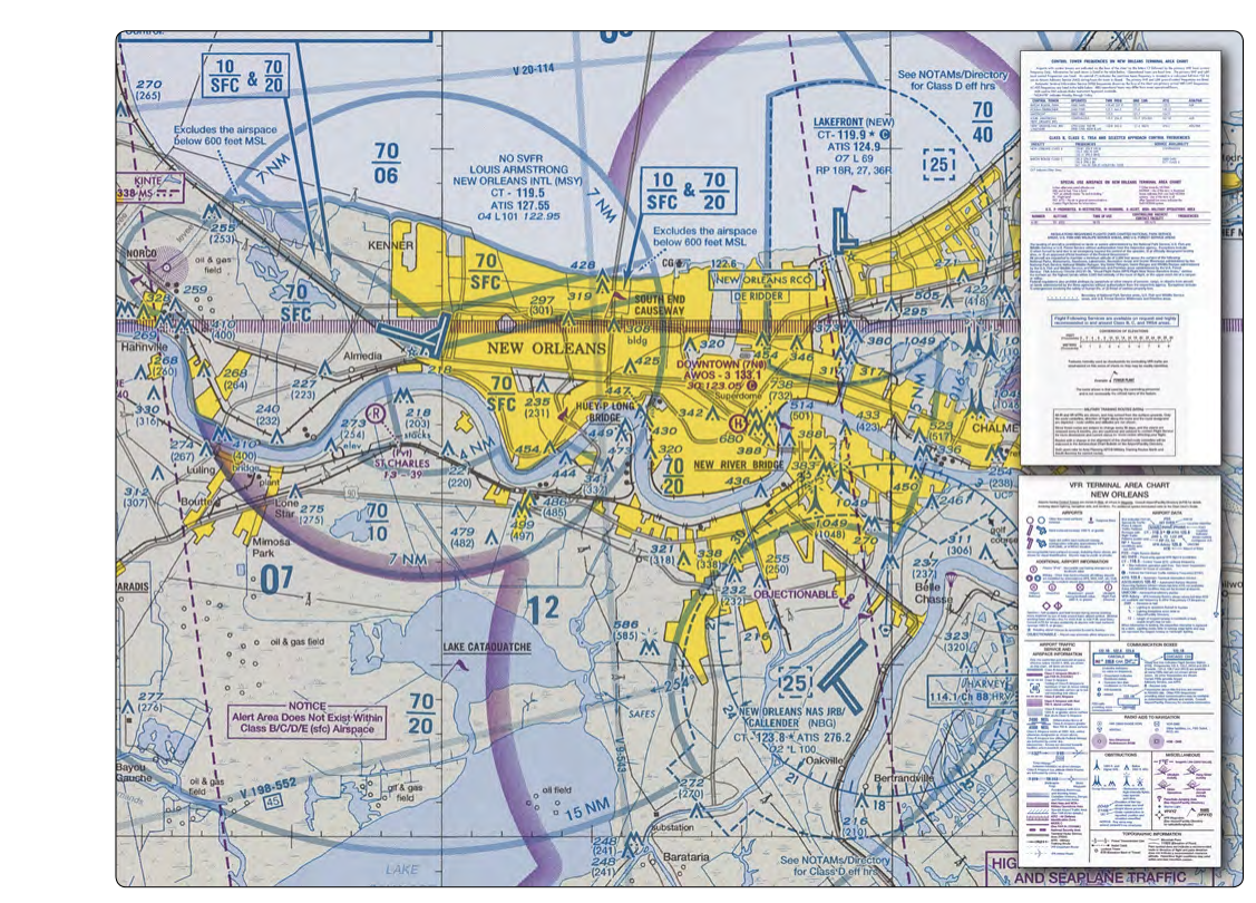
Flying into or around a major metropolitan area can feel like navigating a maze. Towering Class B airspace, busy air carrier routes, and complex surface streets of the terminal environment all compete for your attention. The FAA recognized this challenge and created two complementary tools specifically designed to help VFR pilots thread the needle: VFR Flyway Planning Charts and Terminal VFR Charts (commonly called Terminal Area Charts, or TACs). Together, these resources give student pilots not only a legal path through busy airspace but a clear picture of the terrain, obstacles, and landmarks that define one of the most demanding phases of flight.
Understanding these charts is not just about passing the FAA knowledge test — it is about building the situational awareness that keeps you safe when controllers are too busy to hold your hand and the airspace is full of faster, heavier iron.
What Are Terminal Area Charts (TACs)?
Terminal Area Charts are large-scale VFR sectional-style charts printed specifically for the vicinity of Class B airspace. Where a standard VFR Sectional Chart uses a scale of 1:500,000 (roughly 1 inch = 6.86 nautical miles), a TAC uses a scale of 1:250,000 — exactly twice as detailed. That doubled resolution means roads, runways, bodies of water, towers, and airspace boundaries are all much easier to read and correlate with the view out the window.
TACs are published by the FAA's Aeronautical Information Services and are updated on a 56-day cycle, the same cycle as Sectional Charts. Each TAC covers the immediate area surrounding a major hub — cities like Atlanta, Chicago O'Hare, Los Angeles, Dallas/Fort Worth, New York, and about two dozen others across the contiguous United States. The Class B airspace depiction on a TAC shows all the shelf layers with their associated floor and ceiling altitudes, the Mode C veil (typically a 30-nautical-mile ring requiring an encoding altimeter and ADS-B Out), satellite airports, VORs, fixes, and the same legend symbology used on Sectionals, so learning one chart type directly transfers to the other.
Because TACs are published as separate documents, you must specifically obtain one for the area you are flying. Using a standard Sectional alone when operating near Class B airspace is legal but impractical — the smaller scale makes it genuinely difficult to determine which side of a shelf boundary you are on, and that ambiguity can lead to an inadvertent airspace incursion.
What Are VFR Flyway Planning Charts?
Printed on the reverse side of most Terminal Area Charts, VFR Flyway Planning Charts take the complex airspace depiction one step further. Rather than simply showing airspace boundaries and topography, they overlay suggested VFR routes that allow pilots to transit around or beneath Class B airspace without requiring an ATC clearance to enter the Class B itself.
Each flyway is depicted as a broad arrow or corridor with a recommended altitude range and, in many cases, suggested headings and key visual checkpoints. The corridors are designed to keep VFR traffic below the lowest floor of the overlying Class B shelves, through gaps in the airspace structure, or around the outer edges entirely. Textual notes may specify altimeter settings, suggested radio frequencies for advisory purposes, and prominent landmarks like highways, rivers, or stadiums that serve as reliable visual references in a sea of urban sprawl.
It is critical to understand that VFR Flyways are advisory only. They are not regulatory airspace designations. Flying a flyway does not guarantee separation from other traffic, and it does not replace the need for a proper weather briefing, fuel planning, or good aeronautical decision making. However, in practice, flyways channel VFR traffic in predictable ways, which means that other pilots who have done their homework are likely to be found along the same routes — both a comfort and a reminder to maintain vigilant see-and-avoid scanning.
How VFR Flyways Interact with Class B Airspace Rules
Under 14 CFR Part 91.131, no person may operate an aircraft within Class B airspace without a specific ATC clearance. There is no automatic right of passage just because you are VFR and the weather is good. Class B airspace typically extends from the surface up to 10,000 feet MSL, with tiered shelves that fan outward from the primary airport, and its dimensions are unique to each location.
VFR Flyways are engineered to route traffic through the gaps — altitude windows and geographic corridors that exist beneath or outside the Class B shelves. If a corridor shows a recommended altitude of 1,500 feet MSL, that means the floor of the Class B above you is at least slightly higher (often 2,000 or 2,500 feet), giving you legal clearance without a Class B entry authorization. You must still comply with all VFR cloud clearance and visibility requirements: in Class B airspace and in the controlled airspace immediately surrounding it, the minimums change depending on the class of airspace you are actually in at your chosen altitude.
Outside the Class B boundary but still near a major terminal, you may find yourself in Class C, Class D, or Class E airspace, each with its own communication and weather minimum requirements. The TAC depicts all of these airspace layers simultaneously, which is one reason the larger scale is so valuable — you can actually read the fine print of each shelf's altitude label without a magnifying glass.
Practical Use in Flight Planning
When planning a cross-country or local flight near a Class B terminal area, an effective workflow runs like this. First, obtain the current TAC for that area and study the structure of the Class B airspace — note the floors, ceilings, and lateral extent of each shelf. Second, flip the chart over and examine the VFR Flyway Planning Chart. Identify which corridor best matches your origin, destination, and performance capabilities. Note the suggested altitudes, key fixes, and any speed or radio advisories. Third, compare your planned altitude against the sectional and TAC to confirm you will remain below any Class B shelf. Fourth, brief yourself on the major visual landmarks along the flyway so you can navigate it confidently using pilotage, even if your GPS fails.
In the cockpit, fly the flyway as you would any route — track your position continuously, maintain the recommended altitude with precision (a 200-foot deviation in a tight corridor can put you in the Class B), and keep your radio on the appropriate advisory or approach frequency. Even if you are not required to talk to ATC, monitoring the frequency gives you traffic awareness that no chart can provide.
Key Numbers and Rules
- TAC scale: 1:250,000 — twice the detail of a standard Sectional Chart (1:500,000).
- Publication cycle: 56 days, same as VFR Sectional Charts.
- Class B entry: Requires an explicit ATC clearance per 14 CFR 91.131 — VFR alone is not sufficient.
- Mode C veil: Within 30 nautical miles of a Class B primary airport, an encoding altimeter (Mode C or ADS-B Out) is required from the surface up to 10,000 feet MSL.
- VFR Flyways: Advisory only — they suggest routes but carry no regulatory authority.
- Availability: Flyway charts are printed on the reverse of most (not all) TACs; check before you fly an unfamiliar terminal area.
- Currency: Always use the current edition — airspace boundaries and TAC depictions can change with each 56-day cycle.
Common Test Traps
- Confusing scale: The FAA knowledge test may ask which chart shows the most detail near a Class B airport. The TAC at 1:250,000 is more detailed than a Sectional at 1:500,000. More detail = smaller denominator = larger-appearing features.
- Thinking flyways grant Class B access: VFR Flyways route you around or beneath Class B, not through it. If the flyway altitude would place you inside a Class B shelf, you need ATC clearance regardless of what the chart suggests.
- Assuming all TACs include a Flyway chart: Most do, but not all terminals publish a flyway chart on the reverse side. Never assume it will be there for every airport.
- Forgetting the Mode C veil: You can be well outside the Class B boundary and still need Mode C (or ADS-B Out) equipment if you are within 30 nm of the primary airport below 10,000 feet MSL.
- Treating flyway altitudes as floors: The altitudes shown on flyways are recommended cruising levels for traffic flow — they are not minimums or maximums. You must still comply with VFR cloud clearance requirements and verify that your altitude does not penetrate the overlying Class B.
VFR Flyway and Terminal Area Charts represent the FAA's practical acknowledgment that busy airspace demands better tools, not just better rules. Study them thoroughly, carry the current edition, and use them together — the large-scale situational picture of the TAC combined with the route guidance of the Flyway chart gives you a level of preparation that turns an intimidating terminal environment into manageable, logical airspace.