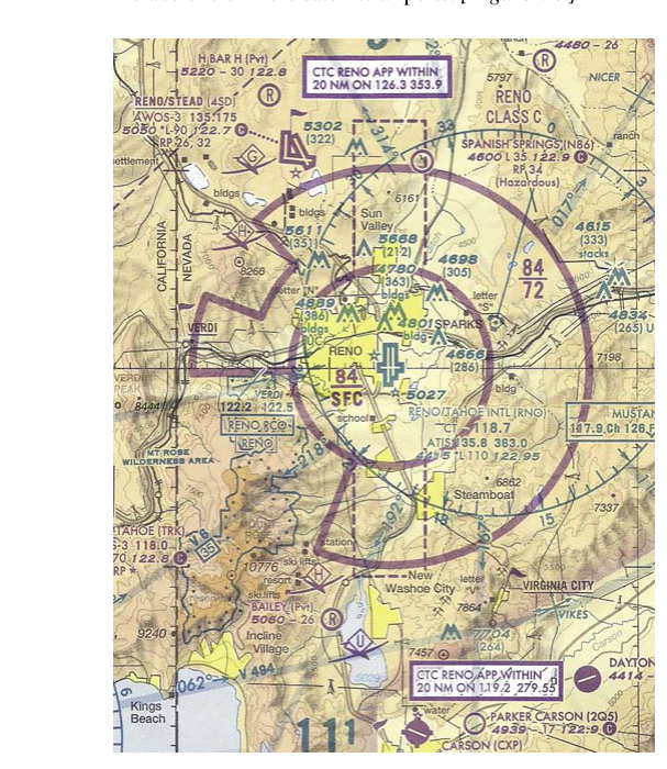
Class C airspace is one of the most commonly encountered controlled airspace environments for both manned and unmanned aircraft operations. Built around airports that handle significant commercial and general aviation traffic, Class C airspace is designed to provide a safe, organized flow of aircraft through sequencing services managed by radar-equipped Approach Control facilities. For remote pilots operating under Part 107, understanding the exact shape, dimensions, and entry requirements of Class C airspace is not just a knowledge test subject — it is an everyday operational reality that directly affects where and when you can legally fly your small unmanned aircraft system (sUAS).
The FAA establishes Class C airspace at airports that meet specific traffic volume and operational criteria, primarily those served by an operational Air Traffic Control (ATC) tower and a Terminal Radar Approach Control (TRACON) facility. While Class B surrounds the nation's busiest hub airports, Class C represents the next tier: airports such as regional hubs and medium-sized commercial service airports. Knowing the structure, the regulatory requirements, and the practical steps for obtaining authorization is essential for any Part 107 remote pilot who wants to operate legally and safely in the airspace around these airports.
The Shape and Dimensions of Class C Airspace
Class C airspace is typically depicted on sectional aeronautical charts as magenta (solid) circles. Its standard configuration resembles an upside-down wedding cake with two tiers, though the FAA may modify exact dimensions at individual airports based on local terrain, traffic patterns, and other factors. The published standard configuration is as follows:
- Inner core (surface area): A circle with a radius of approximately 5 nautical miles (NM) centered on the primary airport. This area extends from the surface up to 1,200 feet above ground level (AGL) in most standard configurations.
- Outer shelf: A ring extending from approximately 5 NM out to 10 NM from the airport reference point. The outer shelf generally begins at 1,200 feet AGL and extends up to 4,000 feet AGL, though the floor altitude can vary.
It is important to understand that these are standard dimensions and that site-specific Class C airspace will have its exact boundaries and altitudes published on sectional charts and in the Chart Supplement (formerly known as the Airport/Facility Directory). The magenta numbers depicted on the chart show the ceiling and floor of each segment in hundreds of feet mean sea level (MSL), not AGL, so pilots and remote pilots must be familiar with the local airport elevation to translate those values into practical AGL numbers.
Beyond the 10 NM outer ring, the FAA defines an outer area that typically extends to about 20 NM from the primary airport. The outer area is not depicted on charts as Class C airspace itself, but participating aircraft in this zone are offered radar sequencing services. For Part 107 purposes, the outer area does not carry the same mandatory communication and authorization requirements as the formal Class C airspace depicted on charts.
Entry Requirements Under Part 107
For manned aircraft, Class C airspace requires two-way radio communication with ATC before entry — a two-way contact is established when the controller acknowledges the aircraft by its call sign. No explicit clearance phrase is required for manned aircraft, but the controller must respond using the aircraft's call sign.
For remote pilots operating under 14 CFR Part 107, the rules are stricter and more explicit. Prior authorization from ATC is required before operating an sUAS in Class C airspace. Simply establishing radio contact or notifying ATC is not sufficient — you must receive actual authorization. This is a critical distinction that the FAA knowledge test frequently targets.
The FAA provides two primary pathways for Part 107 remote pilots to obtain Class C airspace authorization:
- LAANC (Low Altitude Authorization and Notification Capability): LAANC is an automated, near-real-time authorization system available at many airports with Class C airspace. Remote pilots submit requests through an FAA-approved UAS service supplier app, and authorization can be granted almost instantly for operations at or below published UAS Facility Map altitudes. LAANC authorizations are altitude-specific and grid-based, so the approved altitude may vary depending on exactly where within the Class C you intend to fly.
- DroneZone (FAA's online portal): For operations that exceed the altitude ceilings shown on the UAS Facility Map, or at airports where LAANC is not available, remote pilots can apply through the FAA DroneZone website for a formal airspace authorization. This process is not instantaneous and may take days to weeks, so advance planning is essential.
Remote pilots must have their authorization in hand before beginning operations. Flying in Class C airspace without authorization is a violation of 14 CFR 107.41 and can result in civil penalties, certificate suspension, or revocation.
Why Class C Airspace Matters for sUAS Operations
Class C airports handle a mix of commercial airline traffic, cargo operations, and general aviation, all of which operate under instrument flight rules (IFR) and visual flight rules (VFR). The radar approach control facility is actively sequencing arrivals and departures on precise paths that often begin at relatively low altitudes — sometimes only a few hundred feet AGL near the outer edges of the Class C surface area. An sUAS flying without authorization could present a mid-air collision hazard to aircraft on instrument approaches or climbing departures.
Additionally, because the sUAS itself is not equipped with a transponder or ADS-B Out in most configurations, ATC cannot independently detect it on radar. This places the entire burden of coordination on the remote pilot, which is precisely why prior authorization — not just notification — is mandatory. The authorization process ensures that ATC is aware of and has approved the unmanned operation, so controllers can manage traffic safely.
Key Numbers and Rules
- Inner core radius: Approximately 5 NM from the primary airport, surface to ~1,200 feet AGL.
- Outer shelf radius: Approximately 5 to 10 NM from the airport, floor ~1,200 feet AGL to ceiling ~4,000 feet AGL.
- Outer area: Approximately 20 NM radius — not charted as Class C; radar services available but Part 107 authorization not required solely for this zone.
- Chart depiction: Solid magenta circles on sectional charts; altitudes shown in MSL in hundreds of feet.
- Part 107 requirement: Prior ATC authorization required under 14 CFR 107.41 — not just communication.
- LAANC: Provides near-real-time authorization up to UAS Facility Map ceilings at participating airports.
- DroneZone: Required for altitudes above Facility Map ceilings or at airports without LAANC coverage.
- Manned aircraft entry rule: Two-way radio communication established before entry (call sign acknowledged by ATC).
Common Test Traps
- Communication vs. Authorization: Many test questions try to trick students into thinking that simply contacting ATC on the radio — the manned aircraft rule — is sufficient for Part 107 operations. It is not. Remote pilots must receive explicit authorization before entering Class C airspace.
- MSL vs. AGL altitudes on charts: Class C ceiling and floor values on sectional charts are in MSL. At an airport with a field elevation of 800 feet MSL, a charted floor of "12" (1,200 feet MSL) is only 400 feet AGL. Failing to account for field elevation leads to misidentifying where the airspace begins vertically.
- Outer area confusion: The outer area (up to ~20 NM) is not the same as Class C airspace. The FAA tests whether you know that mandatory authorization applies only within the charted magenta boundaries, not the outer area.
- LAANC altitude ceilings vary by grid: Students sometimes assume that LAANC approval at one altitude applies uniformly across the entire Class C surface area. In reality, the UAS Facility Map shows different approved altitude ceilings for different grid squares, and some grids may show zero feet AGL, meaning no LAANC authorization is available at that location.
- Standard vs. site-specific dimensions: The 5 NM / 10 NM dimensions are standard, but Class C airspace at specific airports may have modified dimensions. Always consult the current sectional chart and Chart Supplement for the exact boundaries at the airport in question.