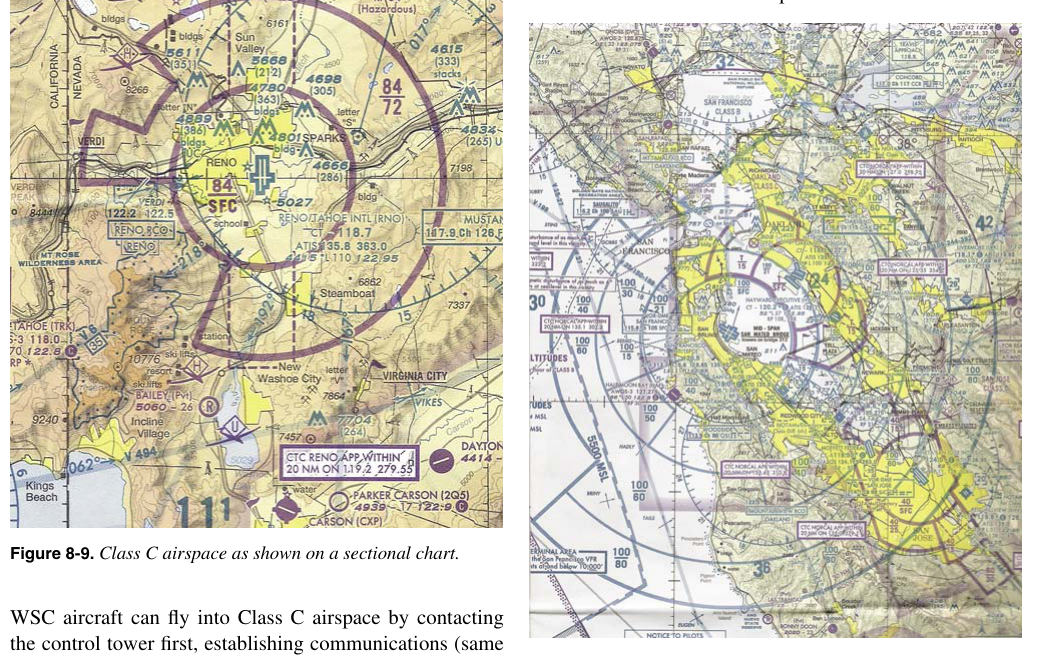
Class B airspace is the most tightly controlled airspace category in the United States National Airspace System (NAS). Built like an upside-down wedding cake, it envelopes the busiest commercial airports in the country — think Atlanta Hartsfield-Jackson, Los Angeles International, and Chicago O'Hare — where the sheer volume of airline traffic demands the highest level of separation and communication. For student pilots and remote pilots studying for the FAA Part 107 knowledge test, Class B airspace is one of the most frequently tested topics, and for good reason: operating in or near it without proper authorization can be dangerous and carries serious regulatory consequences.
This article breaks down exactly what Class B airspace is, how it is shaped, what the rules require of both manned and unmanned aircraft, and how to spot the traps the FAA loves to include on knowledge-test questions.
The Layered "Wedding Cake" Structure
Class B airspace is defined by a set of circular areas centered on the primary airport. Rather than a single uniform cylinder, Class B airspace is made up of multiple tiers, each extending outward from the airport at successively greater radii and beginning at successively higher altitudes. The result — when viewed from the side — resembles the tiered layers of a wedding cake, or more technically, an inverted pyramid or an upside-down wedding cake.
The innermost tier starts at the surface of the primary airport and typically extends outward to a radius of about 5 nautical miles (NM), reaching from the surface up to the published upper limit, which is commonly 10,000 feet mean sea level (MSL). The next tier outward typically begins at a higher floor altitude — perhaps 1,200 or 2,000 feet MSL — and extends further from the airport, often to about 10 NM. The outermost tier may begin as high as 3,000 or 4,000 feet MSL and extend out to approximately 20 NM from the primary airport. These exact dimensions vary by location and are published on sectional charts and in the Chart Supplement U.S. The specific lateral limits and floor altitudes for each tier are depicted on sectional aeronautical charts using solid blue lines.
On a sectional chart, Class B airspace is shown in solid blue. The ceiling and floor altitudes are labeled in hundreds of feet MSL — for example, "100/SFC" means the airspace extends from the surface up to 10,000 feet MSL at that location. The two-number format is always ceiling over floor; "100/40" means from 4,000 feet MSL up to 10,000 feet MSL. Recognizing these labels instantly is a core skill for any knowledge-test candidate.
Entry Requirements: The ATC Clearance Rule
The single most important rule for Class B airspace is this: no aircraft — manned or unmanned — may operate within Class B airspace without first receiving an explicit ATC clearance. This is codified in 14 CFR Part 91.131 for manned aircraft. Unlike Class C or Class D airspace, where establishing two-way radio communication is sufficient, Class B requires you to hear the specific phrase "cleared into Class Bravo airspace" (or equivalent wording) from the controller. Simply calling ATC and getting a response such as "standby" does not constitute clearance, and entering the airspace in that situation would be a violation.
For manned aircraft, additional equipment requirements apply within Class B airspace. Aircraft must be equipped with a Mode C altitude-encoding transponder and, in most primary Class B airspace areas, an Automatic Dependent Surveillance-Broadcast Out (ADS-B Out) system is required. There is no requirement to hold a private pilot certificate to act as pilot in command within Class B airspace; student, sport, and recreational pilots may operate there provided they meet the specific training and logbook endorsement requirements of 14 CFR 61.94 and 61.95.
Part 107 Remote Pilot Considerations
For drone operators working under 14 CFR Part 107, the Class B airspace rules are critically important because most Class B airspace begins at the surface around the primary airport, meaning a remote pilot cannot simply fly below the floor of an upper tier and assume they are clear. The innermost core extends from the surface upward, and the floors of outer tiers may be low enough to encompass typical small UAS operating altitudes of 400 feet AGL or less.
Under Part 107, a remote pilot must obtain airspace authorization before operating a small unmanned aircraft system (sUAS) in Class B airspace. The FAA has implemented two main pathways for this authorization. The first is the Low Altitude Authorization and Notification Capability, commonly known as LAANC, which provides near-real-time automated airspace authorization for operations at or below specific altitudes in many controlled airspace areas. LAANC authorizations are issued through FAA-approved UAS Service Suppliers (USS) and are often processed within seconds through a smartphone app. The second pathway is submitting a manual airspace authorization request through the FAA DroneZone website (at drone.faa.gov), which is the method used when LAANC is unavailable or when a waiver of standard operating limitations is needed.
Remote pilots should note that LAANC coverage and approved altitude ceilings vary by location. In some Class B areas near an airport's surface, LAANC may authorize operations only up to 0 feet AGL — effectively prohibiting flight without a manual waiver. It is the remote pilot's responsibility to check the applicable UAS Facility Map (UASFM) before flight to understand what altitudes, if any, are available through LAANC at a given location.
Why Class B Airspace Exists
Class B airspace exists because high-density terminal environments around major airports present extreme collision-risk challenges. Large commercial aircraft arrive and depart continuously on instrument flight rules (IFR) clearances, often in reduced visibility conditions. ATC actively sequences and separates all traffic. Requiring a clearance for entry ensures that controllers maintain positive control over every aircraft — including small drones — within this high-stakes environment. The layered structure mirrors the typical arrival and departure paths of commercial jets: aircraft close to the airport tend to be at lower altitudes (near the surface on final approach or just after takeoff), while aircraft farther out are at progressively higher altitudes as they climb or descend along the approach corridor.
Key Numbers and Rules
- ATC clearance required: Mandatory before any aircraft enters Class B airspace; communication alone is not clearance.
- Depicted on charts in solid blue: Class B lateral limits are drawn with solid blue lines on sectional charts; Class C uses solid magenta.
- Altitude label format: "Ceiling/Floor" in hundreds of feet MSL — "100/SFC" = surface to 10,000 feet MSL.
- Typical outer radius: Approximately 20 NM from the primary airport, though this varies by location.
- Mode C veil: Even aircraft that do not enter Class B airspace must carry a Mode C transponder within 30 NM of the primary airport — this is the "Mode C veil."
- Part 107 authorization: Remote pilots must obtain LAANC or DroneZone authorization before flying a sUAS in Class B airspace.
- ADS-B Out: Required for manned aircraft operating in Class B airspace and within the 30 NM Mode C veil.
- Student pilot note: Student pilots require specific logbook endorsements to operate at airports within Class B airspace; this does not apply to remote pilots but may appear on knowledge-test scenario questions.
Common Test Traps
- "Two-way communication" is not enough: A very common mistake is assuming that contacting ATC and hearing your callsign is sufficient to enter Class B airspace. You must receive an explicit clearance — the words matter. This is the number-one tested misconception about Class B entry.
- Reading the altitude label incorrectly: The format is always ceiling over floor. Students sometimes reverse these, reading "100/40" as a floor of 10,000 feet. Remember: top number is the ceiling.
- Assuming outer tiers start at the surface: Only the innermost core of Class B airspace necessarily begins at the surface. Outer tiers have higher floor altitudes — but those floors may still be below your planned drone altitude, so always check the specific tier that applies to your location.
- Confusing Class B and Class C chart symbology: Class B uses solid blue lines; Class C uses solid magenta lines. On a black-and-white reproduction, this distinction can be easy to miss. Color recognition on sectional charts is testable.
- Ignoring the Mode C veil: The 30 NM Mode C veil extends beyond the outer boundary of Class B airspace. Aircraft operating outside Class B airspace but within 30 NM of the primary airport still need a Mode C transponder and ADS-B Out. For Part 107 operators, this is less directly applicable, but the concept appears on knowledge-test questions about what manned aircraft are required to carry.