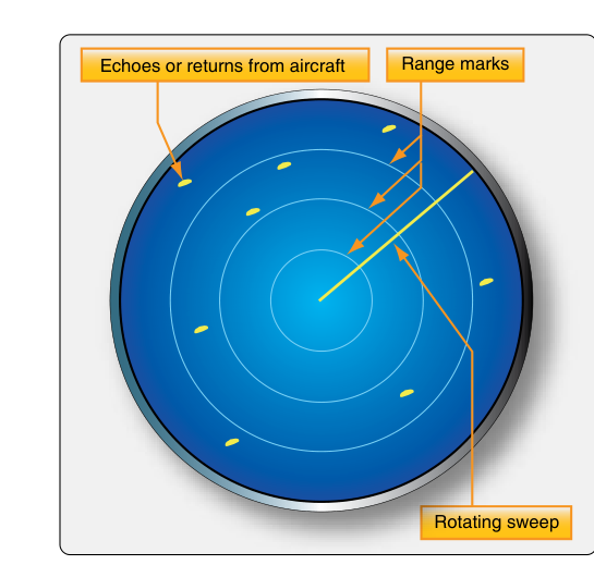
When you fly IFR in the United States, you are flying inside a system specifically engineered to keep you separated from terrain, obstacles, and other aircraft — even when you cannot see any of them. The backbone of that system is ATC radar. From the moment you enter controlled airspace on an IFR clearance, radar-equipped controllers track your position, issue traffic advisories, assign headings, and coordinate handoffs between facilities. Understanding what radar services are actually provided, how they work technically, and what their limitations are is essential both for the Instrument Rating knowledge test and for staying safe every time you file IFR.
This article walks through the full scope of ATC radar services for IFR flights — the types of radar in use, the specific services controllers provide, separation standards, and the critical points where pilot and controller responsibilities intersect.
Types of Radar Used by ATC
ATC uses two complementary radar technologies to paint a picture of the airspace.
Primary Surveillance Radar (PSR) works by transmitting a radio pulse and listening for the reflection that bounces off an aircraft's metal skin. The controller sees a simple paint — a bright spot on the scope — but gets no automatic altitude information or aircraft identification from the primary return alone. Weather and terrain can also produce returns, adding clutter.
Secondary Surveillance Radar (SSR), also called the Air Traffic Control Radar Beacon System (ATCRBS), interrogates the transponder aboard your aircraft. When your Mode C transponder replies, the radar displays a data block next to your target that shows your aircraft's identification (linked to the discrete four-digit code you squawk via Mode A, which the controller associates with your flight plan) and pressure altitude (via Mode C). This is why ATC can tell you "traffic, twelve o'clock, five miles, 8,500 feet" — the altitude readout is coming directly from the encoding altimeter or blind encoder in the other aircraft's transponder system. Mode S transponders add a discrete 24-bit address unique to each aircraft and allow selective interrogation, reducing radio frequency congestion.
Terminal radar facilities (TRACONs) typically use short-range, high-resolution radar well suited to the complex traffic flows around busy airports. En route centers (ARTCCs) use longer-range radar that may have a slower antenna rotation rate, which affects how quickly the display updates. ADS-B (Automatic Dependent Surveillance–Broadcast) is increasingly integrated into the display picture, but the underlying radar infrastructure remains the primary separation tool for IFR operations.
Radar Services Provided on IFR Flights
The AIM describes several categories of radar service. As an IFR pilot, you receive these automatically while in radar contact — you do not need to request them.
Radar Separation
This is the foundational service. Once a controller has established radar contact with your aircraft, they are responsible for maintaining approved separation between you and all other IFR traffic in their sector. The standard en route horizontal separation is 5 nautical miles between aircraft at the same altitude. In terminal areas and in some high-density or precision environments, controllers may apply 3 nautical miles of separation when authorized to do so. Vertical separation of 1,000 feet applies below FL290 (and between FL290 and FL410 under Reduced Vertical Separation Minimum, RVSM, with equipped and approved aircraft). Above FL410, vertical separation increases to 2,000 feet.
Radar separation replaces the procedural (non-radar) separation standards that controllers must use when radar coverage is lost. Non-radar separation relies on time, distance, and position reports — which is why controllers revert to position reporting requirements when radar contact is lost.
Traffic Advisories
Controllers issue traffic advisories — often called traffic alerts — to advise you of potentially conflicting traffic that the radar shows. A typical call sounds like: "Cessna 34 Bravo, traffic, two o'clock, eight miles, northbound, altitude unknown, type unknown." The clock position is relative to your ground track, not magnetic heading. Altitude unknown means the target has no Mode C readout (perhaps a primary-only target or a transponder without altitude encoding).
It is critical to understand: traffic advisories do not relieve you of see-and-avoid responsibility. ATC may be working many aircraft and may not call every piece of traffic. You must still scan for conflicting aircraft and maneuver if you see a collision threat, regardless of whether ATC has issued an advisory.
Safety Alerts
Safety alerts are a higher-priority service. There are two types:
- Terrain/Obstruction Alert: Issued when the controller observes your aircraft is at an altitude that, in their judgment, places you at risk of controlled flight into terrain or an obstacle. This is a critical warning — if ATC issues one, comply immediately and report your altitude.
- Aircraft Conflict Alert: Issued when the radar indicates another aircraft is converging on your position and the controller believes a collision hazard exists. The controller will suggest an evasive maneuver if time permits.
Safety alerts are mandatory — controllers must issue them whenever the situation is recognized. However, workload and radar limitations mean they cannot be guaranteed in every situation. They are a safety net, not a substitute for your own situational awareness.
Radar Vectors
Controllers routinely issue radar vectors — specific headings — to sequence traffic, provide shortcuts, steer you around weather, or position you for an instrument approach. When you are being vectored, ATC is responsible for terrain and obstruction clearance as long as you are above the Minimum Vectoring Altitude (MVA) in terminal areas or the Minimum IFR Altitude (MIA) in the en route environment. The MVA is typically lower than published procedure altitudes, which is why ATC can sometimes descend you below the initial approach fix altitude while on vectors — they are using their own charts that account for local terrain.
If ATC issues a vector that will take you into IMC or below safe altitudes for any reason — including equipment malfunction — you have both the authority and the responsibility to advise ATC and request an amended clearance. You are never required to accept a clearance you believe to be unsafe.
Radar Approaches
At some military and civilian facilities, controllers can conduct Surveillance Radar Approaches (ASR) and Precision Approach Radar (PAR) approaches. In an ASR approach, the controller provides heading guidance and tells you when to begin descent; the pilot executes the approach using published step-down altitudes. A PAR provides both lateral and vertical guidance with the controller issuing precise corrections, much like an ILS but spoken over the radio. These approaches are relatively rare at civilian airports today but remain a useful emergency option.
Radar Contact and Loss of Radar Contact
The phrase "radar contact" from ATC is significant — it means the controller has positively identified your aircraft on radar and has assumed responsibility for radar separation. Until you hear those words, you are not in radar contact, and non-radar procedures apply.
When a controller says "radar contact lost" or "radar service terminated," you immediately revert to procedural IFR. That means reporting over compulsory reporting points, maintaining your last assigned altitude unless amended, and operating as if radar services do not exist. In practice, controllers try to hand you off to another facility before radar coverage ends, but gaps in coverage exist — especially in mountainous or low-altitude environments.
Why Radar Services Matter to IFR Pilots
Flying IFR in IMC means you are trusting the system. A failure to understand what ATC radar does — and does not — protect you from can be fatal. Radar only shows what the transponder and radar reflectivity reveal; it does not show wake turbulence, icing conditions, or convective cells inside your route. You remain responsible for weather avoidance, wake turbulence avoidance (though ATC will apply wake turbulence separation standards for heavy aircraft), and ultimately for the safety of your flight.
ATC also cannot guarantee continual radar coverage at all altitudes and locations. Radar has line-of-sight limitations — at low altitudes in mountainous terrain, your transponder return may disappear even though you are flying legally. This is why Minimum Enroute Altitudes (MEAs) and Off-Route Obstacle Clearance Altitudes (OROCAs) exist, and why flying at or above them is not optional.
Key Numbers and Rules
- 5 NM — standard en route radar separation (horizontal)
- 3 NM — reduced radar separation in terminal areas (when authorized)
- 1,000 ft — standard vertical separation below FL290
- 2,000 ft — vertical separation above FL410
- Mode C transponder required in Class A, B, C airspace and above 10,000 ft MSL (with exceptions per 14 CFR 91.215)
- Radar contact must be explicitly confirmed by ATC — never assumed
- Safety alerts are mandatory for controllers; terrain/obstruction and aircraft conflict alerts are both required
- Radar vectors: ATC is responsible for obstruction clearance above the MVA/MIA while vectoring you
Common Test Traps
- Assuming radar contact is automatic. Radar contact must be positively established and confirmed by ATC. "N1234A, radar contact" is the trigger — not simply filing IFR or contacting a TRACON frequency.
- Confusing traffic advisories with collision avoidance responsibility. Traffic advisories are advisory only. You must maintain see-and-avoid vigilance regardless of whether ATC calls traffic. TCAS/ACAS resolution advisories (RAs), not ATC, take priority in a conflict.
- Not knowing when non-radar procedures kick in. "Radar service terminated" or "radar contact lost" reverts you immediately to non-radar IFR — position reports over compulsory fixes become required again.
- Mixing up separation standards. The 5 NM / 3 NM distinction trips many students. Remember: 5 NM is the standard; 3 NM is authorized only in certain terminal environments.
- Misunderstanding MVA vs. MEA. ATC can vector you below the published MEA if you are above the MVA, because the MVA already accounts for 1,000 ft (2,000 ft in designated mountainous areas) of obstacle clearance. But if radar contact is lost on a vector, you must immediately climb to the MEA or a safe altitude and advise ATC.