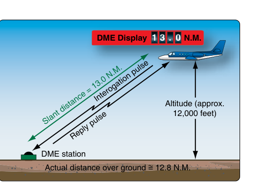
Distance Measuring Equipment (DME) is one of the most useful tools in an IFR pilot's navigation toolkit, providing continuous readouts of distance to a ground-based transponder station. However, there is a subtle but important geometric reality every instrument pilot must understand: DME does not measure the horizontal distance along the ground between your aircraft and the station. Instead, it measures slant range — the straight-line distance through the air from your aircraft to the DME ground antenna. When you are at altitude, that slant-range line travels diagonally, not horizontally, which means the displayed distance is always slightly greater than the true ground distance. This difference is called slant range error.
For most en route IFR flying, slant range error is negligibly small and pilots routinely use DME readouts without correction. But as you get closer to a station and as your altitude increases, this geometric distortion becomes meaningful — and in some instrument procedures, understanding it is critical to flying the approach correctly and safely.
How DME Works
A DME system operates on the interrogation-response principle. Your aircraft's airborne DME interrogator sends paired pulse signals to the ground-based DME transponder (which is typically co-located with a VOR or ILS facility). The ground transponder receives these pulses and responds after a fixed 50-microsecond delay. The airborne unit measures the total round-trip time, subtracts the known 50-microsecond reply delay, and converts that elapsed time to a distance using the speed of radio waves (approximately the speed of light). The result is displayed in nautical miles.
Because radio waves travel in straight lines, the distance being measured is literally the straight-line path from your antenna to the ground antenna. If your aircraft is at any appreciable altitude, this path forms the hypotenuse of a right triangle whose two legs are: (1) your altitude above the DME station elevation, and (2) the true horizontal ground distance to the station. The DME always reads the hypotenuse — never one of the legs.
The Geometry of Slant Range Error
The relationship between slant range, altitude, and ground distance follows the Pythagorean theorem:
Slant Range² = Ground Distance² + Height Above Station²
Where height above station is your altitude minus the station's elevation, expressed in the same units. For practical use, pilots convert altitude to nautical miles: divide feet by 6,076 (feet per nautical mile). So an aircraft 12,000 feet above a station's elevation is roughly 1.97 NM above it vertically.
Consider a concrete example. Suppose you are flying at 6,000 feet directly above a DME station (ground distance = zero). Your DME will display approximately 1 NM (6,076 feet ÷ 6,076 = 1.0 NM) rather than zero, because the slant range equals your altitude above the station. Now move that aircraft 10 NM horizontally from the station at the same 6,000-foot altitude above the station. The slant range is √(10² + 1²) = √101 ≈ 10.05 NM. At 10 NM out, the error is only about 0.05 NM — essentially negligible.
This illustrates the core rule: slant range error is greatest when you are close to the station and at high altitude, and it diminishes rapidly as ground distance increases. As a general rule of thumb from the FAA Instrument Flying Handbook, slant range error is considered negligible when the aircraft is one or more miles away from the station for each 1,000 feet of altitude above the station elevation. So if you are at 8,000 feet AGL above the station, the error becomes approximately negligible somewhere beyond about 8 NM, though this is an approximation rather than a precise cutoff. Within that range, the DME may read noticeably more than your actual ground distance.
Practical Impact During IFR Operations
In most en route navigation, you are flying many miles from any given DME station and slant range error amounts to a tiny fraction of a nautical mile — well within acceptable navigation tolerances. The place where it matters most is during instrument approach procedures that use DME to define stepdown fixes, final approach fix locations, or missed approach points.
On a VOR/DME or ILS/DME approach, the procedure designer accounts for a nominal aircraft altitude and the geometry of the approach when specifying DME distances for fixes. However, the actual slant range error you experience depends on your specific altitude at each fix. If you arrive at a stepdown fix slightly high, your DME will read slightly farther out than the true ground position — meaning you might not yet be at the fix even though the chart distance appears on your indicator. Conversely, if you are low, you will reach the charted DME distance slightly before reaching the true ground position of the fix.
This is particularly relevant at the final approach fix (FAF) on a non-precision approach. If you are high at the FAF, the DME might show you have not yet reached it when in reality you are very close in ground distance. Descent timing based purely on DME in this situation requires awareness of the slant range geometry.
Another practical scenario involves flying directly overhead a VORTAC or VOR/DME station. As you cross overhead, the DME will never read zero — it will read some positive value equal to your altitude above the station in nautical miles. Expect this and do not be confused by it; the system is performing perfectly. The DME will begin counting down again only after you pass the station and the slant range starts increasing on the other side — but momentarily the distance readout may oscillate or flag as the signal geometry becomes unfavorable directly overhead.
DME in RNAV and Modern Avionics
Many RNAV systems use DME/DME positioning, where the flight management system (FMS) interrogates multiple DME stations simultaneously and uses triangulation to compute a precise area navigation position. When two or more DME stations are used at different bearings, the FMS applies geometric calculations that inherently account for slant range, converting slant distances to ground distances as part of the position solution. This is one reason DME/DME RNAV can be quite accurate — the slant range geometry is handled mathematically rather than left as an uncorrected pilot factor.
For GPS-based RNAV, slant range error is not a factor at all, since GPS positioning derives latitude, longitude, and altitude from satellite signals using a fundamentally different geometric approach. When GPS is the primary navigation source, DME is typically used as a backup or for cross-checking.
Key Numbers and Rules
- Slant range error is negligible as a rule of thumb when you are at least 1 NM away from the station for each 1,000 feet of altitude AGL above the station — beyond this approximate distance, the error is small enough to ignore for practical navigation.
- Directly overhead a station, DME reads your altitude above the station in nautical miles (approximately: altitude in feet ÷ 6,076).
- The Pythagorean relationship: Slant Range² = Ground Distance² + (Altitude Above Station)². Pilots don't compute this in flight, but understanding it explains the behavior.
- DME always reads more than true ground distance — never less — because the hypotenuse is always the longest side of the right triangle.
- DME arc procedures: When flying a DME arc, you are holding a constant slant range (displayed DME distance). Because DME reads the hypotenuse, the actual ground track distance from the station is slightly less than the displayed arc distance, meaning the true ground track lies slightly inside the nominal arc radius — though for typical arc altitudes and distances this effect is small.
- Approach procedure designers account for the nominal aircraft altitude in specifying DME fixes, but pilot deviations from that altitude change the error slightly.
Common Test Traps
- Thinking DME reads horizontal distance. The FAA knowledge test frequently exploits the misunderstanding that DME gives ground distance. It measures slant range — always. Expect questions that describe a scenario close to a station at altitude and ask why the DME reads more than expected.
- When is error greatest? The answer is when you are at high altitude and close to the station — both conditions together maximize the error. High altitude alone far from the station produces little error; being close at low altitude also produces little error.
- Directly overhead the station. Students often assume DME will read zero directly overhead. It will not — it reads altitude above the station in nautical miles. A question may describe a DME reading of 1.5 NM overhead and ask what explains it (approximately 9,100 feet AGL above the station, since 1.5 NM × 6,076 feet ≈ 9,114 feet).
- Confusing slant range error with receiver sensitivity. DME flagging or loss of signal directly overhead a station is a separate phenomenon from slant range error. Both can occur near overhead passage, but they are distinct concepts with different causes.
- DME/DME RNAV and slant range. Some questions address whether DME/DME RNAV systems automatically compensate for slant range. The answer is yes — the FMS computes position using the geometry of multiple stations and resolves slant range in its position calculation, giving a more accurate horizontal position than a pilot would derive by using a single DME reading naively.