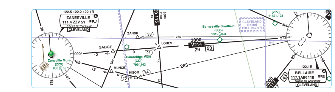
When you fly IFR across the country, you are almost certainly flying along invisible highways in the sky — airways defined by VHF Omni-directional Range (VOR) ground stations and protected by decades of regulatory engineering. Understanding how VOR signals propagate, where they are reliable, and how the airway structure is built on top of those signals is fundamental to instrument rating study. Whether you are filing a flight plan along Victor Airways at 8,000 feet or cruising the Jet Routes at Flight Level 350, every segment of that route traces back to the guaranteed signal coverage of a VOR ground station.
This article explains VOR service volumes in detail, walks through how Victor Airways (also called Low Altitude Federal Airways) and Jet Routes (High Altitude Federal Airways) are constructed around those volumes, and covers the practical and regulatory rules that govern their use — including the testable specifics that instrument rating candidates must know cold.
How VOR Service Volumes Work
A VOR transmits a VHF radio signal (108.0–117.95 MHz) that propagates largely in straight lines. Because the earth curves and terrain can block the signal, coverage is inherently distance- and altitude-dependent. The FAA defines Standard Service Volumes (SSVs) to characterize the guaranteed reception area for each class of VOR. These are the distances and altitudes within which the FAA certifies that a properly functioning airborne receiver will receive a usable signal free from co-channel interference. The Aeronautical Information Manual (AIM) and the Pilot's Handbook of Aeronautical Knowledge (PHAK, FAA-H-8083-25) describe three classic SSV classifications:
- Terminal (T) VOR: Usable up to 25 nautical miles (NM) from the station, from 1,000 feet AGL up to 12,000 feet AGL. Terminal VORs are typically found at or near airports and serve approach and departure navigation, not enroute airway navigation.
- Low Altitude (L) VOR: Usable up to 40 NM from the station, from 1,000 feet AGL up to 18,000 feet AGL. Low Altitude VORs support Victor Airway navigation in the Low Altitude enroute structure (surface to but not including FL 180).
- High Altitude (H) VOR: Usable up to 40 NM from 1,000 to 14,500 feet AGL; up to 100 NM from 14,500 to 18,000 feet AGL; and up to 130 NM from 18,000 feet AGL up to 60,000 feet AGL. High Altitude VORs support Jet Route navigation at and above FL 180, where the greater altitude allows the curvature of the earth and terrain to matter far less.
It is important to understand that these SSVs represent guaranteed minimum coverage — a VOR signal may actually reach farther, but you cannot rely on it for navigation outside the SSV because interference from other stations on the same frequency is no longer controlled beyond those limits. The FAA coordinates VOR frequency assignments based on the SSV of each station to prevent co-channel interference within the defined service volume.
Victor Airways: The Low Altitude Airway Structure
Victor Airways (officially called VOR Federal Airways or Low Altitude Federal Airways) are the enroute corridors used by IFR aircraft operating below 18,000 feet MSL. They are defined in 14 CFR Part 71 and depicted on Enroute Low Altitude charts. Each airway is named with the prefix V followed by a number (for example, V23 or V105). The centerline of each segment connects one VOR radial to another, creating a continuous path between stations.
The width of a Victor Airway is defined as 4 NM on each side of the centerline, giving a total width of 8 NM. However, when the navigable airspace boundary or the edge of the SSV is closer than 4 NM, the airway width narrows accordingly. Obstacle clearance within the airway is guaranteed only when you remain on the centerline within the protected width and at or above the published Minimum Enroute Altitude (MEA) or other applicable altitude (such as the Minimum Obstruction Clearance Altitude, MOCA).
The MEA is the lowest altitude that ensures both obstacle clearance (at least 1,000 feet in non-mountainous areas, 2,000 feet in designated mountainous areas) AND adequate VOR signal reception along the entire airway segment. The MOCA provides the same obstacle clearance but guarantees VOR signal reception only within 22 NM of the station. If ATC assigns you an altitude below the MEA but at or above the MOCA, your VOR navigation may become unreliable beyond 22 NM from either bounding station — a critical distinction for practical navigation.
Victor Airways begin and end at VOR stations, VOR/DME, VORTAC, or other designated navigation fixes. A flight plan filed along Victor Airways simply lists the airways and any required intersection waypoints, making flight planning efficient and standardized.
Jet Routes: The High Altitude Airway Structure
Above 18,000 feet MSL (Class A airspace begins at FL 180), the enroute structure changes to Jet Routes, which are depicted on Enroute High Altitude charts. Jet Routes are named with the prefix J (for example, J42 or J80) and are also defined in 14 CFR Part 71. They span from FL 180 up to and including FL 450.
Like Victor Airways, Jet Routes are based on VOR radials — specifically on High Altitude (H) class VORs whose SSV reaches up to 130 NM at altitude. The wider SSV at high altitudes means that Jet Route segments can be much longer than Victor Airway segments, reducing the number of stations needed to build a transcontinental route. The protected width of a Jet Route is the same 4 NM on each side of centerline as Victor Airways.
In Class A airspace, all flight must be conducted under IFR. ATC provides separation services, and all aircraft must be equipped with appropriate avionics. When operating on Jet Routes, pilots must comply with semi-circular altitude rules that apply to Magnetic Course: odd thousands for courses 0–179° magnetic, even thousands for courses 180–359° magnetic — expressed as flight levels in Class A airspace.
Why Service Volumes and Airways Matter in the Real World
Service volumes and airways are not just textbook abstractions. When you fly IFR, you are implicitly trusting that the VOR you are tracking is within its published SSV and that the airway you are on provides obstacle clearance at your assigned altitude. If you attempt to navigate using a VOR outside its service volume, you may receive a signal — but it could be corrupted by interference from a distant station on the same frequency, leading you off course without any cockpit warning.
Additionally, when planning IFR flights, selecting airways with appropriate MEAs for your aircraft's performance and oxygen equipment requirements is a real preflight task. A route with a segment MEA of 14,000 feet in mountainous terrain requires oxygen for flight crews under 14 CFR 91.211, and some piston aircraft simply cannot sustain that altitude. Knowing how to read High Altitude charts and identify alternate airways or direct routing through RNAV routes is a practical skill that begins with understanding why the airway structure is shaped as it is.
Key Numbers and Rules
- Terminal VOR SSV: 25 NM, 1,000–12,000 feet AGL.
- Low Altitude VOR SSV: 40 NM, 1,000–18,000 feet AGL.
- High Altitude VOR SSV: 40 NM up to 14,500 ft; 100 NM from 14,500–18,000 ft; 130 NM from 18,000–60,000 ft AGL.
- Victor Airway width: 4 NM each side of centerline (8 NM total).
- Jet Route width: 4 NM each side of centerline (8 NM total).
- Victor Airways altitude range: 1,200 feet AGL (in most areas) up to but not including 18,000 feet MSL.
- Jet Routes altitude range: FL 180 up to and including FL 450.
- MEA vs. MOCA: MEA guarantees obstacle clearance AND VOR reception along the full segment. MOCA guarantees obstacle clearance but VOR reception only within 22 NM of the station.
- Mountainous terrain obstacle clearance: 2,000 feet above highest obstacle within the airway; 1,000 feet in non-mountainous areas.
- Class A airspace: Starts at FL 180, requires IFR clearance and appropriate equipment including Mode C transponder.
Common Test Traps
- Confusing MEA and MOCA reception limits: Many candidates believe both guarantee full-segment VOR reception. Only the MEA does. The MOCA guarantees reception only within 22 NM of the VOR — a classic exam question asks which altitude provides signal coverage along the entire segment.
- Mixing up SSV classes: Terminal VORs are limited to 25 NM, which is not sufficient for enroute airway navigation. Do not assume any VOR is an L or H class without checking its chart depiction or the A/FD (Chart Supplement).
- High Altitude VOR distance at different altitudes: Candidates often memorize 130 NM as the universal H-VOR range, but that range only applies at and above 18,000 feet AGL. Below that, the range steps down to 100 NM and 40 NM depending on altitude band.
- Jet Route vs. Victor Airway altitudes: Victor Airways are below FL 180; Jet Routes begin at FL 180. FL 180 itself belongs to Jet Routes and Class A airspace, not the low-altitude structure. This is a commonly exploited boundary question.
- Airway width and obstacle protection: The 8 NM total width (4 NM each side) is the protected width, but obstacle clearance applies only when you are on or above the MEA. Descending below the MEA — even while on centerline — removes the obstacle clearance guarantee. ATC can authorize MOCA operations, but you must understand the reception limitation that comes with it.